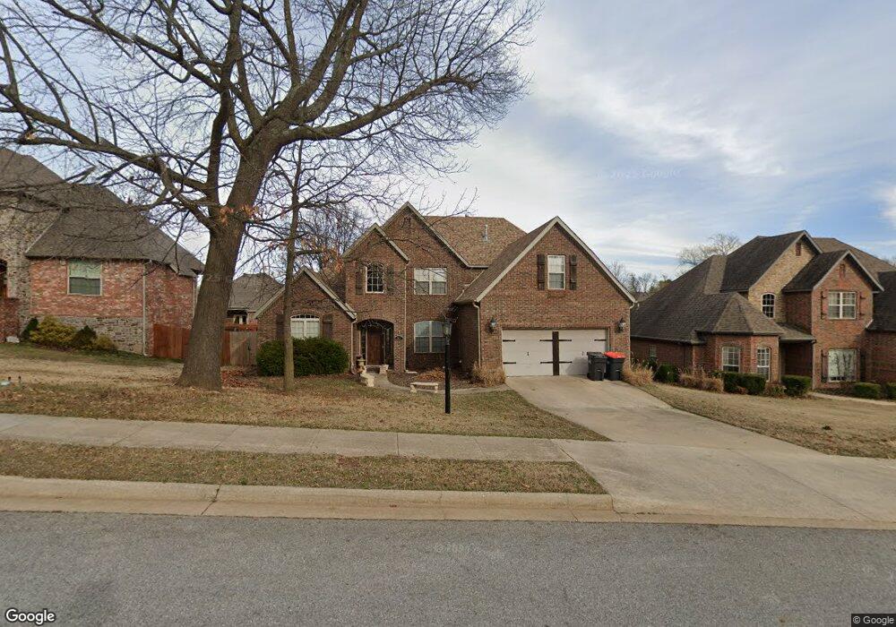
3624 Pasofino Loop Springdale, AR 72764
Estimated Value: $540,000 - $880,000
4
Beds
3
Baths
3,212
Sq Ft
$206/Sq Ft
Est. Value
About This Home
This home is located at 3624 Pasofino Loop, Springdale, AR 72764 and is currently estimated at $661,796, approximately $206 per square foot. 3624 Pasofino Loop is a home located in Benton County with nearby schools including Hunt Elementary School, Central Junior High School, and Hellstern Middle School.
Ownership History
Date
Name
Owned For
Owner Type
Purchase Details
Closed on
Jul 11, 2005
Sold by
Frontier Development Group Inc
Bought by
Clark Lance D and Clark Andrea R
Current Estimated Value
Home Financials for this Owner
Home Financials are based on the most recent Mortgage that was taken out on this home.
Original Mortgage
$32,450
Outstanding Balance
$9,741
Interest Rate
5.58%
Mortgage Type
Credit Line Revolving
Estimated Equity
$652,055
Purchase Details
Closed on
Oct 15, 2004
Bought by
Frontier Dev
Create a Home Valuation Report for This Property
The Home Valuation Report is an in-depth analysis detailing your home's value as well as a comparison with similar homes in the area
Purchase History
| Date | Buyer | Sale Price | Title Company |
|---|---|---|---|
| Clark Lance D | $314,000 | None Available | |
| Frontier Dev | $295,000 | -- |
Source: Public Records
Mortgage History
| Date | Status | Borrower | Loan Amount |
|---|---|---|---|
| Open | Clark Lance D | $32,450 | |
| Open | Clark Lance D | $250,000 |
Source: Public Records
Tax History
| Year | Tax Paid | Tax Assessment Tax Assessment Total Assessment is a certain percentage of the fair market value that is determined by local assessors to be the total taxable value of land and additions on the property. | Land | Improvement |
|---|---|---|---|---|
| 2025 | $3,458 | $96,173 | $24,000 | $72,173 |
| 2024 | $3,376 | $96,173 | $24,000 | $72,173 |
| 2023 | $3,215 | $61,820 | $15,200 | $46,620 |
| 2022 | $2,706 | $61,820 | $15,200 | $46,620 |
| 2021 | $2,555 | $61,820 | $15,200 | $46,620 |
| 2020 | $2,421 | $52,460 | $9,600 | $42,860 |
| 2019 | $2,421 | $52,460 | $9,600 | $42,860 |
| 2018 | $2,446 | $52,460 | $9,600 | $42,860 |
| 2017 | $2,298 | $52,460 | $9,600 | $42,860 |
| 2016 | $2,298 | $52,460 | $9,600 | $42,860 |
| 2015 | $2,522 | $47,320 | $6,800 | $40,520 |
| 2014 | $2,172 | $47,320 | $6,800 | $40,520 |
Source: Public Records
Map
Nearby Homes
- 3450 Pasofino Loop
- 1301 W Morris Ave
- 1483 Leesburg Ave
- 7.25 AC Thompson
- 3751 Alliance Dr
- 0 Graham Rd
- 4661 Carriage Ln
- 3435 Alliance Dr
- 4654 Carriage Ln
- 2122 Wagon Wheel Rd
- 3058 Chelsey Ln
- 2930 Twin County St
- 566 Parkside Cove
- 2690 Ponchartrain St Unit A-B
- 1719 Wensworth Ave
- 5292 N Graham Rd
- 2345 Tall Tree Ln
- 3590 Jefferson St
- 63 Ladawn Ave
- 66 Ladawn Ave
- 3650 Pasofino Loop
- 3606 Pasofino Loop
- 3874 Pasofino Loop
- 3672 Pasofino Loop
- 3850 Pasofino Loop
- 3898 Pasofino Loop
- 3584 Pasofino Loop
- 3826 Pasofino Loop
- 3625 Pasofino Loop
- 3615 Pasofino Loop
- 3914 Pasofino Loop
- 3696 Pasofino Loop
- 3651 Pasofino Loop
- 3607 Pasofino Loop
- 3804 Pasofino Loop
- 3562 Pasofino Loop
- 3585 Pasofino Loop
- 3940 Pasofino Loop
- 3697 Pasofino Loop
- 3561 Pasofino Loop
Your Personal Tour Guide
Ask me questions while you tour the home.