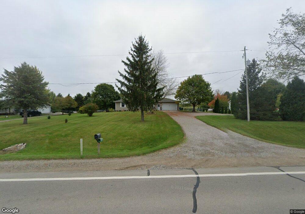
3627 W Lawrence Hwy Charlotte, MI 48813
Estimated Value: $243,000 - $308,000
3
Beds
2
Baths
1,092
Sq Ft
$248/Sq Ft
Est. Value
About This Home
This home is located at 3627 W Lawrence Hwy, Charlotte, MI 48813 and is currently estimated at $271,218, approximately $248 per square foot. 3627 W Lawrence Hwy is a home located in Eaton County with nearby schools including Washington Elementary School, Charlotte Middle School, and Charlotte Upper Elementary School.
Ownership History
Date
Name
Owned For
Owner Type
Purchase Details
Closed on
Jul 27, 2018
Sold by
Adams Kurene J and Jackson Kurene J
Bought by
Rogers Craig and Rogers Miriam
Current Estimated Value
Home Financials for this Owner
Home Financials are based on the most recent Mortgage that was taken out on this home.
Original Mortgage
$160,101
Outstanding Balance
$139,041
Interest Rate
4.5%
Mortgage Type
New Conventional
Estimated Equity
$132,177
Create a Home Valuation Report for This Property
The Home Valuation Report is an in-depth analysis detailing your home's value as well as a comparison with similar homes in the area
Home Values in the Area
Average Home Value in this Area
Purchase History
| Date | Buyer | Sale Price | Title Company |
|---|---|---|---|
| Rogers Craig | $158,500 | Ata Natl Title Group Llc |
Source: Public Records
Mortgage History
| Date | Status | Borrower | Loan Amount |
|---|---|---|---|
| Open | Rogers Craig | $160,101 |
Source: Public Records
Tax History Compared to Growth
Tax History
| Year | Tax Paid | Tax Assessment Tax Assessment Total Assessment is a certain percentage of the fair market value that is determined by local assessors to be the total taxable value of land and additions on the property. | Land | Improvement |
|---|---|---|---|---|
| 2025 | $2,669 | $115,610 | $0 | $0 |
| 2024 | $978 | $110,350 | $0 | $0 |
| 2023 | $931 | $90,020 | $0 | $0 |
| 2022 | $2,351 | $87,190 | $0 | $0 |
| 2021 | $2,262 | $83,120 | $0 | $0 |
| 2020 | $2,201 | $79,200 | $0 | $0 |
| 2019 | $2,170 | $73,400 | $0 | $0 |
| 2018 | $1,814 | $66,243 | $0 | $0 |
| 2017 | $1,747 | $67,259 | $0 | $0 |
| 2016 | -- | $64,567 | $0 | $0 |
| 2015 | -- | $62,675 | $0 | $0 |
| 2014 | -- | $58,436 | $0 | $0 |
| 2013 | -- | $58,669 | $0 | $0 |
Source: Public Records
Map
Nearby Homes
- 220 N Chester Rd
- Vl Montels Parcel D Way
- 0 Montels Parcel H Way
- 4755 Carlisle Hwy
- 854 S Ainger Rd
- 1272 W Lawrence Hwy
- 2402 N Stine Rd
- 525 N Wheaton Rd
- 827 Walnut St
- 0 Parcel A Pinebluff Dr Unit 257983
- 0 Pinebluff Dr Unit 265338
- 0 Pinebluff Dr Parcel P Unit 258042
- Vl W Kinsel Hwy
- 0 Pinebluff Dr Parcel G Unit 258027
- 717 Katies Way
- 757 W Shepherd St
- 738 W Shepherd St
- 717 High St
- 922 High St
- 113 S Clinton St
- 3627 Lawrence Hwy
- 3635 Lawrence Hwy
- 3575 W Lawrence Hwy
- 3539 Lawrence Hwy
- 3645 Lawrence Hwy
- 3639 Lawrence Hwy
- 3723 Lawrence Hwy
- 3809 W Lawrence Hwy
- 3809 Lawrence Hwy
- 3810 Lawrence Hwy
- 3814 Lawrence Hwy
- 3814 Lawrence Hwy
- 3893 Lawrence Hwy
- 3931 W Lawrence Hwy
- 3957 Lawrence Hwy
- 3333 Lawrence Hwy
- 103 S Chester Rd
- 78 N Chester Rd
- 110 N Chester Rd
- 130 N Chester Rd