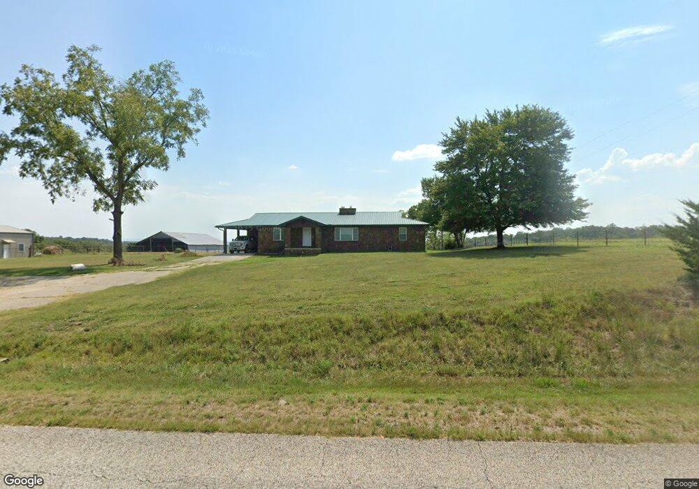
3628 Osbourne Rd Saint Joe, AR 72675
Estimated Value: $351,000 - $461,085
--
Bed
2
Baths
2,399
Sq Ft
$176/Sq Ft
Est. Value
About This Home
This home is located at 3628 Osbourne Rd, Saint Joe, AR 72675 and is currently estimated at $423,362, approximately $176 per square foot. 3628 Osbourne Rd is a home located in Searcy County with nearby schools including St. Joe K-12 School, St. Joe Elementary School, and St. Joe High School.
Ownership History
Date
Name
Owned For
Owner Type
Purchase Details
Closed on
Oct 16, 1995
Bought by
Trogdon David and Trogdon Linda
Current Estimated Value
Purchase Details
Closed on
Nov 1, 1993
Bought by
Trogdon David and Trogdon Linda
Purchase Details
Closed on
Apr 11, 1993
Bought by
Adams
Purchase Details
Closed on
Apr 1, 1993
Bought by
Adams and Adams Adams
Purchase Details
Closed on
Feb 1, 1992
Bought by
Collie
Purchase Details
Closed on
Nov 1, 1979
Bought by
Collie
Purchase Details
Closed on
Mar 22, 1979
Bought by
Trogdon David W
Purchase Details
Closed on
Sep 3, 1971
Bought by
Trogdon David W
Create a Home Valuation Report for This Property
The Home Valuation Report is an in-depth analysis detailing your home's value as well as a comparison with similar homes in the area
Home Values in the Area
Average Home Value in this Area
Purchase History
| Date | Buyer | Sale Price | Title Company |
|---|---|---|---|
| Trogdon David | $67,500 | -- | |
| Trogdon David | -- | -- | |
| Adams | -- | -- | |
| Adams | -- | -- | |
| Collie | -- | -- | |
| Redding | -- | -- | |
| Collie | -- | -- | |
| Trogdon David W | -- | -- | |
| Trogdon David W | -- | -- |
Source: Public Records
Tax History Compared to Growth
Tax History
| Year | Tax Paid | Tax Assessment Tax Assessment Total Assessment is a certain percentage of the fair market value that is determined by local assessors to be the total taxable value of land and additions on the property. | Land | Improvement |
|---|---|---|---|---|
| 2024 | $2,314 | $48,710 | $8,390 | $40,320 |
| 2023 | $819 | $16,980 | $8,390 | $8,590 |
| 2022 | $819 | $16,980 | $8,390 | $8,590 |
| 2021 | $1,641 | $34,200 | $7,340 | $26,860 |
| 2020 | $1,641 | $34,200 | $7,340 | $26,860 |
| 2019 | $1,659 | $34,200 | $7,340 | $26,860 |
| 2018 | $1,659 | $34,200 | $7,340 | $26,860 |
| 2017 | $1,650 | $34,150 | $7,210 | $26,940 |
| 2016 | $1,585 | $34,150 | $7,210 | $26,940 |
| 2014 | $1,587 | $34,210 | $7,270 | $26,940 |
Source: Public Records
Map
Nearby Homes
- 151 White Star Ln
- 305 Spirit Dr
- 237/236 Pride & Joy Ln
- 237 Pride and Joy Ln
- 0000 Tomahawk Slab Rd
- 0 Tomahawk Slab Rd Unit 1319824
- 0 Tomahawk Slab Rd Unit 24581526
- Hwy 333 Lime Dr
- 74 Church St
- 333 Lime Dr
- 002 Tomahawk Slab Rd
- 4292 Tomahawk Slab Rd
- 6518 Tomahawk Church Rd
- 1135 -A Mc 5022
- 1135 Mc 5022
- 12985 U S 65
- 14189 Hwy 65 N
- 429 Farefield Rd
- 205 S Hwy 65
- 18195 Highway 65
- 3824 Osbourne Rd
- 3309 Osbourne Rd
- 456 Booger Road Trail
- 3204 Osbourne Rd
- 374 S Tomahawk Rd
- 301 Little Cedar Ln
- 948 Blue Ribbon Rd
- 4087 Osbourne Rd
- 890 S Tomahawk Rd
- 890 S Tomahawk Rd
- 2901 Osbourne Rd
- S Tomahawk
- 276 S Tomahawk Rd
- 550 Parrot Head Ln
- 550 Parrot Ln
- 170 Beagle Dr
- 233 Apple Ln
- 0 Searcy Road 32 Unit 1192746
- 4480 Osbourne Rd
- 1066 Parrot Ln