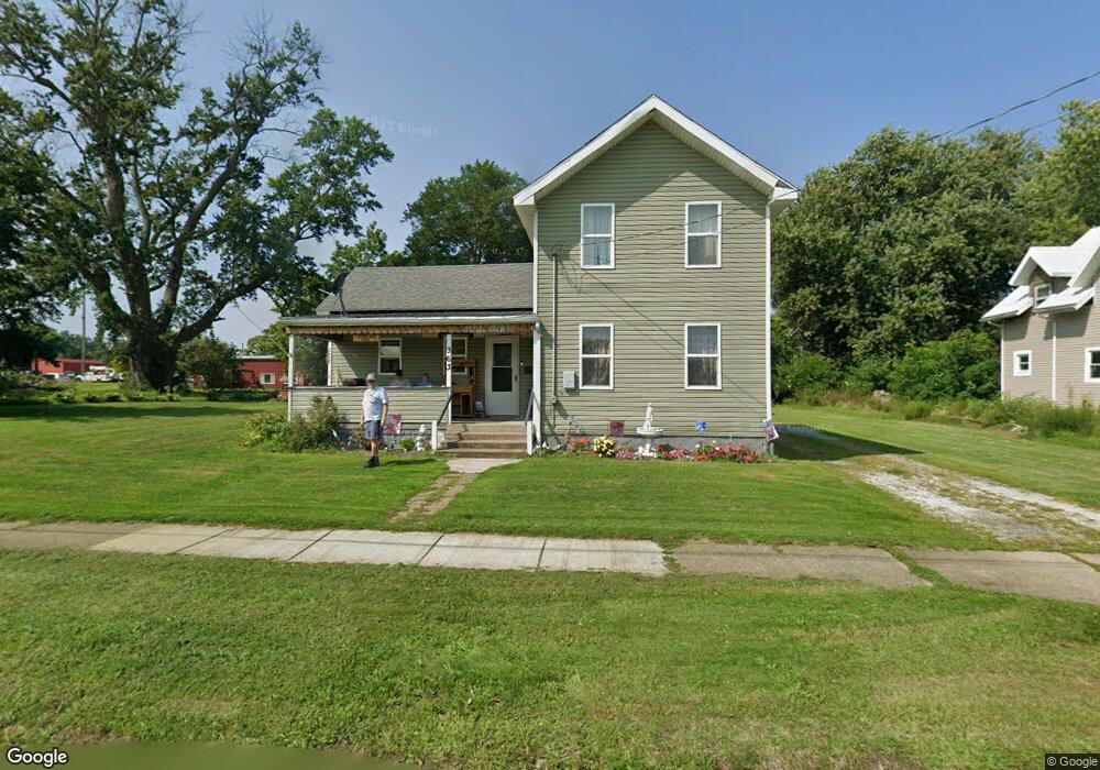
363 Chestnut St Conneaut, OH 44030
Estimated Value: $121,000 - $174,000
4
Beds
2
Baths
1,731
Sq Ft
$82/Sq Ft
Est. Value
About This Home
This home is located at 363 Chestnut St, Conneaut, OH 44030 and is currently estimated at $142,000, approximately $82 per square foot. 363 Chestnut St is a home located in Ashtabula County with nearby schools including Lakeshore Primary Elementary School, Gateway Elementary School, and Conneaut Middle School.
Ownership History
Date
Name
Owned For
Owner Type
Purchase Details
Closed on
Oct 1, 2014
Sold by
Johnston William H and Johnston Betsy J
Bought by
Poff Daniel J and Poff Deborah L
Current Estimated Value
Purchase Details
Closed on
Sep 22, 2011
Sold by
Johnston William H and Johnston Betsy J
Bought by
Johnston William H and Johnston Betsy J
Purchase Details
Closed on
Aug 18, 1998
Sold by
Sabo George
Bought by
Johnston William H and Johnston Betsy J
Purchase Details
Closed on
Oct 11, 1996
Sold by
Thayer Walter E
Bought by
Sabo George
Create a Home Valuation Report for This Property
The Home Valuation Report is an in-depth analysis detailing your home's value as well as a comparison with similar homes in the area
Home Values in the Area
Average Home Value in this Area
Purchase History
| Date | Buyer | Sale Price | Title Company |
|---|---|---|---|
| Poff Daniel J | $15,000 | Buckeye Title | |
| Johnston William H | -- | Attorney | |
| Johnston William H | -- | Attorney | |
| Johnston William H | $18,000 | -- | |
| Sabo George | $20,000 | -- |
Source: Public Records
Tax History Compared to Growth
Tax History
| Year | Tax Paid | Tax Assessment Tax Assessment Total Assessment is a certain percentage of the fair market value that is determined by local assessors to be the total taxable value of land and additions on the property. | Land | Improvement |
|---|---|---|---|---|
| 2024 | $2,955 | $40,400 | $4,100 | $36,300 |
| 2023 | $1,453 | $40,400 | $4,100 | $36,300 |
| 2022 | $1,180 | $31,050 | $3,150 | $27,900 |
| 2021 | $1,200 | $31,050 | $3,150 | $27,900 |
| 2020 | $1,200 | $31,050 | $3,150 | $27,900 |
| 2019 | $208 | $12,400 | $2,700 | $9,700 |
| 2018 | $198 | $12,400 | $2,700 | $9,700 |
| 2017 | $776 | $12,400 | $2,700 | $9,700 |
| 2016 | $881 | $18,030 | $3,920 | $14,110 |
| 2015 | $1,717 | $18,030 | $3,920 | $14,110 |
| 2014 | $788 | $18,030 | $3,920 | $14,110 |
| 2013 | $531 | $12,460 | $1,890 | $10,570 |
Source: Public Records
Map
Nearby Homes
- 371 Chestnut St
- 353 Chestnut St
- 497 W Adams St
- 501 W Adams St
- 391 Chestnut St
- 500 W Adams St
- 508 W Adams St
- 497 W Jackson St
- 399 Chestnut St
- 394 Chestnut St
- 505 W Jackson St
- 400 Chestnut St
- 513 W Jackson St
- 465 Jackson St
- 521 W Jackson St
- 461 Jackson St
- 530 W Adams St
- 413 Chestnut St
- 455 Jackson St
- 500 W Jackson St