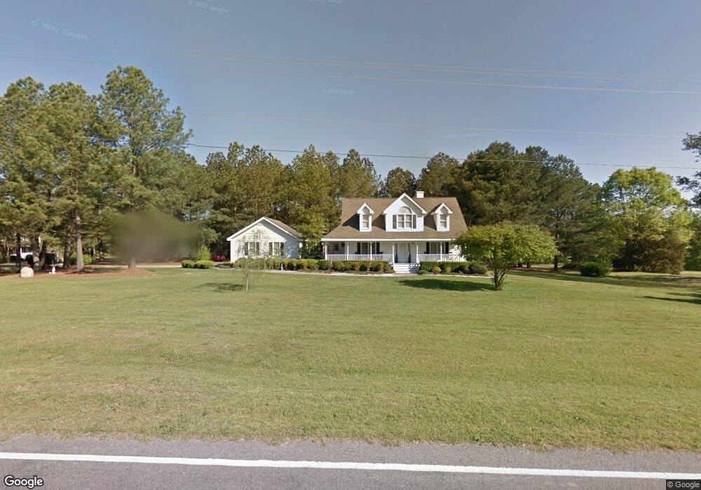
363 Covered Bridge Rd Clayton, NC 27520
Municipal Park NeighborhoodEstimated Value: $378,000 - $412,000
3
Beds
3
Baths
1,830
Sq Ft
$214/Sq Ft
Est. Value
About This Home
This home is located at 363 Covered Bridge Rd, Clayton, NC 27520 and is currently estimated at $392,428, approximately $214 per square foot. 363 Covered Bridge Rd is a home located in Johnston County with nearby schools including Cooper Academy, Riverwood Middle School, and Clayton High.
Ownership History
Date
Name
Owned For
Owner Type
Purchase Details
Closed on
Jun 13, 2005
Sold by
Mitchell Robert S and Mitchell Gena E
Bought by
Ray Michael A and Ray Lisa S
Current Estimated Value
Home Financials for this Owner
Home Financials are based on the most recent Mortgage that was taken out on this home.
Original Mortgage
$164,350
Outstanding Balance
$85,248
Interest Rate
5.66%
Mortgage Type
New Conventional
Estimated Equity
$307,180
Create a Home Valuation Report for This Property
The Home Valuation Report is an in-depth analysis detailing your home's value as well as a comparison with similar homes in the area
Home Values in the Area
Average Home Value in this Area
Purchase History
| Date | Buyer | Sale Price | Title Company |
|---|---|---|---|
| Ray Michael A | $169,000 | None Available |
Source: Public Records
Mortgage History
| Date | Status | Borrower | Loan Amount |
|---|---|---|---|
| Open | Ray Michael A | $164,350 |
Source: Public Records
Tax History Compared to Growth
Tax History
| Year | Tax Paid | Tax Assessment Tax Assessment Total Assessment is a certain percentage of the fair market value that is determined by local assessors to be the total taxable value of land and additions on the property. | Land | Improvement |
|---|---|---|---|---|
| 2025 | $2,167 | $341,300 | $85,000 | $256,300 |
| 2024 | $1,549 | $191,180 | $46,000 | $145,180 |
| 2023 | $1,606 | $191,180 | $46,000 | $145,180 |
| 2022 | $1,620 | $191,180 | $46,000 | $145,180 |
| 2021 | $1,620 | $191,180 | $46,000 | $145,180 |
| 2020 | $1,678 | $191,180 | $46,000 | $145,180 |
| 2019 | $1,678 | $191,180 | $46,000 | $145,180 |
| 2018 | $1,517 | $169,040 | $41,000 | $128,040 |
| 2017 | $1,517 | $169,040 | $41,000 | $128,040 |
| 2016 | $1,483 | $169,040 | $41,000 | $128,040 |
| 2015 | $1,483 | $169,040 | $41,000 | $128,040 |
| 2014 | $1,483 | $169,040 | $41,000 | $128,040 |
Source: Public Records
Map
Nearby Homes
- 20 Windflower Ct Unit Homesite 5
- 34 Windflower Ct Unit Homesite 7
- The Holly Plan at Highgate
- The Concerto Plan at Highgate
- The Hickory Plan at Highgate
- The Maple Plan at Highgate
- 696 Crestdale Dr
- 350 Hopper Cir
- 387 Streamliner Blvd
- 48 Railcar Way Unit Homesite 2
- 27 Windflower Ct
- 35 Windflower Ct
- 21 Windflower Ct
- 36 Railcar Way
- 36 Railcar Way Unit Homesite 1
- 42 Channel Drop Dr
- 528 Ballast Point
- 104 Duba Ct
- 131 Wildflower Cir
- TBD Channel Drop Dr Unit 123
- 306 Queens Ferry Ln
- 26 Windflower Ct
- 20 Windflower Ct
- 313 Covered Bridge Rd
- 310 Queens Ferry Ln
- 307 Queens Ferry Ln
- 43 Windflower Ct
- 101 Hopper Cir
- 408 Covered Bridge Rd
- 408 Covered Bridge Rd
- 311 Queens Ferry Ln
- 69 Hopper Cir Unit 125
- 314 Queens Ferry Ln
- 208 Trotters Run
- 271 Covered Bridge Rd
- 86 Hopper Cir
- 86 Hopper Cir Unit 186
- 315 Queens Ferry Ln
- 66 Hopper Cir Unit 187
- 452 Covered Bridge Rd