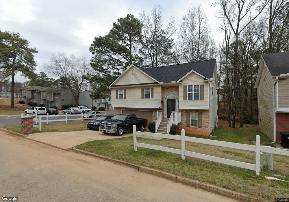
363 Landmark Way Austell, GA 30168
Estimated Value: $276,000 - $315,000
4
Beds
3
Baths
1,146
Sq Ft
$253/Sq Ft
Est. Value
About This Home
This home is located at 363 Landmark Way, Austell, GA 30168 and is currently estimated at $289,663, approximately $252 per square foot. 363 Landmark Way is a home located in Cobb County with nearby schools including Riverside Primary School, Lindley Middle School, and Pebblebrook High School.
Ownership History
Date
Name
Owned For
Owner Type
Purchase Details
Closed on
Dec 30, 2015
Sold by
Miller James E
Bought by
Miller James E and Miller Vivian D
Current Estimated Value
Purchase Details
Closed on
Aug 31, 1999
Sold by
Lowden Land Co
Bought by
Miller James E
Home Financials for this Owner
Home Financials are based on the most recent Mortgage that was taken out on this home.
Original Mortgage
$113,497
Interest Rate
7.5%
Mortgage Type
FHA
Create a Home Valuation Report for This Property
The Home Valuation Report is an in-depth analysis detailing your home's value as well as a comparison with similar homes in the area
Home Values in the Area
Average Home Value in this Area
Purchase History
| Date | Buyer | Sale Price | Title Company |
|---|---|---|---|
| Miller James E | $170,000 | -- | |
| Miller James E | $113,600 | -- |
Source: Public Records
Mortgage History
| Date | Status | Borrower | Loan Amount |
|---|---|---|---|
| Previous Owner | Miller James E | $113,497 |
Source: Public Records
Tax History Compared to Growth
Tax History
| Year | Tax Paid | Tax Assessment Tax Assessment Total Assessment is a certain percentage of the fair market value that is determined by local assessors to be the total taxable value of land and additions on the property. | Land | Improvement |
|---|---|---|---|---|
| 2025 | $3,359 | $111,488 | $22,000 | $89,488 |
| 2024 | $3,843 | $127,456 | $26,000 | $101,456 |
| 2023 | $3,638 | $120,652 | $22,000 | $98,652 |
| 2022 | $2,941 | $96,908 | $12,000 | $84,908 |
| 2021 | $1,985 | $65,420 | $8,000 | $57,420 |
| 2020 | $1,616 | $53,244 | $8,000 | $45,244 |
| 2019 | $1,616 | $53,244 | $8,000 | $45,244 |
| 2018 | $1,180 | $38,880 | $6,800 | $32,080 |
| 2017 | $876 | $30,464 | $4,800 | $25,664 |
| 2016 | $738 | $25,656 | $3,200 | $22,456 |
| 2015 | $756 | $25,656 | $3,200 | $22,456 |
| 2014 | $622 | $20,920 | $0 | $0 |
Source: Public Records
Map
Nearby Homes
- 6914 Fairway Trail
- 6837 Shenandoah Trail
- 306 Bonnes Dr
- 7010 Oakhill Cir
- 7066 Oakhill Cir
- 7074 Oakhill Cir
- 7080 Fringe Flower Dr Unit 18
- 295 Sweetshrub Dr Unit 2
- 6649 Valley Hill Dr SW
- 7224 Kings Cove Unit 10
- 6650 Valley Hill Dr SW
- 6874 Bridgewood Dr
- 201 Wilhelmina Dr
- Foxglove Plan at Leydenview
- Marigold Plan at Leydenview
- 7282 Rockhouse Rd Unit 5
- 6722 Armonia Dr
- 6714 Armonia Dr
- 6696 Armonia Dr
- 6692 Armonia Dr
- 373 Landmark Way
- 383 Landmark Way
- 393 Landmark Way
- 7006 Shenandoah Trail
- 7002 Shenandoah Trail
- 7004 Shenandoah Trail
- 420 Shenandoah Trail
- 403 Landmark Way
- 7008 Shenandoah Trail
- 0 Shenandoah Trail Unit 7420399
- 0 Shenandoah Trail Unit 7007781
- 0 Shenandoah Trail Unit 8705586
- 0 Shenandoah Trail Unit 7565167
- 0 Shenandoah Trail Unit 7313127
- 0 Shenandoah Trail Unit 8862862
- 0 Shenandoah Trail Unit 8297770
- 0 Shenandoah Trail Unit 8677855
- 0 Shenandoah Trail Unit 8147221
- 0 Shenandoah Trail Unit 7292118
- 413 Landmark Way