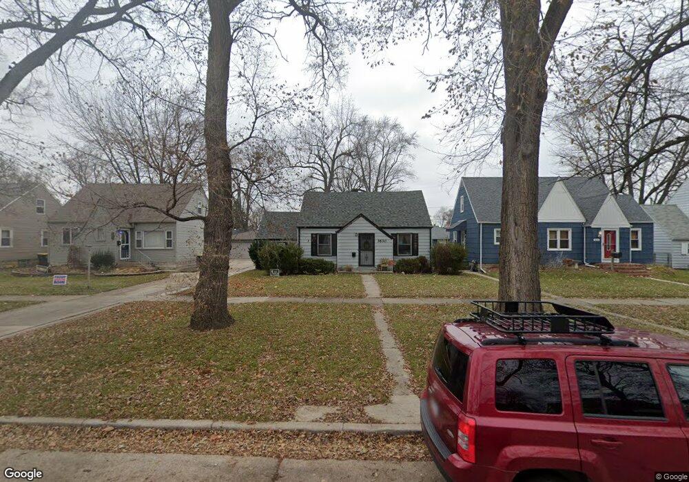
3630 178th St Lansing, IL 60438
Estimated Value: $189,231 - $266,000
3
Beds
2
Baths
1,227
Sq Ft
$181/Sq Ft
Est. Value
About This Home
This home is located at 3630 178th St, Lansing, IL 60438 and is currently estimated at $221,808, approximately $180 per square foot. 3630 178th St is a home located in Cook County with nearby schools including Coolidge Elementary School, Memorial Jr High School, and Thornton Fractnl So High School.
Ownership History
Date
Name
Owned For
Owner Type
Purchase Details
Closed on
Feb 8, 2013
Sold by
David Donna M
Bought by
Marquette Bank and Trust Number 20083
Current Estimated Value
Home Financials for this Owner
Home Financials are based on the most recent Mortgage that was taken out on this home.
Original Mortgage
$176,865
Interest Rate
3.32%
Mortgage Type
Unknown
Purchase Details
Closed on
May 3, 2012
Sold by
Federal Home Loan Mortgage Corporation
Bought by
Davia Donna M
Purchase Details
Closed on
Jan 23, 2012
Sold by
Linz Lisa
Bought by
Federal Home Loan Mortgage Corporation
Create a Home Valuation Report for This Property
The Home Valuation Report is an in-depth analysis detailing your home's value as well as a comparison with similar homes in the area
Home Values in the Area
Average Home Value in this Area
Purchase History
| Date | Buyer | Sale Price | Title Company |
|---|---|---|---|
| Marquette Bank | -- | None Available | |
| Davia Donna M | $40,000 | Attorneys Title Guaranty Fun | |
| Federal Home Loan Mortgage Corporation | -- | None Available |
Source: Public Records
Mortgage History
| Date | Status | Borrower | Loan Amount |
|---|---|---|---|
| Closed | Marquette Bank | $176,865 |
Source: Public Records
Tax History
| Year | Tax Paid | Tax Assessment Tax Assessment Total Assessment is a certain percentage of the fair market value that is determined by local assessors to be the total taxable value of land and additions on the property. | Land | Improvement |
|---|---|---|---|---|
| 2025 | $2,186 | $4,519 | $1,137 | $3,382 |
| 2024 | $2,186 | $4,519 | $1,137 | $3,382 |
| 2023 | $1,778 | $4,519 | $1,137 | $3,382 |
| 2022 | $1,778 | $4,446 | $1,003 | $3,443 |
| 2021 | $1,758 | $4,446 | $1,003 | $3,443 |
| 2020 | $1,698 | $4,446 | $1,003 | $3,443 |
| 2019 | $1,716 | $4,728 | $936 | $3,792 |
| 2018 | $1,682 | $4,728 | $936 | $3,792 |
| 2017 | $1,715 | $4,728 | $936 | $3,792 |
| 2016 | $1,409 | $3,825 | $869 | $2,956 |
| 2015 | $1,277 | $3,825 | $869 | $2,956 |
| 2014 | $1,273 | $3,825 | $869 | $2,956 |
| 2013 | $1,364 | $4,343 | $869 | $3,474 |
Source: Public Records
Map
Nearby Homes
- 3645 177th Place
- 3520 Jackson St
- 17702 Bernadine St
- 3617 Monroe St
- 17945 Maple St
- 17913 William St
- 108 Beverly Place
- 3659 Madison St
- 7937 Forest Ave
- 3522 Washington St
- 17831 Community St
- 222 Beacon Place
- 8039 Forest Ave
- 17821 Roy St
- 17614 Community St
- 17519 Community St
- 3238 178th St
- 17831 Walter St
- 17926 Roy St
- 3527 Lake St
- 3630 178th St
- 3626 178th St
- 3626 178th St
- 3638 178th St
- 3638 178th St
- 3642 178th St
- 3642 178th St
- 3629 177th Place
- 3633 177th Place
- 3625 177th Place
- 3637 177th Place
- 3618 178th St
- 3621 177th Place
- 3641 177th Place
- 3617 177th Place
- 3646 178th St
- 3646 178th St
- 3629 178th St
- 3637 178th St
- 3613 177th Place
Your Personal Tour Guide
Ask me questions while you tour the home.