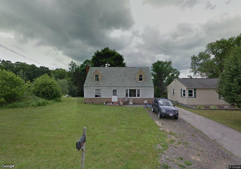
3638 Bon Air Dr Hubbard, OH 44425
Estimated Value: $122,232 - $158,000
3
Beds
1
Bath
912
Sq Ft
$149/Sq Ft
Est. Value
About This Home
This home is located at 3638 Bon Air Dr, Hubbard, OH 44425 and is currently estimated at $135,558, approximately $148 per square foot. 3638 Bon Air Dr is a home located in Trumbull County with nearby schools including Hubbard Elementary School, Hubbard Middle School, and Hubbard High School.
Ownership History
Date
Name
Owned For
Owner Type
Purchase Details
Closed on
Oct 29, 2010
Sold by
Rose Acceptance Inc
Bought by
Thompson Don and Daniels Tamoica
Current Estimated Value
Purchase Details
Closed on
Oct 1, 2010
Sold by
First National Bank Of America
Bought by
Rose Acceptance Inc
Purchase Details
Closed on
Aug 30, 2010
Sold by
Lantz Charles M
Bought by
First National Bank Of America
Purchase Details
Closed on
Jan 1, 1990
Bought by
Charles Francis
Create a Home Valuation Report for This Property
The Home Valuation Report is an in-depth analysis detailing your home's value as well as a comparison with similar homes in the area
Home Values in the Area
Average Home Value in this Area
Purchase History
| Date | Buyer | Sale Price | Title Company |
|---|---|---|---|
| Thompson Don | $10,000 | Commonwealth Suburban Title | |
| Rose Acceptance Inc | -- | Commonwealth Suburban Title | |
| First National Bank Of America | $20,000 | Attorney | |
| Charles Francis | -- | -- |
Source: Public Records
Tax History Compared to Growth
Tax History
| Year | Tax Paid | Tax Assessment Tax Assessment Total Assessment is a certain percentage of the fair market value that is determined by local assessors to be the total taxable value of land and additions on the property. | Land | Improvement |
|---|---|---|---|---|
| 2024 | $331 | $14,880 | $1,440 | $13,440 |
| 2023 | $315 | $14,880 | $1,440 | $13,440 |
| 2022 | $366 | $14,080 | $1,440 | $12,640 |
| 2021 | $368 | $14,080 | $1,440 | $12,640 |
| 2020 | $369 | $14,080 | $1,440 | $12,640 |
| 2019 | $309 | $12,920 | $1,440 | $11,480 |
| 2018 | $301 | $12,920 | $1,440 | $11,480 |
| 2017 | $300 | $12,920 | $1,440 | $11,480 |
| 2016 | $363 | $14,150 | $1,230 | $12,920 |
| 2015 | $364 | $14,150 | $1,230 | $12,920 |
| 2014 | $357 | $14,150 | $1,230 | $12,920 |
| 2013 | $397 | $14,810 | $1,230 | $13,580 |
Source: Public Records
Map
Nearby Homes
- 5843 Fairlawn Ave
- 3943 Logangate Rd
- 6068 Evans Dr
- 0 Homestead Rd
- 2160 Lansdowne Blvd
- 3502 Somerset Dr Unit B
- 2010 Powder Mill Run
- 0 Powder Mill Run Unit 5127327
- 0 Powder Mill Run Unit 5127333
- 3234 Bell Wick Rd
- 2012 Crestwood Blvd
- 2021 Crestwood Blvd
- 3317 Beechwood Dr
- 3275 Beechwood Dr
- 366 Westview Ave
- 257 Westview Ave
- V/L Jacobs Rd
- 3712 Logan Way
- 1363 Country Club Dr
- 9 Redfern Dr
- 3630 Bon Air Dr
- 3660 Bon Air Dr
- 3626 Buena Vista Dr
- 3647 Bon Air Dr
- 3621 Buena Vista Dr
- 3657 Bon Air Dr
- 3628 Buena Vista Dr
- 5778 Youngstown Hubbard Rd
- 3625 Buena Vista Dr
- 3630 Buena Vista Dr
- 3667 Bon Air Dr
- 5786 Youngstown Hubbard Rd
- 3673 Bon Air Dr
- 3627 Buena Vista Dr
- 5767 Youngstown Hubbard Rd
- 3652 Buena Vista Dr
- 3679 Bon Air Dr
- 2 Fairlawn Ave
- 3696 Bon Air Dr
- 3672 Buena Vista Dr