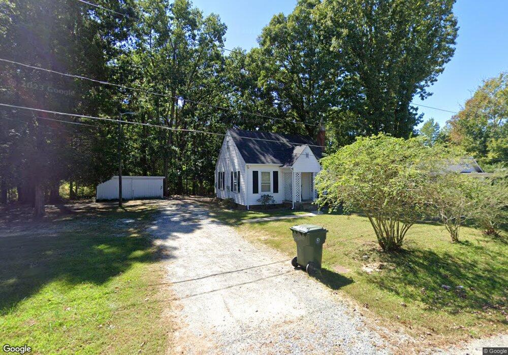
364 Fairgrove Rd Thomasville, NC 27360
Estimated Value: $111,491 - $219,000
2
Beds
1
Bath
792
Sq Ft
$206/Sq Ft
Est. Value
About This Home
This home is located at 364 Fairgrove Rd, Thomasville, NC 27360 and is currently estimated at $163,373, approximately $206 per square foot. 364 Fairgrove Rd is a home located in Davidson County with nearby schools including Fair Grove Elementary School, E. Lawson Brown Middle School, and East Davidson High School.
Ownership History
Date
Name
Owned For
Owner Type
Purchase Details
Closed on
Sep 17, 2008
Sold by
Marion Tracy Soles and Marion Mark B
Bought by
Barnes Dalton R and Barnes Nancy J
Current Estimated Value
Home Financials for this Owner
Home Financials are based on the most recent Mortgage that was taken out on this home.
Original Mortgage
$70,713
Outstanding Balance
$46,966
Interest Rate
6.49%
Mortgage Type
FHA
Estimated Equity
$116,407
Purchase Details
Closed on
Sep 1, 1993
Create a Home Valuation Report for This Property
The Home Valuation Report is an in-depth analysis detailing your home's value as well as a comparison with similar homes in the area
Home Values in the Area
Average Home Value in this Area
Purchase History
| Date | Buyer | Sale Price | Title Company |
|---|---|---|---|
| Barnes Dalton R | $72,000 | None Available | |
| -- | $48,000 | -- |
Source: Public Records
Mortgage History
| Date | Status | Borrower | Loan Amount |
|---|---|---|---|
| Open | Barnes Dalton R | $70,713 |
Source: Public Records
Tax History Compared to Growth
Tax History
| Year | Tax Paid | Tax Assessment Tax Assessment Total Assessment is a certain percentage of the fair market value that is determined by local assessors to be the total taxable value of land and additions on the property. | Land | Improvement |
|---|---|---|---|---|
| 2025 | $710 | $62,140 | $0 | $0 |
| 2024 | $710 | $62,140 | $0 | $0 |
| 2023 | $710 | $62,140 | $0 | $0 |
| 2022 | $710 | $62,140 | $0 | $0 |
| 2021 | $710 | $62,140 | $0 | $0 |
| 2020 | $686 | $61,110 | $0 | $0 |
| 2019 | $697 | $61,110 | $0 | $0 |
| 2018 | $697 | $61,110 | $0 | $0 |
| 2017 | $697 | $61,110 | $0 | $0 |
| 2016 | $356 | $61,110 | $0 | $0 |
| 2015 | $672 | $61,110 | $0 | $0 |
| 2014 | $780 | $70,900 | $0 | $0 |
Source: Public Records
Map
Nearby Homes
- 223 S Westwood Ave
- 73 Harris Farm Ct
- 296 Fairgrove Rd
- 1 Westwood Ave
- 300 Willowbrook Dr
- 122 S Old Fisher Ferry Rd
- 0 Smith Dr
- 307 Fisher Ferry St
- 123 Brooke Ridge Dr
- 25 Cedar Lodge Rd
- 109 Fletcher's Farm Dr
- 106 Kincemac Dr
- 107 Fletcher's Farm Dr
- 1111 Forest Ln
- 708 Ferndale Dr
- 6 Curtis Ct
- Freeport Plan at Aspen Place
- GALEN Plan at Aspen Place
- HAYDEN Plan at Aspen Place
- TAYLOR Plan at Aspen Place
- 346 Fairgrove Rd
- 328 Fairgrove Rd
- 404 Fairgrove Rd
- 270 Fairgrove Rd
- 578 Fairgrove
- 215 Forest Dr
- 258 Fairgrove Rd
- 218 Forest Dr
- 242 Fairgrove Rd
- 213 Forest Dr
- 436 Fairgrove Rd
- 212 Forest Dr
- 439 Fairgrove Rd
- 211 Forest Dr
- 211 Forest Dr Unit 1
- 450 Fairgrove Rd
- 271 Fairgrove Rd
- 214 Fairgrove Rd
- 210 Forest Dr
- 457 Fairgrove Rd