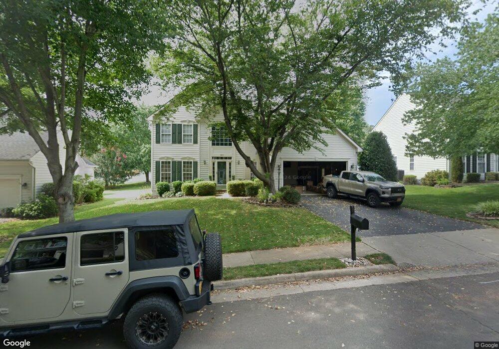
364 Singleton Cir Warrenton, VA 20186
Estimated Value: $650,000 - $745,000
4
Beds
3
Baths
2,634
Sq Ft
$260/Sq Ft
Est. Value
About This Home
This home is located at 364 Singleton Cir, Warrenton, VA 20186 and is currently estimated at $683,917, approximately $259 per square foot. 364 Singleton Cir is a home located in Fauquier County with nearby schools including James G. Brumfield Elementary School, W.C. Taylor Middle School, and Fauquier High School.
Ownership History
Date
Name
Owned For
Owner Type
Purchase Details
Closed on
Oct 24, 2017
Sold by
Goff Ginger and Goff Glen A
Bought by
Goff Glen A
Current Estimated Value
Purchase Details
Closed on
Mar 18, 2002
Sold by
N V R Inc
Bought by
Goff Glen A
Home Financials for this Owner
Home Financials are based on the most recent Mortgage that was taken out on this home.
Original Mortgage
$215,300
Outstanding Balance
$88,987
Interest Rate
6.91%
Mortgage Type
New Conventional
Estimated Equity
$594,930
Create a Home Valuation Report for This Property
The Home Valuation Report is an in-depth analysis detailing your home's value as well as a comparison with similar homes in the area
Home Values in the Area
Average Home Value in this Area
Purchase History
| Date | Buyer | Sale Price | Title Company |
|---|---|---|---|
| Goff Glen A | -- | None Available | |
| Goff Glen A | $269,140 | -- |
Source: Public Records
Mortgage History
| Date | Status | Borrower | Loan Amount |
|---|---|---|---|
| Open | Goff Glen A | $215,300 |
Source: Public Records
Tax History
| Year | Tax Paid | Tax Assessment Tax Assessment Total Assessment is a certain percentage of the fair market value that is determined by local assessors to be the total taxable value of land and additions on the property. | Land | Improvement |
|---|---|---|---|---|
| 2025 | $4,975 | $514,500 | $135,000 | $379,500 |
| 2024 | $4,852 | $514,500 | $135,000 | $379,500 |
| 2023 | $4,646 | $514,500 | $135,000 | $379,500 |
| 2022 | $4,646 | $514,500 | $135,000 | $379,500 |
| 2021 | $3,929 | $395,300 | $125,000 | $270,300 |
| 2020 | $3,929 | $395,300 | $125,000 | $270,300 |
| 2019 | $3,929 | $395,300 | $125,000 | $270,300 |
| 2018 | $3,882 | $395,300 | $125,000 | $270,300 |
| 2016 | $3,855 | $371,000 | $125,000 | $246,000 |
| 2015 | -- | $371,000 | $125,000 | $246,000 |
| 2014 | -- | $371,000 | $125,000 | $246,000 |
Source: Public Records
Map
Nearby Homes
- 0 Walker Dr Unit A-103 VAFQ2015990
- 0 Walker Dr Unit A-104 VAFQ2015992
- 0 Walker Dr Unit A-102 VAFQ2015988
- 0 Walker Dr Unit A-113 VAFQ2015994
- 0 Walker Dr Unit A-101 VAFQ2015948
- 0 Walker Dr Unit A-112 VAFQ2015996
- 186 Sterling Ct
- 226 Breezewood Dr
- 141 Haiti St
- 135 Haiti St
- 2 Millfield Dr
- LOT 1 Blackwell Rd
- 274 Hidden Creek Ln
- 158 N View Cir
- 224 N View Cir
- 173 Autumn Wind Ct
- 114 Erin Dr
- 311 Winterset Ln
- 0 Winchester St
- 50 Culpeper St
- 356 Singleton Cir
- 370 Singleton Cir
- 378 Singleton Cir
- 361 Cannon Way
- 369 Cannon Way
- 348 Singleton Cir
- 353 Cannon Way
- 363 Singleton Cir
- 377 Cannon Way
- 355 Singleton Cir
- 371 Singleton Cir
- 386 Singleton Cir
- 377 Singleton Cir
- 345 Cannon Way
- 345 Singleton Cir
- 385 Cannon Way
- 346 Singleton Cir
- 390 Singleton Cir
- 385 Singleton Cir
- 344 Singleton Cir
Your Personal Tour Guide
Ask me questions while you tour the home.