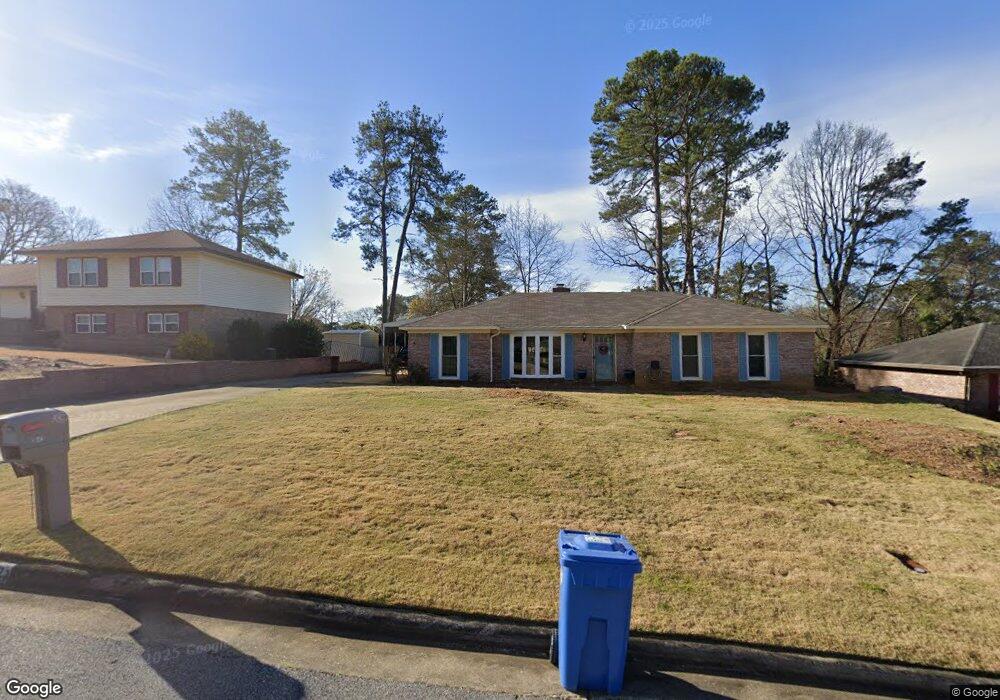
3642 Ginger Dr Columbus, GA 31909
North Columbus NeighborhoodEstimated Value: $230,404 - $278,000
4
Beds
3
Baths
1,652
Sq Ft
$154/Sq Ft
Est. Value
About This Home
This home is located at 3642 Ginger Dr, Columbus, GA 31909 and is currently estimated at $254,601, approximately $154 per square foot. 3642 Ginger Dr is a home located in Muscogee County with nearby schools including Blanchard Elementary School, Veterans Memorial Middle School, and Shaw High School.
Ownership History
Date
Name
Owned For
Owner Type
Purchase Details
Closed on
Nov 30, 2017
Sold by
Olsen Amanda
Bought by
Britt Richard Steven and Britt Amy Gail
Current Estimated Value
Home Financials for this Owner
Home Financials are based on the most recent Mortgage that was taken out on this home.
Original Mortgage
$135,938
Outstanding Balance
$115,695
Interest Rate
4.37%
Mortgage Type
FHA
Estimated Equity
$138,906
Purchase Details
Closed on
May 16, 2013
Sold by
Anderson Cora Gail
Bought by
Olsen Amanda M
Home Financials for this Owner
Home Financials are based on the most recent Mortgage that was taken out on this home.
Original Mortgage
$137,464
Interest Rate
3.25%
Mortgage Type
FHA
Create a Home Valuation Report for This Property
The Home Valuation Report is an in-depth analysis detailing your home's value as well as a comparison with similar homes in the area
Home Values in the Area
Average Home Value in this Area
Purchase History
| Date | Buyer | Sale Price | Title Company |
|---|---|---|---|
| Britt Richard Steven | $138,500 | -- | |
| Olsen Amanda M | $140,000 | -- |
Source: Public Records
Mortgage History
| Date | Status | Borrower | Loan Amount |
|---|---|---|---|
| Open | Britt Richard Steven | $135,938 | |
| Previous Owner | Olsen Amanda M | $137,464 |
Source: Public Records
Tax History
| Year | Tax Paid | Tax Assessment Tax Assessment Total Assessment is a certain percentage of the fair market value that is determined by local assessors to be the total taxable value of land and additions on the property. | Land | Improvement |
|---|---|---|---|---|
| 2025 | $163 | $75,720 | $13,244 | $62,476 |
| 2024 | $1,631 | $75,720 | $13,244 | $62,476 |
| 2023 | $947 | $75,720 | $13,244 | $62,476 |
| 2022 | $1,701 | $60,848 | $13,244 | $47,604 |
| 2021 | $1,694 | $54,884 | $13,244 | $41,640 |
| 2020 | $1,695 | $54,884 | $13,244 | $41,640 |
| 2019 | $1,702 | $54,884 | $13,244 | $41,640 |
| 2018 | $1,702 | $54,884 | $13,244 | $41,640 |
| 2017 | $1,755 | $54,884 | $13,244 | $41,640 |
| 2016 | $1,763 | $56,000 | $6,461 | $49,539 |
| 2015 | $1,765 | $56,000 | $6,461 | $49,539 |
| 2014 | $1,768 | $56,000 | $6,461 | $49,539 |
| 2013 | -- | $53,201 | $6,461 | $46,740 |
Source: Public Records
Map
Nearby Homes
- 19 Nettle Ct
- 3805 Gray Fox Dr
- 3725 Nutmeg Dr
- 2 Nightwind Ct
- 6697 Springlake Dr
- 3646 Weems Rd
- 3845 Arrel Dr
- 6411 Michael Ave
- 6221 Charing Dr
- 2 Biltmore Ct
- 3325 N Quay Dr
- 4348 White Clover Trail
- 4001 Twilight Dr
- 4968 Daybreak Ln
- 4405 Greenridge Dr
- 3783 Cardinal Landing Dr
- 6104 Windsor Dr
- 3775 Cardinal Landing Dr
- 4202 Cheshire Bridge Rd
- 6002 Canterbury Dr
Your Personal Tour Guide
Ask me questions while you tour the home.