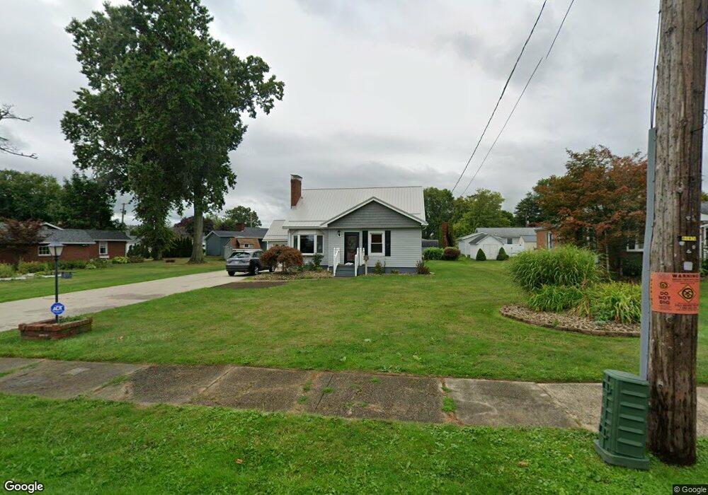
365 Detroit St Conneaut, OH 44030
Estimated Value: $161,489 - $258,000
3
Beds
2
Baths
1,372
Sq Ft
$137/Sq Ft
Est. Value
About This Home
This home is located at 365 Detroit St, Conneaut, OH 44030 and is currently estimated at $188,372, approximately $137 per square foot. 365 Detroit St is a home located in Ashtabula County with nearby schools including Lakeshore Primary Elementary School, Gateway Elementary School, and Conneaut Middle School.
Ownership History
Date
Name
Owned For
Owner Type
Purchase Details
Closed on
Jun 7, 2023
Sold by
Andes Dale A and Andes Pamela S
Bought by
Gustafson Michael T and Blood Alyssa J
Current Estimated Value
Purchase Details
Closed on
Jun 20, 1995
Sold by
Williams Mary
Bought by
Andes Dale A and Andes Pamela S
Home Financials for this Owner
Home Financials are based on the most recent Mortgage that was taken out on this home.
Original Mortgage
$70,200
Interest Rate
8.27%
Mortgage Type
New Conventional
Create a Home Valuation Report for This Property
The Home Valuation Report is an in-depth analysis detailing your home's value as well as a comparison with similar homes in the area
Home Values in the Area
Average Home Value in this Area
Purchase History
| Date | Buyer | Sale Price | Title Company |
|---|---|---|---|
| Gustafson Michael T | -- | None Listed On Document | |
| Andes Dale A | $78,000 | -- |
Source: Public Records
Mortgage History
| Date | Status | Borrower | Loan Amount |
|---|---|---|---|
| Previous Owner | Andes Dale A | $70,200 |
Source: Public Records
Tax History Compared to Growth
Tax History
| Year | Tax Paid | Tax Assessment Tax Assessment Total Assessment is a certain percentage of the fair market value that is determined by local assessors to be the total taxable value of land and additions on the property. | Land | Improvement |
|---|---|---|---|---|
| 2024 | $2,612 | $35,700 | $6,510 | $29,190 |
| 2023 | $1,659 | $35,700 | $6,510 | $29,190 |
| 2022 | $1,407 | $26,640 | $5,010 | $21,630 |
| 2021 | $1,431 | $26,640 | $5,010 | $21,630 |
| 2020 | $1,431 | $26,640 | $5,010 | $21,630 |
| 2019 | $1,392 | $25,450 | $5,010 | $20,440 |
| 2018 | $1,327 | $25,450 | $5,010 | $20,440 |
| 2017 | $1,325 | $25,450 | $5,010 | $20,440 |
| 2016 | $1,177 | $24,650 | $4,870 | $19,780 |
| 2015 | $1,189 | $24,650 | $4,870 | $19,780 |
| 2014 | $1,047 | $24,650 | $4,870 | $19,780 |
| 2013 | $1,202 | $29,120 | $5,530 | $23,590 |
Source: Public Records
Map
Nearby Homes
- 973 Buffalo St
- 794 Buffalo St
- 770 Buffalo St
- 290 Park Ave
- 703 Sandusky St
- 716 Chestnut St
- 688 Grove St
- 1025 Harbor St Unit 35
- 982 Day St
- 0 Harbor St Unit 5122727
- 169 River St
- 644 Mill St
- 630 Mill St
- 554 Sandusky St
- 0 Chestnut St Unit 5120761
- 533 Mill St
- 536 Mill St
- 381 Bliss Ave
- 535 Blair St
- 405 Bliss Ave