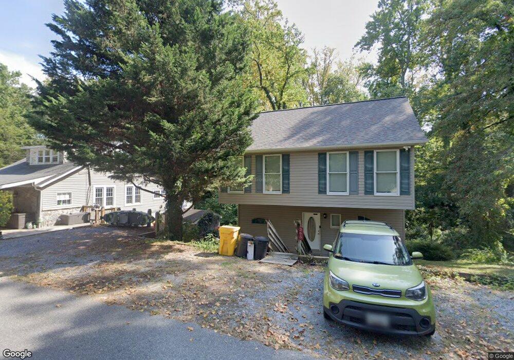
365 Hall Rd Crownsville, MD 21032
Herald Harbor NeighborhoodEstimated Value: $414,546 - $508,000
--
Bed
3
Baths
1,440
Sq Ft
$331/Sq Ft
Est. Value
About This Home
This home is located at 365 Hall Rd, Crownsville, MD 21032 and is currently estimated at $476,137, approximately $330 per square foot. 365 Hall Rd is a home located in Anne Arundel County with nearby schools including South Shore Elementary School, Old Mill High School, and Rockbridge Academy.
Ownership History
Date
Name
Owned For
Owner Type
Purchase Details
Closed on
May 22, 2002
Sold by
Clifford Matthew Vincent
Bought by
Collison Vance
Current Estimated Value
Purchase Details
Closed on
Jan 29, 2002
Sold by
M V Clifford Enterprises Llc
Bought by
Clifford Matthew Vincent and Clifford Belinda Ann
Purchase Details
Closed on
Mar 12, 2001
Sold by
Clifford Matthew V
Bought by
M V Clifford Enterprises Llc
Purchase Details
Closed on
Jan 25, 2001
Sold by
Clifford Belinda
Bought by
Clifford Matthew V and Clifford Belinda
Create a Home Valuation Report for This Property
The Home Valuation Report is an in-depth analysis detailing your home's value as well as a comparison with similar homes in the area
Home Values in the Area
Average Home Value in this Area
Purchase History
| Date | Buyer | Sale Price | Title Company |
|---|---|---|---|
| Collison Vance | $179,000 | -- | |
| Clifford Matthew Vincent | $181,000 | -- | |
| M V Clifford Enterprises Llc | -- | -- | |
| Clifford Matthew V | -- | -- |
Source: Public Records
Mortgage History
| Date | Status | Borrower | Loan Amount |
|---|---|---|---|
| Closed | Clifford Matthew Vincent | -- |
Source: Public Records
Tax History Compared to Growth
Tax History
| Year | Tax Paid | Tax Assessment Tax Assessment Total Assessment is a certain percentage of the fair market value that is determined by local assessors to be the total taxable value of land and additions on the property. | Land | Improvement |
|---|---|---|---|---|
| 2025 | $4,433 | $381,800 | $234,400 | $147,400 |
| 2024 | $4,433 | $359,000 | $0 | $0 |
| 2023 | $4,145 | $336,200 | $0 | $0 |
| 2022 | $3,705 | $313,400 | $204,400 | $109,000 |
| 2021 | $7,336 | $309,833 | $0 | $0 |
| 2020 | $3,591 | $306,267 | $0 | $0 |
| 2019 | $3,557 | $302,700 | $148,400 | $154,300 |
| 2018 | $3,030 | $298,800 | $0 | $0 |
| 2017 | $3,388 | $294,900 | $0 | $0 |
| 2016 | -- | $291,000 | $0 | $0 |
| 2015 | -- | $290,733 | $0 | $0 |
| 2014 | -- | $290,467 | $0 | $0 |
Source: Public Records
Map
Nearby Homes
- 359 Hall Rd
- 852 Birch Trail
- 872 Redwood Trail
- Lots 25 and 26 Redwood Trail
- Lots 27 and 28 Redwood Trail
- Lots 23 and 24 Redwood Trail
- 0 Whitewood Trail
- 0 Redwood Trail Unit MDAA2111808
- 0 Redwood Trail Unit MDAA2111804
- 0 Herald Harbor Rd Unit MDAA2123892
- 355 Kyle Rd
- 938 Diggs Rd
- 975 Diggs Rd
- 902 Hine Trail
- 0 Elm Trail
- 0 Yew Trail Unit MDAA2121932
- 0 Beech Trail
- 478 Mountain Rd
- 330 S Riverside Dr
- 366 Walnut Trail