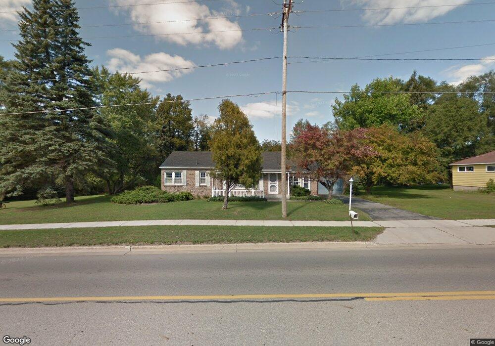
365 W Muskegon St Unit B Cedar Springs, MI 49319
Estimated Value: $278,000 - $328,942
3
Beds
2
Baths
1,344
Sq Ft
$223/Sq Ft
Est. Value
About This Home
This home is located at 365 W Muskegon St Unit B, Cedar Springs, MI 49319 and is currently estimated at $300,236, approximately $223 per square foot. 365 W Muskegon St Unit B is a home located in Kent County with nearby schools including Cedar Trails Elementary School, Red Hawk Intermediate School, and Beach Elementary School.
Ownership History
Date
Name
Owned For
Owner Type
Purchase Details
Closed on
Aug 9, 2019
Sold by
The Bremmer Family Trust
Bought by
Botruff Chris
Current Estimated Value
Purchase Details
Closed on
Dec 1, 2006
Sold by
Bremmer Arwin E
Bought by
Bremmer Arwin E
Purchase Details
Closed on
Oct 31, 2006
Sold by
Bremmer Arwin E and Bremmer Nancy L
Bought by
Bremmer Arwin E
Purchase Details
Closed on
Jan 18, 2005
Sold by
Nolff Tom and Nolff Toni R
Bought by
Afton & Sons Holdings Llc
Create a Home Valuation Report for This Property
The Home Valuation Report is an in-depth analysis detailing your home's value as well as a comparison with similar homes in the area
Home Values in the Area
Average Home Value in this Area
Purchase History
| Date | Buyer | Sale Price | Title Company |
|---|---|---|---|
| Botruff Chris | $160,000 | None Available | |
| Bremmer Arwin E | -- | None Available | |
| Bremmer Arwin E | -- | None Available | |
| Afton & Sons Holdings Llc | $59,500 | -- |
Source: Public Records
Tax History Compared to Growth
Tax History
| Year | Tax Paid | Tax Assessment Tax Assessment Total Assessment is a certain percentage of the fair market value that is determined by local assessors to be the total taxable value of land and additions on the property. | Land | Improvement |
|---|---|---|---|---|
| 2025 | $5,581 | $161,300 | $0 | $0 |
| 2024 | $5,581 | $147,900 | $0 | $0 |
| 2023 | $5,315 | $135,800 | $0 | $0 |
| 2022 | $5,287 | $95,200 | $0 | $0 |
| 2021 | $5,209 | $93,700 | $0 | $0 |
| 2020 | $5,000 | $79,500 | $0 | $0 |
| 2019 | $2,282 | $74,900 | $0 | $0 |
| 2018 | $2,233 | $68,400 | $0 | $0 |
| 2017 | $2,172 | $63,300 | $0 | $0 |
| 2016 | $2,110 | $48,800 | $0 | $0 |
| 2015 | -- | $48,800 | $0 | $0 |
| 2013 | -- | $47,400 | $0 | $0 |
Source: Public Records
Map
Nearby Homes
- 4398 17 Mile Rd NE
- 373 Cedar St NE
- 295 8th St NE
- 340 West St
- 260 Pear St NE
- 139 N 5th St NE
- 69 S Main
- 71 N 2nd St NE
- 115 E Cherry St NE
- 197 E Elm St
- 281 Ronald St NE
- 520 Needlewood Dr
- 490 Pioneer Trail
- 224 Ann St NE
- 249 Maple
- 322 E Ash St NE
- 361 Ronald St NE
- 369 E Muskegon St
- 551 Hawk Wood Ct
- 571 Pioneer Trail
- 365 W Muskegon St
- 370 W Muskegon St
- 349 W Muskegon St
- 380 W Muskegon St
- 0 17 Mile Rd NE Unit M17029646
- 11063 17 Mile Rd NE
- 20202022 17 Mile Rd NE
- 6113 17 Mile Rd NE
- 0 17 Mile Rd NE Unit APP 6 3351543
- 0 17 Mile Rd NE Unit Par G 3315814
- 0 17 Mile Rd NE Unit Par F 3315816
- 0 17 Mile Rd NE Unit Par E 3315817
- 0 17 Mile Rd NE Unit APP 5 3315571
- 0 17 Mile Rd NE Unit 3307457
- 0 17 Mile Rd NE Unit APP 1 3299960
- 0 17 Mile Rd NE Unit Appx 3285318
- 0 17 Mile Rd NE Unit Appx 3285317
- 0 17 Mile Rd NE Unit Appx 3285319
- 0 17 Mile Rd NE Unit 3273619
- 0 17 Mile Rd NE Unit APP 6 3273709