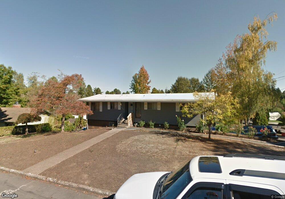
3652 Edward Dr SE Salem, OR 97302
Morningside NeighborhoodEstimated Value: $524,839 - $601,000
1
Bed
2
Baths
2,832
Sq Ft
$200/Sq Ft
Est. Value
About This Home
This home is located at 3652 Edward Dr SE, Salem, OR 97302 and is currently estimated at $565,460, approximately $199 per square foot. 3652 Edward Dr SE is a home located in Marion County with nearby schools including Morningside Elementary School, Leslie Middle School, and South Salem High School.
Ownership History
Date
Name
Owned For
Owner Type
Purchase Details
Closed on
Feb 28, 2014
Sold by
Cannon Thomas L and Cannon Linda R
Bought by
Cannon Thomas L and Cannon Linda R
Current Estimated Value
Create a Home Valuation Report for This Property
The Home Valuation Report is an in-depth analysis detailing your home's value as well as a comparison with similar homes in the area
Home Values in the Area
Average Home Value in this Area
Purchase History
| Date | Buyer | Sale Price | Title Company |
|---|---|---|---|
| Cannon Thomas L | -- | First American Title |
Source: Public Records
Tax History Compared to Growth
Tax History
| Year | Tax Paid | Tax Assessment Tax Assessment Total Assessment is a certain percentage of the fair market value that is determined by local assessors to be the total taxable value of land and additions on the property. | Land | Improvement |
|---|---|---|---|---|
| 2025 | $5,091 | $267,070 | -- | -- |
| 2024 | $5,091 | $259,300 | -- | -- |
| 2023 | $4,941 | $251,750 | $0 | $0 |
| 2022 | $4,659 | $244,420 | $0 | $0 |
| 2021 | $4,526 | $237,310 | $0 | $0 |
| 2020 | $4,394 | $230,400 | $0 | $0 |
| 2019 | $4,239 | $223,690 | $0 | $0 |
| 2018 | $4,314 | $0 | $0 | $0 |
| 2017 | $3,894 | $0 | $0 | $0 |
| 2016 | $3,709 | $0 | $0 | $0 |
| 2015 | $3,737 | $0 | $0 | $0 |
| 2014 | $3,617 | $0 | $0 | $0 |
Source: Public Records
Map
Nearby Homes
- 2010 Audubon Ave SE
- 1655 Corina Dr SE
- 3732 Village Center Dr SE
- 1620 Marshall Dr SE
- 2116 Audubon Ave SE
- 3950 Bartholomew Place SE
- 1892 Cousteau Loop SE
- 4039 Village Center Dr SE
- 1633 Leslie Wind Ln SE
- 4072 Dornoch Ln SE
- 4059 Dornoch Ln SE
- 2094 Legacy Heights Dr SE
- 4030 Cheshire Ln SE
- 1720 Strong Rd SE
- 1299 Marshall Dr SE
- 1714 Strong Rd SE
- 1702 Strong Rd SE
- 1710 Strong Rd SE
- 1792 Strong Rd SE
- 1290 Madrona Ave SE
- 1855 Corina Dr SE
- 3622 Edward Dr SE
- 1860 Aerial Way SE
- 3655 Edward Dr SE
- 1895 Corina Dr SE
- 3696 Edward Dr SE
- 1880 Aerial Way SE
- 1850 Corina Dr SE
- 3615 Edward Dr SE
- 1790 Corina Dr SE
- 1765 Corina Dr SE
- 1890 Corina Dr SE
- 1770 Corina Dr SE
- 3605 Edward Dr SE
- 1765 Aerial Way SE
- 3728 Edward Dr SE
- 1725 Corina Dr SE
- 1855 Ewald Ave SE
- 1865 Aerial Way SE
- 1845 Aerial Way SE