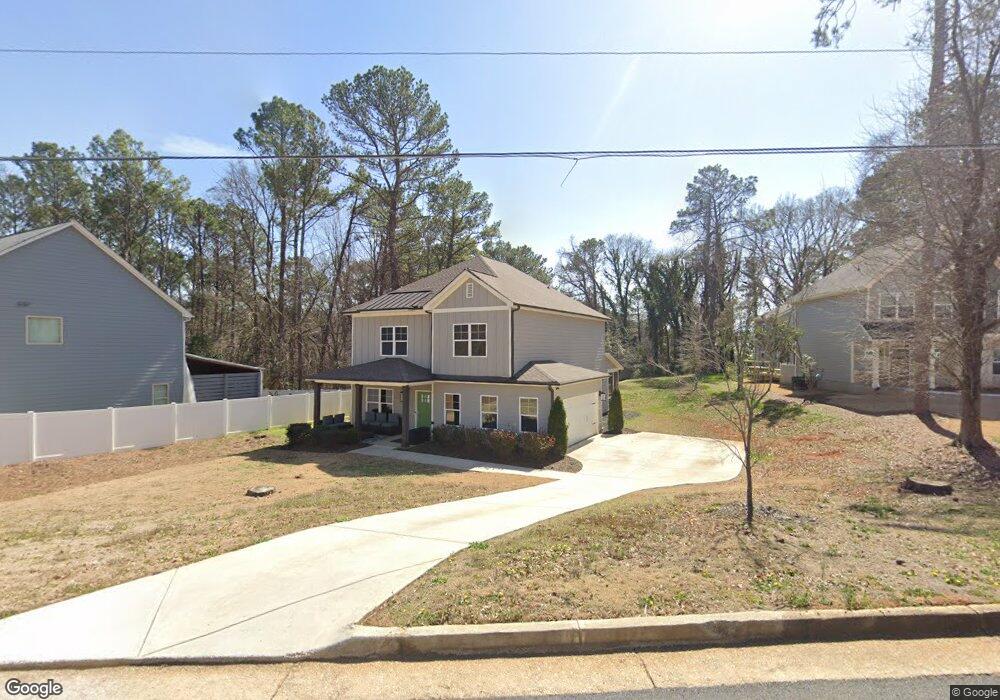
366 Pickfair Ave SW Atlanta, GA 30315
Lakewood Heights NeighborhoodEstimated Value: $404,350 - $493,000
4
Beds
3
Baths
2,300
Sq Ft
$189/Sq Ft
Est. Value
About This Home
This home is located at 366 Pickfair Ave SW, Atlanta, GA 30315 and is currently estimated at $434,588, approximately $188 per square foot. 366 Pickfair Ave SW is a home with nearby schools including Slater Elementary School, Price Middle School, and Carver High School.
Ownership History
Date
Name
Owned For
Owner Type
Purchase Details
Closed on
Apr 21, 2021
Sold by
Holiday Quay U
Bought by
Holiday Quay U and Denewton Edmond De
Current Estimated Value
Home Financials for this Owner
Home Financials are based on the most recent Mortgage that was taken out on this home.
Original Mortgage
$355,500
Outstanding Balance
$321,486
Interest Rate
3.1%
Mortgage Type
New Conventional
Estimated Equity
$113,102
Purchase Details
Closed on
Sep 12, 2019
Sold by
Faldon Salih Ttee
Bought by
Tlf Grp Llc
Create a Home Valuation Report for This Property
The Home Valuation Report is an in-depth analysis detailing your home's value as well as a comparison with similar homes in the area
Home Values in the Area
Average Home Value in this Area
Purchase History
| Date | Buyer | Sale Price | Title Company |
|---|---|---|---|
| Holiday Quay U | -- | -- | |
| Holiday Quay U | $395,000 | -- | |
| Tlf Grp Llc | $44,800 | -- |
Source: Public Records
Mortgage History
| Date | Status | Borrower | Loan Amount |
|---|---|---|---|
| Open | Holiday Quay U | $355,500 |
Source: Public Records
Tax History Compared to Growth
Tax History
| Year | Tax Paid | Tax Assessment Tax Assessment Total Assessment is a certain percentage of the fair market value that is determined by local assessors to be the total taxable value of land and additions on the property. | Land | Improvement |
|---|---|---|---|---|
| 2025 | $4,382 | $187,760 | $46,960 | $140,800 |
| 2023 | $5,687 | $137,360 | $32,680 | $104,680 |
| 2022 | $5,559 | $137,360 | $32,680 | $104,680 |
| 2021 | $4,096 | $101,120 | $31,720 | $69,400 |
| 2020 | $1,213 | $29,600 | $29,600 | $0 |
| 2019 | $430 | $27,240 | $27,240 | $0 |
| 2018 | $1,101 | $26,600 | $26,600 | $0 |
| 2017 | $719 | $16,640 | $16,640 | $0 |
| 2016 | $869 | $20,080 | $20,080 | $0 |
| 2015 | $982 | $20,080 | $20,080 | $0 |
| 2014 | -- | $20,080 | $20,080 | $0 |
Source: Public Records
Map
Nearby Homes
- 370 Ashwood Ave SW
- 545 Grant St SW
- 501 Grant St SW
- 1993 Reynolds Dr SW
- 372 Amal Dr SW
- 1752 Pryor Rd SW Unit 306
- 1985 Saint Johns Place
- 2025 Moody Dr SW
- 272 Hilltop Dr SW
- 245 Amal Dr SW Unit 2008
- 245 Amal Dr SW Unit 2018
- 245 Amal Dr SW
- 245 Amal Dr SW Unit 2010
- 2535 Lakewood Ave SW
- 109 Lakewood Way SW
- 0 Lakewood Way SW Unit 10606608
- 230 Amal Dr SW
- 230 Amal Dr SW Unit 212
- 273 Hipp St SW
- 0 Lakewood Ave SW Unit 7545893
- 356 Pickfair Ave SW
- 382 Pickfair Ave SW
- 415 Pickfair Ave SW
- 362 Pickfair Ave SW
- 392 Pickfair Ave SW
- 352 Pickfair Ave SW
- 371 Pickfair Ave SW
- 365 Pickfair Ave SW
- 377 Pickfair Ave SW
- 398 Pickfair Ave SW
- 357 Pickfair Ave SW
- 383 Pickfair Ave SW
- 0 Pickfair Ave SW Unit 8551728
- 0 Pickfair Ave SW Unit 8496583
- 0 Pickfair Ave SW Unit 8215351
- 0 Pickfair Ave SW Unit 8199986
- 0 Pickfair Ave SW Unit 3242243
- 0 Pickfair Ave SW Unit 3242241
- 0 Pickfair Ave SW Unit 3242238
- 0 Pickfair Ave SW Unit 3242240