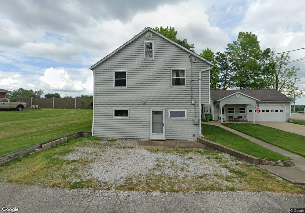
366 W State St Barberton, OH 44203
North Barberton NeighborhoodEstimated Value: $169,000 - $209,000
3
Beds
2
Baths
1,881
Sq Ft
$98/Sq Ft
Est. Value
About This Home
This home is located at 366 W State St, Barberton, OH 44203 and is currently estimated at $185,223, approximately $98 per square foot. 366 W State St is a home located in Summit County with nearby schools including Barberton Middle School, Barberton Intermediate School 3-5, and Barberton High School.
Ownership History
Date
Name
Owned For
Owner Type
Purchase Details
Closed on
Oct 31, 2019
Sold by
Powell Leonard D and Powell Cynthia
Bought by
Department Of Transportation
Current Estimated Value
Purchase Details
Closed on
Oct 16, 2017
Sold by
Powell Leonard D and Powell Cynthia
Bought by
The State Of Ohio
Purchase Details
Closed on
Jun 13, 2002
Sold by
Friedman David
Bought by
Powell Leonard D and Powell Cynthia
Create a Home Valuation Report for This Property
The Home Valuation Report is an in-depth analysis detailing your home's value as well as a comparison with similar homes in the area
Home Values in the Area
Average Home Value in this Area
Purchase History
| Date | Buyer | Sale Price | Title Company |
|---|---|---|---|
| Department Of Transportation | -- | None Available | |
| The State Of Ohio | -- | None Available | |
| Powell Leonard D | -- | -- |
Source: Public Records
Tax History Compared to Growth
Tax History
| Year | Tax Paid | Tax Assessment Tax Assessment Total Assessment is a certain percentage of the fair market value that is determined by local assessors to be the total taxable value of land and additions on the property. | Land | Improvement |
|---|---|---|---|---|
| 2025 | $1,989 | $48,868 | $11,736 | $37,132 |
| 2024 | $1,989 | $48,868 | $11,736 | $37,132 |
| 2023 | $1,989 | $48,868 | $11,736 | $37,132 |
| 2022 | $1,436 | $33,569 | $7,669 | $25,900 |
| 2021 | $1,434 | $33,569 | $7,669 | $25,900 |
| 2020 | $1,404 | $33,570 | $7,670 | $25,900 |
| 2019 | $1,549 | $30,010 | $6,430 | $23,580 |
| 2018 | $1,308 | $30,010 | $6,430 | $23,580 |
| 2017 | $1,325 | $30,010 | $6,430 | $23,580 |
| 2016 | $1,328 | $30,010 | $6,430 | $23,580 |
| 2015 | $1,325 | $30,010 | $6,430 | $23,580 |
| 2014 | $925 | $23,670 | $4,720 | $18,950 |
| 2013 | $959 | $24,780 | $4,720 | $20,060 |
Source: Public Records
Map
Nearby Homes
- 117 Fernwood Ave
- 103 & 103 1/2 Fernwood Ave
- 0 Romig Ave
- 1515 Grand Blvd
- 76 Hazelwood Ave
- 1150 Wooster Rd N
- 2714 Romig Rd
- 143 Glenn St
- 172 & 173 Belcher Ave
- 277 Glenn St
- 1453 Woodbirch Ave
- 818 N Summit St
- 1392 Belcher Ave
- 30 W Hiram St
- 137 Hermann St
- 146 Hermann St
- 1315 Kohler Ave
- 2518 30th St SW
- 1924 Caroline Ave
- 1295 Kohler Ave
- 366 W State St
- 374 W State St
- 356 W State St
- 183 Elmwood Ave
- 183 Elmwood Ave
- 183 Elmwood Ave
- 183 Elmwood Ave
- 183 Elmwood Ave
- 183 Elmwood Ave
- 183 Elmwood Ave
- 183 Elmwood Ave
- 183 Elmwood Ave
- 143 Elmwood Ave
- 377 W State St
- 154 Elmwood Ave
- 348 W State St
- 148 Elmwood Ave
- 381 W State St
- 345 W State St
- 191 Elmwood Ave