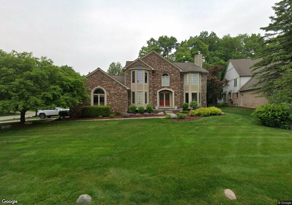
3662 Charlwood Dr Rochester Hills, MI 48306
Estimated Value: $617,072 - $706,000
4
Beds
3
Baths
3,188
Sq Ft
$209/Sq Ft
Est. Value
About This Home
This home is located at 3662 Charlwood Dr, Rochester Hills, MI 48306 and is currently estimated at $666,018, approximately $208 per square foot. 3662 Charlwood Dr is a home located in Oakland County with nearby schools including Musson Elementary School, Van Hoosen Middle School, and Rochester Adams High School.
Ownership History
Date
Name
Owned For
Owner Type
Purchase Details
Closed on
Aug 28, 2025
Sold by
Aouate Alan Keith
Bought by
Alan K Aouate Living Trust and Aouate
Current Estimated Value
Purchase Details
Closed on
Apr 10, 2025
Sold by
Aouate Alan Keith
Bought by
Aouate Lauren Elizabeth and Aouate Alan Keith
Purchase Details
Closed on
Aug 30, 2002
Sold by
Financi Cendant Mobility
Bought by
Aouate Alan K
Purchase Details
Closed on
Jan 21, 1999
Sold by
Jennings Roy A
Bought by
Cronizer Everett D
Purchase Details
Closed on
Apr 10, 1996
Sold by
Mccue James P
Bought by
Jennings Ray A
Home Financials for this Owner
Home Financials are based on the most recent Mortgage that was taken out on this home.
Original Mortgage
$236,400
Interest Rate
7.78%
Create a Home Valuation Report for This Property
The Home Valuation Report is an in-depth analysis detailing your home's value as well as a comparison with similar homes in the area
Home Values in the Area
Average Home Value in this Area
Purchase History
| Date | Buyer | Sale Price | Title Company |
|---|---|---|---|
| Alan K Aouate Living Trust | -- | None Listed On Document | |
| Aouate Lauren Elizabeth | -- | None Listed On Document | |
| Aouate Alan K | $381,000 | -- | |
| Cronizer Everett D | -- | -- | |
| Jennings Ray A | $295,500 | -- |
Source: Public Records
Mortgage History
| Date | Status | Borrower | Loan Amount |
|---|---|---|---|
| Previous Owner | Jennings Ray A | $236,400 |
Source: Public Records
Tax History Compared to Growth
Tax History
| Year | Tax Paid | Tax Assessment Tax Assessment Total Assessment is a certain percentage of the fair market value that is determined by local assessors to be the total taxable value of land and additions on the property. | Land | Improvement |
|---|---|---|---|---|
| 2022 | $2,947 | $211,460 | $0 | $0 |
| 2018 | $4,883 | $187,440 | $0 | $0 |
| 2017 | $4,786 | $185,180 | $0 | $0 |
| 2015 | -- | $174,670 | $0 | $0 |
| 2014 | -- | $158,850 | $0 | $0 |
| 2011 | -- | $135,750 | $0 | $0 |
Source: Public Records
Map
Nearby Homes
- 3640 Camden Ct
- 3634 Camden Ct
- 3674 Merriweather Ln
- 4035 Hillsdale Dr Unit 275
- 3534 Riverside Dr Unit 141
- 3633 Thornwood Dr
- 3879 Teakwood Ln
- 1906 Independence Ct
- 3273 Salem Dr
- 423 Silvervale Dr
- 5700 Rolling Hills Dr
- 1609 Kilburn Rd N
- 3095 Bridgewater Rd Unit 30
- 3780 Bald Mountain Rd
- 3057 Bridgewater Rd
- 2935 Woodford Cir
- 3639 Heatherwood Ct
- 2700 Mohawk Ln
- 5826 Murfield Dr
- 3111 Ramzi Ln
- 3656 Charlwood Dr
- 3289 Parkwood Dr
- 1579 Wakefield Dr
- 3283 Parkwood Dr
- 1587 Wakefield Dr
- 1595 Wakefield Dr
- 3663 Charlwood Dr
- 3650 Charlwood Dr
- 1493 Burhaven Dr
- 1485 Olympia Dr
- 3277 Parkwood Dr
- 3644 Charlwood Dr
- 1468 Olympia Dr
- 1603 Wakefield Ct
- 1481 Burhaven Dr Unit Bldg-Unit
- 1481 Burhaven Dr
- 1469 Olympia Dr
- 3271 Parkwood Dr
- 3290 Parkwood Dr
- 3638 Charlwood Dr