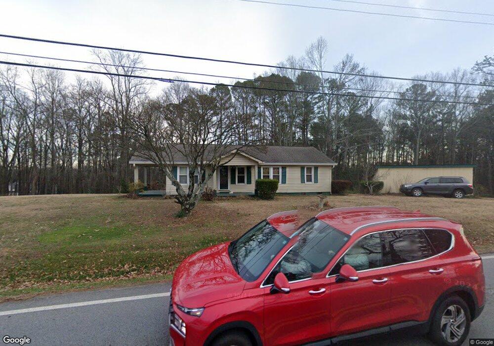
3671 S Bogan Rd Buford, GA 30519
Estimated Value: $223,000 - $335,000
2
Beds
1
Bath
1,134
Sq Ft
$231/Sq Ft
Est. Value
About This Home
This home is located at 3671 S Bogan Rd, Buford, GA 30519 and is currently estimated at $262,204, approximately $231 per square foot. 3671 S Bogan Rd is a home located in Gwinnett County with nearby schools including Buford Elementary School, Buford Senior Academy, and Buford Academy.
Ownership History
Date
Name
Owned For
Owner Type
Purchase Details
Closed on
Sep 20, 2019
Sold by
Griffin J A
Bought by
Mai Phuc and Nguyen H
Current Estimated Value
Home Financials for this Owner
Home Financials are based on the most recent Mortgage that was taken out on this home.
Original Mortgage
$70,000
Outstanding Balance
$53,609
Interest Rate
3.5%
Mortgage Type
New Conventional
Estimated Equity
$208,595
Purchase Details
Closed on
Nov 26, 2018
Sold by
Griffith J A
Bought by
Griffith J A and Richardson Jenna
Purchase Details
Closed on
Apr 28, 1993
Sold by
Puckett Hoyt A Betty
Bought by
Griffith J A Sheila
Home Financials for this Owner
Home Financials are based on the most recent Mortgage that was taken out on this home.
Original Mortgage
$44,000
Interest Rate
7.51%
Create a Home Valuation Report for This Property
The Home Valuation Report is an in-depth analysis detailing your home's value as well as a comparison with similar homes in the area
Home Values in the Area
Average Home Value in this Area
Purchase History
| Date | Buyer | Sale Price | Title Company |
|---|---|---|---|
| Mai Phuc | $130,000 | -- | |
| Griffith J A | -- | -- | |
| Griffith J A Sheila | $55,000 | -- |
Source: Public Records
Mortgage History
| Date | Status | Borrower | Loan Amount |
|---|---|---|---|
| Open | Mai Phuc | $70,000 | |
| Previous Owner | Griffith J A Sheila | $44,000 |
Source: Public Records
Tax History
| Year | Tax Paid | Tax Assessment Tax Assessment Total Assessment is a certain percentage of the fair market value that is determined by local assessors to be the total taxable value of land and additions on the property. | Land | Improvement |
|---|---|---|---|---|
| 2025 | $878 | $61,160 | $24,000 | $37,160 |
| 2024 | $878 | $61,160 | $24,000 | $37,160 |
| 2023 | $878 | $61,160 | $24,000 | $37,160 |
| 2022 | $631 | $44,000 | $14,000 | $30,000 |
| 2021 | $631 | $44,000 | $14,000 | $30,000 |
| 2020 | $631 | $44,000 | $14,000 | $30,000 |
| 2019 | $38 | $39,480 | $12,000 | $27,480 |
| 2018 | $38 | $39,480 | $12,000 | $27,480 |
| 2016 | $43 | $35,280 | $10,000 | $25,280 |
| 2015 | $44 | $35,280 | $10,000 | $25,280 |
| 2014 | $44 | $39,080 | $16,000 | $23,080 |
Source: Public Records
Map
Nearby Homes
- 2262 Silver Fox Ln
- 2140 Harvest Ridge Cir
- 2249 White Alder Dr
- 3843 Morning Meadow Ln
- 2380 Black Bear Ct
- 1970 Sturbridge Ln Unit 1
- 3534 Fallen Oak Ln
- 3503 Fallen Oak Dr
- 2151 E Maddox Rd
- 2727 Lost Mill Trace
- 2287 Tortuga Pass
- 3400 Coles Creek Dr
- 2190 Copper Trail Ln
- 3663 Lost Oak Dr
- 2148 Splitrail Trail
- 2275 Copper Trail Ln
- 2395 Kilgore Rd
- 2154 Millgate Ln NE
- 3685 Rolling Creek Dr
- 4041 Lost Mill Ln
- 3665 S Bogan Rd
- 3673 S Bogan Rd
- 3661 S Bogan Rd
- 3675 S Bogan Rd
- 3655 S Bogan Rd
- 3665 Heritage Crest Pkwy
- 3559 Silver Fox Path
- 3569 Silver Fox Path Unit 1
- 5305 Heritage Crest Pkwy
- 3725 Heritage Crest Pkwy
- 3654 Heritage Crest Pkwy
- 3715 Heritage Crest Pkwy
- 3735 Heritage Crest Pkwy
- 3685 Heritage Crest Pkwy
- 3664 Heritage Crest Pkwy
- 3539 Silver Fox Path Unit 1
- 3705 Heritage Crest Pkwy
- 3579 Silver Fox Path
- 3529 Silver Fox Path Unit 1
- 2120 Kilgore Rd
Your Personal Tour Guide
Ask me questions while you tour the home.