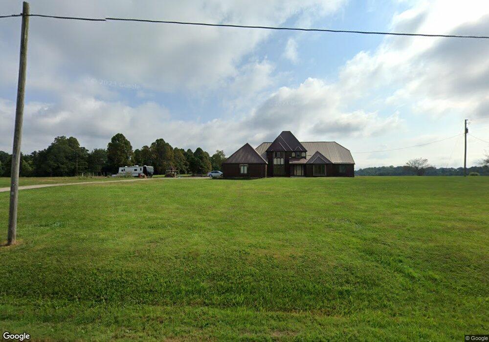
368 E State Route 266 Stockport, OH 43787
Estimated Value: $223,000 - $479,141
3
Beds
3
Baths
4,011
Sq Ft
$95/Sq Ft
Est. Value
About This Home
This home is located at 368 E State Route 266, Stockport, OH 43787 and is currently estimated at $382,047, approximately $95 per square foot. 368 E State Route 266 is a home with nearby schools including Fort Frye High School.
Ownership History
Date
Name
Owned For
Owner Type
Purchase Details
Closed on
Oct 3, 2017
Sold by
Simmons Gary Jon and Simmons Tina
Bought by
Voland Leslie P and Voland Dawn Michelle
Current Estimated Value
Purchase Details
Closed on
Oct 27, 2015
Sold by
Voland Leslie P and Voland Dawn Michelle
Bought by
Simmons Gary Jon and Simmons Tina
Home Financials for this Owner
Home Financials are based on the most recent Mortgage that was taken out on this home.
Original Mortgage
$289,000
Interest Rate
3.87%
Mortgage Type
Purchase Money Mortgage
Create a Home Valuation Report for This Property
The Home Valuation Report is an in-depth analysis detailing your home's value as well as a comparison with similar homes in the area
Home Values in the Area
Average Home Value in this Area
Purchase History
| Date | Buyer | Sale Price | Title Company |
|---|---|---|---|
| Voland Leslie P | -- | None Available | |
| Simmons Gary Jon | $289,000 | None Available |
Source: Public Records
Mortgage History
| Date | Status | Borrower | Loan Amount |
|---|---|---|---|
| Previous Owner | Simmons Gary Jon | $289,000 |
Source: Public Records
Tax History Compared to Growth
Tax History
| Year | Tax Paid | Tax Assessment Tax Assessment Total Assessment is a certain percentage of the fair market value that is determined by local assessors to be the total taxable value of land and additions on the property. | Land | Improvement |
|---|---|---|---|---|
| 2024 | $4,365 | $144,920 | $8,000 | $136,920 |
| 2023 | $2,911 | $99,670 | $6,520 | $93,150 |
| 2022 | $2,928 | $99,670 | $6,520 | $93,150 |
| 2021 | $2,956 | $99,670 | $6,520 | $93,150 |
| 2019 | $2,721 | $88,770 | $5,930 | $82,840 |
| 2018 | $2,616 | $88,770 | $5,930 | $82,840 |
| 2017 | $3,305 | $96,093 | $5,117 | $90,976 |
| 2016 | $3,313 | $96,093 | $5,117 | $90,976 |
Source: Public Records
Map
Nearby Homes
- 1550 Swift Rd
- 5855 Olney Run Rd
- 1240 Hayesville Rd
- 3130 Ohio 266
- 3439 Columbus St
- 6 Spring St
- 21870 State Route 339
- 590 Stony Run Rd
- 200 Pennock Dr Unit Lot 37
- 4 Center St
- 5 Center St
- 717 Mitchell Ave
- 3 Center St
- 0 Ohio 339
- 2444 Ervin Ln
- 500 Applegate Dr
- 2712 Sycamore Ln
- 0 Ogles Ridge Rd Unit 11570286
- 3707 Righteous Ridge Rd
- 3020 State Route 376
- 150 Ohio 266
- 370 S State Route 266 SE
- 150 State Route 266
- 6333 Cooper Ln
- 150 N State Route 266
- 140 Buckeye Dr
- 6005 E State Route 60 NE
- 6005 S R 60
- 6005 S State Route 60
- 290 S State Route 266 SE
- 280 S R 266
- 320 S State Route 266 SE
- 5950 E State Route 60 NE
- 5950 E State Route 60 NE
- 0 Buckeye Dr Unit 8 & 9 3989808
- 0 Buckeye Dr Unit Lot 6 3989138
- 0 Buckeye Dr Unit 3989808
- 320 Buckeye Dr
- 5800 E State Route 60 NE
- 5757 E State Route 60 NE