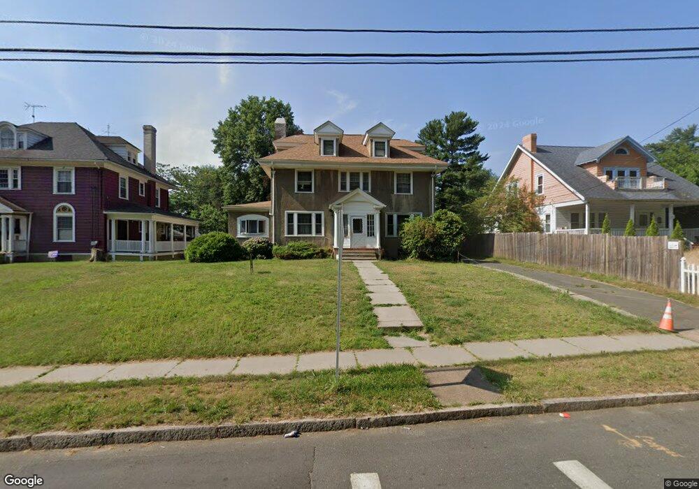
368 Edgewood St Hartford, CT 06112
North End NeighborhoodEstimated Value: $230,162 - $352,000
6
Beds
2
Baths
2,569
Sq Ft
$120/Sq Ft
Est. Value
About This Home
This home is located at 368 Edgewood St, Hartford, CT 06112 and is currently estimated at $308,791, approximately $120 per square foot. 368 Edgewood St is a home located in Hartford County with nearby schools including Rawson School, Noah Webster Micro Society School, and McKinley School.
Ownership History
Date
Name
Owned For
Owner Type
Purchase Details
Closed on
Jul 29, 1997
Sold by
Durrant Samuel and Durrant Doris
Bought by
Frazier Herert and Frazier Lillie
Current Estimated Value
Home Financials for this Owner
Home Financials are based on the most recent Mortgage that was taken out on this home.
Original Mortgage
$85,500
Outstanding Balance
$12,470
Interest Rate
7.7%
Mortgage Type
Purchase Money Mortgage
Estimated Equity
$296,321
Create a Home Valuation Report for This Property
The Home Valuation Report is an in-depth analysis detailing your home's value as well as a comparison with similar homes in the area
Home Values in the Area
Average Home Value in this Area
Purchase History
| Date | Buyer | Sale Price | Title Company |
|---|---|---|---|
| Frazier Herert | $95,000 | -- |
Source: Public Records
Mortgage History
| Date | Status | Borrower | Loan Amount |
|---|---|---|---|
| Open | Frazier Herert | $85,500 |
Source: Public Records
Tax History Compared to Growth
Tax History
| Year | Tax Paid | Tax Assessment Tax Assessment Total Assessment is a certain percentage of the fair market value that is determined by local assessors to be the total taxable value of land and additions on the property. | Land | Improvement |
|---|---|---|---|---|
| 2025 | $4,379 | $63,504 | $5,843 | $57,661 |
| 2024 | $4,379 | $63,504 | $5,843 | $57,661 |
| 2023 | $4,379 | $63,504 | $5,843 | $57,661 |
| 2022 | $4,379 | $63,504 | $5,843 | $57,661 |
| 2021 | $3,458 | $46,550 | $5,110 | $41,440 |
| 2020 | $3,458 | $46,550 | $5,110 | $41,440 |
| 2019 | $3,458 | $46,550 | $5,110 | $41,440 |
| 2018 | $3,342 | $44,981 | $4,938 | $40,043 |
| 2016 | $3,467 | $46,672 | $4,702 | $41,970 |
| 2015 | $3,303 | $44,455 | $4,479 | $39,976 |
| 2014 | $3,222 | $43,369 | $4,370 | $38,999 |
Source: Public Records
Map
Nearby Homes
- 87 Mansfield St Unit 89
- 59 Mansfield St Unit 61
- 50 Mansfield St
- 33 E Raymond St Unit 35
- 238 Enfield St Unit 240
- 147 Enfield St Unit 149
- 275 Westland St
- 141 Greenfield St
- 551 Garden St Unit 553
- 37 Martin St
- 67 Enfield St Unit 37
- 68 Enfield St Unit 70
- 158 Martin St Unit 160
- 109 Blue Hills Ave
- 4 Deerfield Ave
- 134 Magnolia St Unit 136
- 25 Judson St Unit C
- 131-135,137-145,119- Albany Ave
- 183 Brook St Unit 185
- 410 Garden St
- 364 Edgewood St
- 374 Edgewood St
- 376 Edgewood St
- 352 Edgewood St
- 342 Edgewood St
- 338 Edgewood St
- 24 Keney Terrace
- 28 Keney Terrace
- 263 Vine St
- 267 Vine St
- 18 Keney Terrace
- 259 Vine St
- 34 Keney Terrace
- 255 Vine St
- 332 Edgewood St
- 271 Vine St
- 324 Edgewood St
- 262 Vine St Unit 16
- 262 Vine St Unit 21
- 262 Vine St Unit 17