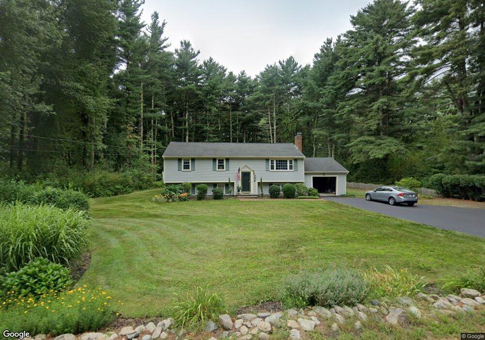
368 Main St Hanover, MA 02339
Estimated Value: $645,000 - $861,000
4
Beds
2
Baths
1,196
Sq Ft
$623/Sq Ft
Est. Value
About This Home
This home is located at 368 Main St, Hanover, MA 02339 and is currently estimated at $745,363, approximately $623 per square foot. 368 Main St is a home located in Plymouth County with nearby schools including Hanover High School, The Master's Academy, and Cardinal Cushing Centers.
Ownership History
Date
Name
Owned For
Owner Type
Purchase Details
Closed on
Mar 27, 2014
Sold by
Barry Mark E and Barry Sheila T
Bought by
Barry
Current Estimated Value
Purchase Details
Closed on
Oct 16, 1995
Sold by
Comer Mary E and Comer Joan T
Bought by
Barry Mark E and Barry Sheila T
Purchase Details
Closed on
Mar 6, 1991
Sold by
Mccarthy John P and Mccarthy Carolyn M
Bought by
Comer Mary E and Comer Joan T
Create a Home Valuation Report for This Property
The Home Valuation Report is an in-depth analysis detailing your home's value as well as a comparison with similar homes in the area
Home Values in the Area
Average Home Value in this Area
Purchase History
| Date | Buyer | Sale Price | Title Company |
|---|---|---|---|
| Barry | -- | -- | |
| Barry | -- | -- | |
| Barry Mark E | $184,000 | -- | |
| Barry Mark E | $184,000 | -- | |
| Comer Mary E | $150,000 | -- | |
| Comer Mary E | $150,000 | -- |
Source: Public Records
Mortgage History
| Date | Status | Borrower | Loan Amount |
|---|---|---|---|
| Previous Owner | Comer Mary E | $143,000 | |
| Previous Owner | Comer Mary E | $166,000 |
Source: Public Records
Tax History Compared to Growth
Tax History
| Year | Tax Paid | Tax Assessment Tax Assessment Total Assessment is a certain percentage of the fair market value that is determined by local assessors to be the total taxable value of land and additions on the property. | Land | Improvement |
|---|---|---|---|---|
| 2025 | $8,481 | $686,700 | $325,000 | $361,700 |
| 2024 | $8,490 | $661,200 | $325,000 | $336,200 |
| 2023 | $8,340 | $618,200 | $295,300 | $322,900 |
| 2022 | $7,851 | $514,800 | $246,100 | $268,700 |
| 2021 | $7,567 | $463,400 | $223,800 | $239,600 |
| 2020 | $7,490 | $459,200 | $223,800 | $235,400 |
| 2019 | $6,989 | $425,900 | $223,800 | $202,100 |
| 2018 | $6,943 | $426,500 | $223,800 | $202,700 |
| 2017 | $6,831 | $413,500 | $233,700 | $179,800 |
| 2016 | $6,614 | $392,300 | $212,500 | $179,800 |
| 2015 | $6,098 | $377,600 | $231,800 | $145,800 |
Source: Public Records
Map
Nearby Homes
- 62 Larchmont Ln
- 116 Spring Meadow Ln
- 8 Old Farm Rd
- 265 Silver St
- 250 Center St
- 51 Cervelli Farm Dr
- 37 Dr
- 23 Cervelli Farm Dr
- 38 Cervelli Farm Dr
- 9 Cervelli Farm Dr
- 118 Bates Way
- 53 Chestnut St
- 14 Longwood Ln Unit 14
- 70 Dillingham Way
- 436 Center St
- 67 School St
- 21 King St
- 276 Woodland Dr
- 154 Winter St
- 216 Whiting St