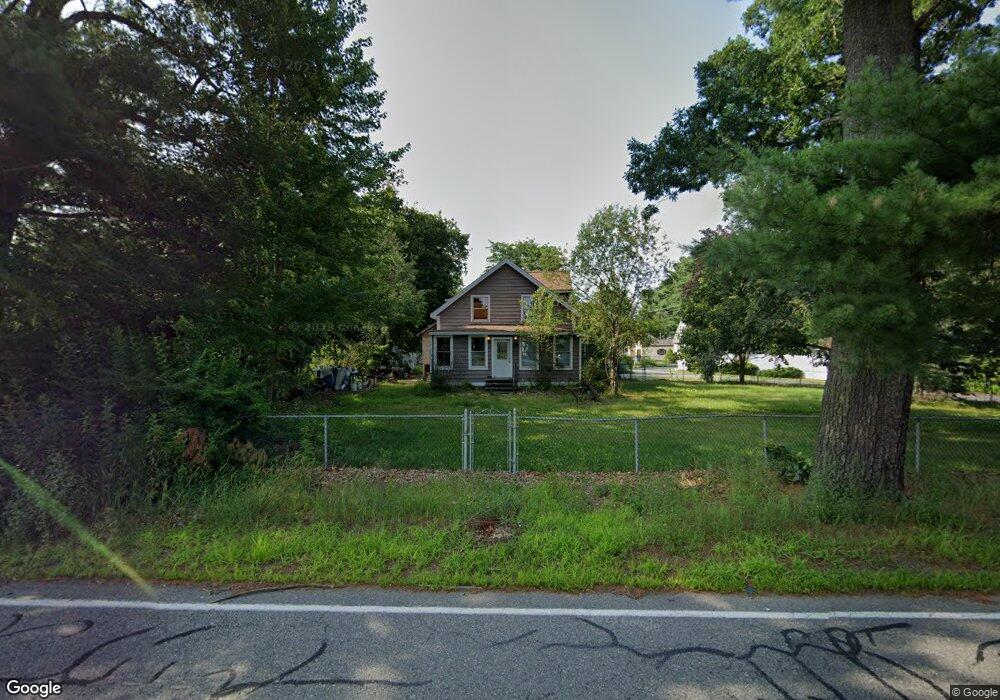
368 Shawsheen St Tewksbury, MA 01876
Estimated Value: $620,000 - $733,000
3
Beds
2
Baths
2,040
Sq Ft
$336/Sq Ft
Est. Value
About This Home
This home is located at 368 Shawsheen St, Tewksbury, MA 01876 and is currently estimated at $686,307, approximately $336 per square foot. 368 Shawsheen St is a home located in Middlesex County with nearby schools including Heath-Brook Elementary School.
Ownership History
Date
Name
Owned For
Owner Type
Purchase Details
Closed on
Dec 15, 2023
Sold by
Turcotte Raymond L
Bought by
Raymond L Turcotte Irt and Turcotte
Current Estimated Value
Purchase Details
Closed on
Jun 11, 2020
Sold by
Turcotte Peter A
Bought by
Peter A Turcotte Sr Irt and Turcotte
Create a Home Valuation Report for This Property
The Home Valuation Report is an in-depth analysis detailing your home's value as well as a comparison with similar homes in the area
Home Values in the Area
Average Home Value in this Area
Purchase History
| Date | Buyer | Sale Price | Title Company |
|---|---|---|---|
| Raymond L Turcotte Irt | -- | None Available | |
| Raymond L Turcotte Irt | -- | None Available | |
| Turcotte Raymond L | -- | None Available | |
| Peter A Turcotte Sr Irt | -- | None Available | |
| Peter A Turcotte Sr Irt | -- | None Available |
Source: Public Records
Tax History Compared to Growth
Tax History
| Year | Tax Paid | Tax Assessment Tax Assessment Total Assessment is a certain percentage of the fair market value that is determined by local assessors to be the total taxable value of land and additions on the property. | Land | Improvement |
|---|---|---|---|---|
| 2025 | $7,431 | $562,100 | $284,600 | $277,500 |
| 2024 | $7,347 | $548,700 | $271,200 | $277,500 |
| 2023 | $7,047 | $499,800 | $246,500 | $253,300 |
| 2022 | $6,705 | $441,100 | $214,300 | $226,800 |
| 2021 | $0 | $379,200 | $194,900 | $184,300 |
| 2020 | $5,767 | $361,100 | $185,500 | $175,600 |
| 2019 | $0 | $336,300 | $176,600 | $159,700 |
| 2018 | $5,420 | $336,000 | $176,600 | $159,400 |
| 2017 | $5,010 | $307,200 | $176,600 | $130,600 |
| 2016 | $5,000 | $305,800 | $176,600 | $129,200 |
| 2015 | $4,685 | $286,200 | $171,400 | $114,800 |
| 2014 | $4,472 | $277,600 | $171,400 | $106,200 |
Source: Public Records
Map
Nearby Homes
- 364 Shawsheen St
- 5 Knollwood Rd
- 358 Shawsheen St
- 6 Knollwood Rd
- 390 Shawsheen St
- 7 Knollwood Rd
- 356 Shawsheen St
- 373 Shawsheen St
- 363 Shawsheen St
- 350 Shawsheen St
- 8 Knollwood Rd
- 121 Patricia Dr
- 394 Shawsheen St
- 381 Shawsheen St
- 353 Shawsheen St
- 9 Knollwood Rd
- 3 Charlotte Rd
- 131 Patricia Dr
- 10 Knollwood Rd
- 4 Revere Rd