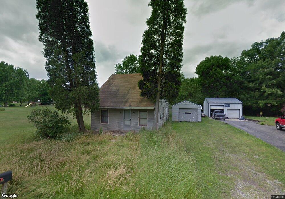
3680 Homewood Ave Hubbard, OH 44425
Estimated Value: $137,000
3
Beds
1
Bath
1,152
Sq Ft
$119/Sq Ft
Est. Value
About This Home
This home is located at 3680 Homewood Ave, Hubbard, OH 44425 and is currently estimated at $137,000, approximately $118 per square foot. 3680 Homewood Ave is a home located in Trumbull County with nearby schools including Hubbard Elementary School, Hubbard Middle School, and Hubbard High School.
Ownership History
Date
Name
Owned For
Owner Type
Purchase Details
Closed on
Jan 23, 2018
Sold by
Trumbull County Land Reutilization Corp
Bought by
Walters Christopher F and Walters Sandy L
Current Estimated Value
Purchase Details
Closed on
Nov 21, 2016
Sold by
Hassey Robert
Bought by
Trumbull County Land Reutilization
Home Financials for this Owner
Home Financials are based on the most recent Mortgage that was taken out on this home.
Interest Rate
3.94%
Purchase Details
Closed on
Jan 1, 1990
Bought by
Robert Hassey
Create a Home Valuation Report for This Property
The Home Valuation Report is an in-depth analysis detailing your home's value as well as a comparison with similar homes in the area
Home Values in the Area
Average Home Value in this Area
Purchase History
| Date | Buyer | Sale Price | Title Company |
|---|---|---|---|
| Walters Christopher F | -- | None Available | |
| Trumbull County Land Reutilization | -- | -- | |
| Robert Hassey | -- | -- |
Source: Public Records
Mortgage History
| Date | Status | Borrower | Loan Amount |
|---|---|---|---|
| Previous Owner | Trumbull County Land Reutilization | -- |
Source: Public Records
Tax History Compared to Growth
Tax History
| Year | Tax Paid | Tax Assessment Tax Assessment Total Assessment is a certain percentage of the fair market value that is determined by local assessors to be the total taxable value of land and additions on the property. | Land | Improvement |
|---|---|---|---|---|
| 2024 | $77 | $880 | $880 | $0 |
| 2023 | $77 | $880 | $880 | $0 |
| 2022 | $83 | $880 | $880 | $0 |
| 2021 | $83 | $880 | $880 | $0 |
| 2020 | $84 | $880 | $880 | $0 |
| 2019 | $87 | $880 | $880 | $0 |
| 2018 | $535 | $7,560 | $1,750 | $5,810 |
| 2017 | $533 | $7,560 | $1,750 | $5,810 |
| 2016 | $622 | $9,560 | $1,510 | $8,050 |
| 2015 | $624 | $9,560 | $1,510 | $8,050 |
| 2014 | $613 | $9,560 | $1,510 | $8,050 |
| 2013 | $637 | $9,980 | $1,510 | $8,470 |
Source: Public Records
Map
Nearby Homes
- 5843 Fairlawn Ave
- 6068 Evans Dr
- 3317 Beechwood Dr
- 3234 Bell Wick Rd
- 2160 Lansdowne Blvd
- 366 Westview Ave
- 3275 Beechwood Dr
- 0 Homestead Rd
- 3943 Logangate Rd
- V/L Jacobs Rd
- 257 Westview Ave
- 3502 Somerset Dr Unit B
- 2010 Powder Mill Run
- 0 Powder Mill Run Unit 5127327
- 0 Powder Mill Run Unit 5127333
- 2012 Crestwood Blvd
- 2021 Crestwood Blvd
- 1720 Jacobs Rd
- 124 Rebecca Ave
- 2831 Benford Ln
- 3670 Homewood Ave
- 3686 Homewood Ave
- 3660 Homewood Ave
- 3685 Homewood Ave
- 3687 Franklin Ave
- 3665 Franklin Ave
- 3652 Homewood Ave
- 3668 Orchard Ave
- 3646 Homewood Ave
- 3653 Franklin Ave
- 3692 Orchard Ave
- 3692 Orchard Ave
- 3670 Franklin Ave
- 3651 Homewood Ave
- 5958 Lawnview Ave
- 3704 Orchard Ave
- 5988 Lawnview Ave
- 5929 Lawnview Ave
- 3648 Franklin Ave
- 3635 Homewood Ave