Estimated Value: $150,000 - $242,053
4
Beds
2
Baths
1,750
Sq Ft
$120/Sq Ft
Est. Value
About This Home
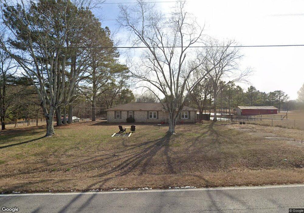
This home is located at 3686 Simpson Point Rd, Grant, AL 35747 and is currently estimated at $209,263, approximately $119 per square foot. 3686 Simpson Point Rd is a home located in Marshall County with nearby schools including Kate Duncan Smith DAR Elementary School, Kate Duncan Smith DAR Middle School, and Kate Duncan Smith DAR High School.
Ownership History
Date
Name
Owned For
Owner Type
Purchase Details
Closed on
Sep 18, 2007
Sold by
Choat Martha Louise and Estate Of Doyle R Choat
Bought by
Neu Herbert S and Reynolds Neu Sasha
Current Estimated Value
Home Financials for this Owner
Home Financials are based on the most recent Mortgage that was taken out on this home.
Original Mortgage
$60,000
Outstanding Balance
$37,832
Interest Rate
6.49%
Mortgage Type
New Conventional
Estimated Equity
$171,431
Purchase Details
Closed on
May 23, 2005
Sold by
Moore Thomas and Moore Doris
Bought by
Choat Doyle R
Home Financials for this Owner
Home Financials are based on the most recent Mortgage that was taken out on this home.
Original Mortgage
$46,400
Interest Rate
5.75%
Mortgage Type
Adjustable Rate Mortgage/ARM
Create a Home Valuation Report for This Property
The Home Valuation Report is an in-depth analysis detailing your home's value as well as a comparison with similar homes in the area
Purchase History
| Date | Buyer | Sale Price | Title Company |
|---|---|---|---|
| Neu Herbert S | -- | None Available | |
| Choat Doyle R | $58,000 | None Available |
Source: Public Records
Mortgage History
| Date | Status | Borrower | Loan Amount |
|---|---|---|---|
| Open | Neu Herbert S | $60,000 | |
| Closed | Choat Doyle R | $46,400 |
Source: Public Records
Tax History
| Year | Tax Paid | Tax Assessment Tax Assessment Total Assessment is a certain percentage of the fair market value that is determined by local assessors to be the total taxable value of land and additions on the property. | Land | Improvement |
|---|---|---|---|---|
| 2024 | $561 | $15,920 | $0 | $0 |
| 2023 | $527 | $15,660 | $660 | $15,000 |
| 2022 | $0 | $12,080 | $0 | $0 |
| 2021 | $5 | $11,500 | $0 | $0 |
| 2020 | $6 | $9,400 | $0 | $0 |
| 2017 | $0 | $8,800 | $0 | $0 |
| 2015 | -- | $8,460 | $0 | $0 |
| 2014 | -- | $8,460 | $0 | $0 |
Source: Public Records
Map
Nearby Homes
- 3219 Simpson Point Rd
- 15 Shin Point Rd
- 1169 Honeycomb Rd
- 1821 Simpson Point Rd
- 288 Eleven Forty Rd
- 2216 White Elephant Rd
- .80 Honeycomb Rd
- Lot 5 White Elephant Rd
- 1885 White Elephant Rd
- 131 Winter Dr
- 1520 White Elephant Rd
- .57 acre Shelby Dr
- 0 Honeycomb Rd Unit RTC3071170
- 0 Honeycomb Rd Unit 522693
- 27590 Us Highway 431
- 89 Bearden Dr
- 28537 US Highway 431 Unit 22
- 28527 Us Highway 431
- 28513 US Highway 431
- 7905 Simpson Point Rd
- 3648 Simpson Point Rd
- 3729 Simpson Point Rd
- 3707 Simpson Point Rd
- 3669 Simpson Point Rd
- 3764 Simpson Point Rd
- 3770 Simpson Point Rd
- 3846 Simpson Point Rd
- 3819 Simpson Point Rd
- 3808 Simpson Point Rd
- 25 Brewer Cir
- 3495 Simpson Point Rd
- 52 Brewer Cir
- 00 Tina Ln
- 000 Tina Ln
- 3476 Simpson Point Rd
- 191 Tina Ln
- 3958 Simpson Point Rd
- 4019 Simpson Point Rd
- 4019 Simpson Point Rd
- 3996 Simpson Point Rd
Your Personal Tour Guide
Ask me questions while you tour the home.