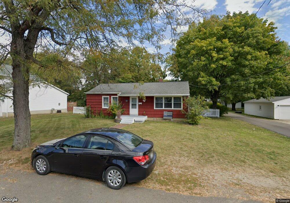
369 Madison St Plain City, OH 43064
Estimated Value: $188,166 - $250,000
2
Beds
1
Bath
960
Sq Ft
$226/Sq Ft
Est. Value
About This Home
This home is located at 369 Madison St, Plain City, OH 43064 and is currently estimated at $217,292, approximately $226 per square foot. 369 Madison St is a home located in Madison County with nearby schools including Plain City Elementary School, Jonathan Alder Junior High School, and Canaan Middle School.
Ownership History
Date
Name
Owned For
Owner Type
Purchase Details
Closed on
Dec 30, 2019
Sold by
Estate Of Jerry D May
Bought by
May Kathy M
Current Estimated Value
Purchase Details
Closed on
Oct 21, 2016
Sold by
May Jerry
Bought by
May Jerry
Purchase Details
Closed on
Dec 5, 2012
Sold by
May Zelma
Bought by
May Jerry and Zelma May Revocable Trust
Purchase Details
Closed on
Aug 28, 2000
Sold by
Prochaska David M
Bought by
May Carson and May Zelma
Create a Home Valuation Report for This Property
The Home Valuation Report is an in-depth analysis detailing your home's value as well as a comparison with similar homes in the area
Home Values in the Area
Average Home Value in this Area
Purchase History
| Date | Buyer | Sale Price | Title Company |
|---|---|---|---|
| May Kathy M | -- | None Available | |
| May Jerry | -- | Attorney | |
| May Jerry | -- | Attorney | |
| May Carson | $75,000 | -- |
Source: Public Records
Tax History Compared to Growth
Tax History
| Year | Tax Paid | Tax Assessment Tax Assessment Total Assessment is a certain percentage of the fair market value that is determined by local assessors to be the total taxable value of land and additions on the property. | Land | Improvement |
|---|---|---|---|---|
| 2024 | $1,906 | $42,470 | $15,900 | $26,570 |
| 2023 | $1,906 | $42,470 | $15,900 | $26,570 |
| 2022 | $1,597 | $32,260 | $12,080 | $20,180 |
| 2021 | $1,637 | $32,260 | $12,080 | $20,180 |
| 2020 | $1,657 | $32,260 | $12,080 | $20,180 |
| 2019 | $1,356 | $27,340 | $11,820 | $15,520 |
| 2018 | $1,382 | $27,340 | $11,820 | $15,520 |
| 2017 | $1,281 | $27,340 | $11,820 | $15,520 |
| 2016 | $1,281 | $24,460 | $11,820 | $12,640 |
| 2015 | $1,295 | $24,460 | $11,820 | $12,640 |
| 2014 | $1,229 | $24,460 | $11,820 | $12,640 |
| 2013 | -- | $28,990 | $9,980 | $19,010 |
Source: Public Records
Map
Nearby Homes
- 180 Jackson St
- 107 Jackson Blvd
- 146 E Main St Unit 160
- 2 Surrey Ct
- 8624 Martin Ln
- 403 Coachman Dr
- 650 Carriage Dr
- 306 Red Knot Ct
- 2053 Slippery Rail Dr
- 1424 Sand Dome Way
- Granville Plan at Darby Station - Premier
- Hudson Plan at Darby Station - Premier
- Farm Plan at Darby Station - Premier
- Caymus Plan at Darby Station - Premier
- Bucknell Plan at Darby Station - Signature
- Vanderbilt Plan at Darby Station - Signature
- Citadel Plan at Darby Station - Signature
- Dearborn Plan at Darby Station - Smart Essentials Collection
- Wesleyan Plan at Darby Station - Signature
- Ellman Plan at Darby Station - Premier
- 367 Madison St
- 131 E South Ave
- 382 Madison St
- 150 E South Ave
- 359 Madison St
- 382 Central Ave
- 368 Madison St
- 356 Central Ave
- 113 E South Ave
- 351 Madison St
- 350 Central Ave
- 354 Madison St
- 375 Central Ave
- 369 Central Ave
- 343 Madison St
- 375 S Chillicothe St
- 365 Central Ave
- 371 S Chillicothe St
- 151 E South Ave
- 367 S Chillicothe St