Estimated Value: $159,199 - $267,000
--
Bed
1
Bath
1,470
Sq Ft
$146/Sq Ft
Est. Value
About This Home
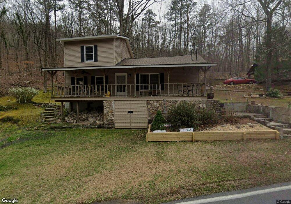
This home is located at 369 Radio Springs Rd SW, Rome, GA 30165 and is currently estimated at $214,800, approximately $146 per square foot. 369 Radio Springs Rd SW is a home located in Floyd County with nearby schools including Coosa Middle School and Coosa High School.
Ownership History
Date
Name
Owned For
Owner Type
Purchase Details
Closed on
Jul 6, 2001
Sold by
Frost Michael T
Bought by
Ayers Danny E
Current Estimated Value
Purchase Details
Closed on
Apr 6, 1998
Sold by
Frost Donald Lane and Kathy Lynn Frost
Bought by
Frost Michael T
Purchase Details
Closed on
Mar 16, 1984
Sold by
Childress Thomas Mr and Childress Mrs
Bought by
Frost Donald Lane and Kathy Lynn Fros
Purchase Details
Closed on
Dec 6, 1983
Sold by
Parker Ronald W
Bought by
Childress Thomas Mr and Childress Mrs
Purchase Details
Closed on
Feb 8, 1979
Sold by
Parker Ronald W and Parker Suzanne
Bought by
Parker Ronald W
Purchase Details
Closed on
Oct 3, 1977
Sold by
Childress Thomas A
Bought by
Parker Ronald W and Parker Suzanne
Purchase Details
Closed on
Jan 1, 1966
Bought by
Childress Thomas A
Create a Home Valuation Report for This Property
The Home Valuation Report is an in-depth analysis detailing your home's value as well as a comparison with similar homes in the area
Home Values in the Area
Average Home Value in this Area
Purchase History
| Date | Buyer | Sale Price | Title Company |
|---|---|---|---|
| Ayers Danny E | $39,200 | -- | |
| Frost Michael T | $50,000 | -- | |
| Frost Donald Lane | $21,000 | -- | |
| Childress Thomas Mr | $4,000 | -- | |
| Parker Ronald W | -- | -- | |
| Parker Ronald W | $12,000 | -- | |
| Childress Thomas A | $900 | -- |
Source: Public Records
Tax History Compared to Growth
Tax History
| Year | Tax Paid | Tax Assessment Tax Assessment Total Assessment is a certain percentage of the fair market value that is determined by local assessors to be the total taxable value of land and additions on the property. | Land | Improvement |
|---|---|---|---|---|
| 2024 | $962 | $52,751 | $10,349 | $42,402 |
| 2023 | $966 | $51,027 | $9,408 | $41,619 |
| 2022 | $562 | $27,434 | $7,738 | $19,696 |
| 2021 | $496 | $23,502 | $7,051 | $16,451 |
| 2020 | $464 | $21,579 | $6,131 | $15,448 |
| 2019 | $423 | $19,523 | $6,131 | $13,392 |
| 2018 | $399 | $18,173 | $5,839 | $12,334 |
| 2017 | $383 | $17,199 | $5,407 | $11,792 |
| 2016 | $380 | $16,802 | $5,400 | $11,402 |
| 2015 | $375 | $16,802 | $5,400 | $11,402 |
| 2014 | $375 | $16,802 | $5,400 | $11,402 |
Source: Public Records
Map
Nearby Homes
- 0 Mt Alto Rd Sw Lot Unit WP001
- 0 Radio Springs Rd SW Unit 10587646
- 0 Radio Springs Rd SW Unit 10587644
- 0 Radio Springs Rd SW Unit 10587642
- 4 Rivermont Dr SW
- 30 Fairview Dr SW
- 10 Horseshoe Bend Rd SW
- 10 Rivermont Dr SW
- 2 Kensington Rd SW
- 1 Windsor Rd SW
- 3241 Horseleg Creek Rd SW
- 248 Smith Rd SW
- 1 Huntington Rd SW
- 99 Janie Beth Dr SW
- 0 Belle Meade Dr SW Unit 10504645
- 3428 Horseleg Creek Rd SW
- 11 Brow Rd SW
- 27 Stonebrook Dr SW
- 0 Hidden Ridge Dr Unit 10556470
- 0 Hidden Ridge Dr Unit 10343706
- 369 Radio Springs Rd SW
- 369 Radio Springs Rd SW
- 413 Radio Springs Rd SW
- 413 Radio Springs Rd SW
- 413 Radio Springs Rd SW
- 372 Radio Springs Rd SW
- 372 Radio Springs Rd SW
- 372 Radio Springs Rd SW
- 372 Radio Springs Rd SW
- 372 Radio Springs Rd SW
- 372 Radio Springs Rd SW
- 372 Radio Springs Rd SW
- 404 Radio Springs Rd SW
- 404 Radio Springs Rd SW
- 426 Radio Springs Rd SW
- 436 Radio Springs Rd SW
- 436 Radio Springs Rd SW
- 3 Spring Mountain Rd
- 2 Spring Mountain Rd
- 0 Floyd Springs Rd Unit 7308667