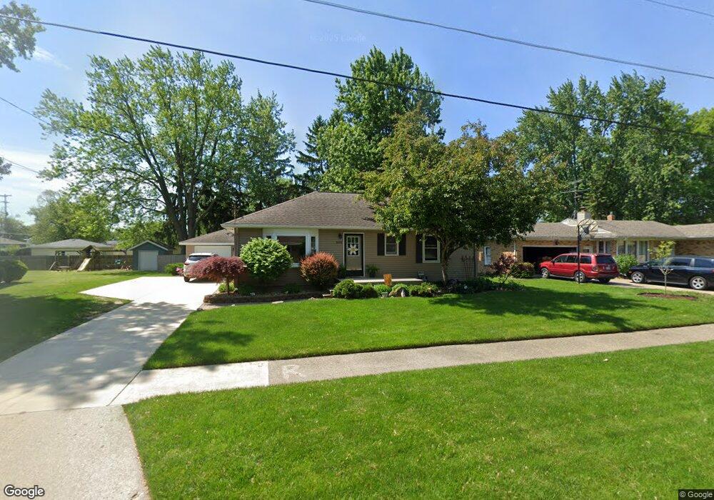
3696 Lee St Hudsonville, MI 49426
Estimated Value: $305,000 - $375,000
4
Beds
2
Baths
1,120
Sq Ft
$299/Sq Ft
Est. Value
About This Home
This home is located at 3696 Lee St, Hudsonville, MI 49426 and is currently estimated at $334,683, approximately $298 per square foot. 3696 Lee St is a home located in Ottawa County with nearby schools including Park Elementary School, Hudsonville Freshman Campus, and Hudsonville High School.
Ownership History
Date
Name
Owned For
Owner Type
Purchase Details
Closed on
May 21, 2010
Sold by
Riemersma James S
Bought by
Robinson Tonya M and Hubbard Suzanne P
Current Estimated Value
Home Financials for this Owner
Home Financials are based on the most recent Mortgage that was taken out on this home.
Original Mortgage
$130,246
Outstanding Balance
$89,200
Interest Rate
5.5%
Mortgage Type
FHA
Estimated Equity
$245,483
Purchase Details
Closed on
Feb 19, 2009
Sold by
Hearth Timothy E and Hearth Kristen L
Bought by
Mortgage Electronic Registration Systems and Accredited Home Lenders Inc
Purchase Details
Closed on
May 10, 2004
Sold by
Hearth Timothy E and Hearth Kristen L
Bought by
Hearth Timothy E and Hearth Kristen L
Home Financials for this Owner
Home Financials are based on the most recent Mortgage that was taken out on this home.
Original Mortgage
$133,000
Interest Rate
6.99%
Mortgage Type
New Conventional
Create a Home Valuation Report for This Property
The Home Valuation Report is an in-depth analysis detailing your home's value as well as a comparison with similar homes in the area
Home Values in the Area
Average Home Value in this Area
Purchase History
| Date | Buyer | Sale Price | Title Company |
|---|---|---|---|
| Robinson Tonya M | $132,000 | None Available | |
| Mortgage Electronic Registration Systems | $60,292 | None Available | |
| Hearth Timothy E | -- | Cornerstone Title Agency |
Source: Public Records
Mortgage History
| Date | Status | Borrower | Loan Amount |
|---|---|---|---|
| Open | Robinson Tonya M | $130,246 | |
| Previous Owner | Hearth Timothy E | $133,000 |
Source: Public Records
Tax History Compared to Growth
Tax History
| Year | Tax Paid | Tax Assessment Tax Assessment Total Assessment is a certain percentage of the fair market value that is determined by local assessors to be the total taxable value of land and additions on the property. | Land | Improvement |
|---|---|---|---|---|
| 2025 | $2,669 | $146,200 | $0 | $0 |
| 2024 | $2,561 | $138,100 | $0 | $0 |
| 2023 | $2,443 | $122,700 | $0 | $0 |
| 2022 | $2,423 | $107,200 | $0 | $0 |
| 2021 | $2,327 | $99,600 | $0 | $0 |
| 2020 | $2,301 | $89,500 | $0 | $0 |
| 2019 | $2,262 | $84,800 | $0 | $0 |
| 2018 | $2,015 | $75,700 | $0 | $0 |
| 2017 | $2,015 | $71,500 | $0 | $0 |
| 2016 | -- | $62,800 | $0 | $0 |
| 2015 | -- | $62,400 | $0 | $0 |
| 2014 | -- | $59,700 | $0 | $0 |
Source: Public Records
Map
Nearby Homes
- 3824 Grant St
- 5374 36th Ave Unit 37
- 5570 Marlin Ave
- 3979 Grant St
- 3505 Curtis St
- 5640 Lawndale Ave
- 5744 36th Ave
- 3540 Golfside Dr
- 3439 Hidden Cove Ln
- 4853 Meadowview Ct Unit 25
- 5557 Pleasant Ave
- 3126 Van Buren St
- 5270 Southbrook Ct Unit 64
- 4646 Canterbury Dr
- 5290 Southbrook Ct Unit 46
- Bay Harbor Plan at Valley Point - Landmark Series
- Sequoia Plan at Valley Point - Woodland Series
- Redwood Plan at Valley Point - Woodland Series
- Oakwood Plan at Valley Point - Woodland Series
- Ashton Plan at Valley Point