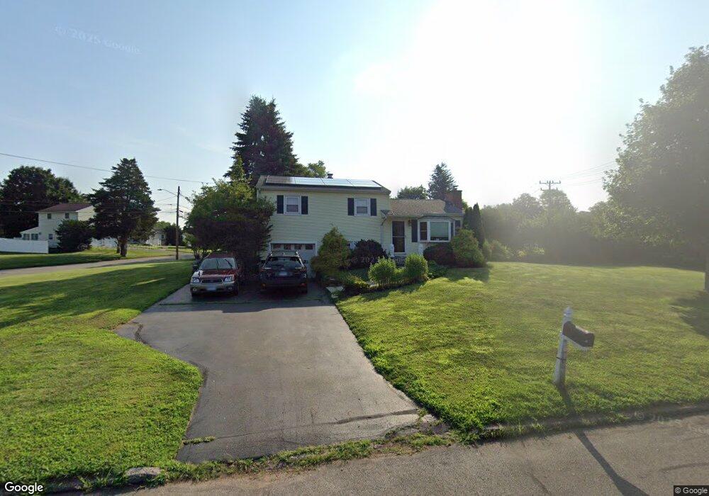
37 Byron Rd Meriden, CT 06451
Estimated Value: $360,590 - $388,000
3
Beds
1
Bath
1,300
Sq Ft
$285/Sq Ft
Est. Value
About This Home
This home is located at 37 Byron Rd, Meriden, CT 06451 and is currently estimated at $369,898, approximately $284 per square foot. 37 Byron Rd is a home located in New Haven County with nearby schools including Hanover School, Lincoln Middle School, and Orville H. Platt High School.
Ownership History
Date
Name
Owned For
Owner Type
Purchase Details
Closed on
Jul 1, 2016
Sold by
Osullivan Robert E and Osullivan Mary H
Bought by
Rossi Brian A
Current Estimated Value
Home Financials for this Owner
Home Financials are based on the most recent Mortgage that was taken out on this home.
Original Mortgage
$169,866
Outstanding Balance
$134,885
Interest Rate
3.5%
Mortgage Type
FHA
Estimated Equity
$235,013
Purchase Details
Closed on
Aug 23, 1971
Bought by
Osullivan Robert E and Osullivan Mary H
Create a Home Valuation Report for This Property
The Home Valuation Report is an in-depth analysis detailing your home's value as well as a comparison with similar homes in the area
Home Values in the Area
Average Home Value in this Area
Purchase History
| Date | Buyer | Sale Price | Title Company |
|---|---|---|---|
| Rossi Brian A | $173,000 | -- | |
| Osullivan Robert E | -- | -- |
Source: Public Records
Mortgage History
| Date | Status | Borrower | Loan Amount |
|---|---|---|---|
| Open | Osullivan Robert E | $169,866 | |
| Previous Owner | Osullivan Robert E | $94,000 | |
| Previous Owner | Osullivan Robert E | $96,575 | |
| Previous Owner | Osullivan Robert E | $30,300 |
Source: Public Records
Tax History
| Year | Tax Paid | Tax Assessment Tax Assessment Total Assessment is a certain percentage of the fair market value that is determined by local assessors to be the total taxable value of land and additions on the property. | Land | Improvement |
|---|---|---|---|---|
| 2025 | $6,133 | $152,950 | $68,390 | $84,560 |
| 2024 | $5,554 | $152,950 | $68,390 | $84,560 |
| 2023 | $5,321 | $152,950 | $68,390 | $84,560 |
| 2022 | $5,046 | $152,950 | $68,390 | $84,560 |
| 2021 | $4,814 | $117,810 | $54,040 | $63,770 |
| 2020 | $4,814 | $117,810 | $54,040 | $63,770 |
| 2019 | $4,814 | $117,810 | $54,040 | $63,770 |
| 2018 | $4,835 | $117,810 | $54,040 | $63,770 |
| 2017 | $4,703 | $117,810 | $54,040 | $63,770 |
| 2016 | $4,191 | $111,860 | $46,200 | $65,660 |
| 2015 | $4,097 | $111,860 | $46,200 | $65,660 |
| 2014 | $3,998 | $111,860 | $46,200 | $65,660 |
Source: Public Records
Map
Nearby Homes
- 105 Riverside Dr
- 97 Race Brook Rd
- 133 Stevenson Rd
- 274 Riverside Dr
- 63 Spice Hill Dr
- 100 Spice Hill Dr
- 661 Allen Ave
- 25 Andrews St
- 68 Lynn Dr
- 23 N Pond Rd
- 194 Debbie Dr
- 174 Westfort Dr
- 115 Cynrose Place
- 201 New Cheshire Rd
- 11 Kazersky Dr
- 199 Glen Hills Rd
- 295 & 305 (Lot 103 & Oregon St
- 9 Burning Tree Place
- 155 Eaton Ave
- 321 Greens Loop Unit 321
Your Personal Tour Guide
Ask me questions while you tour the home.