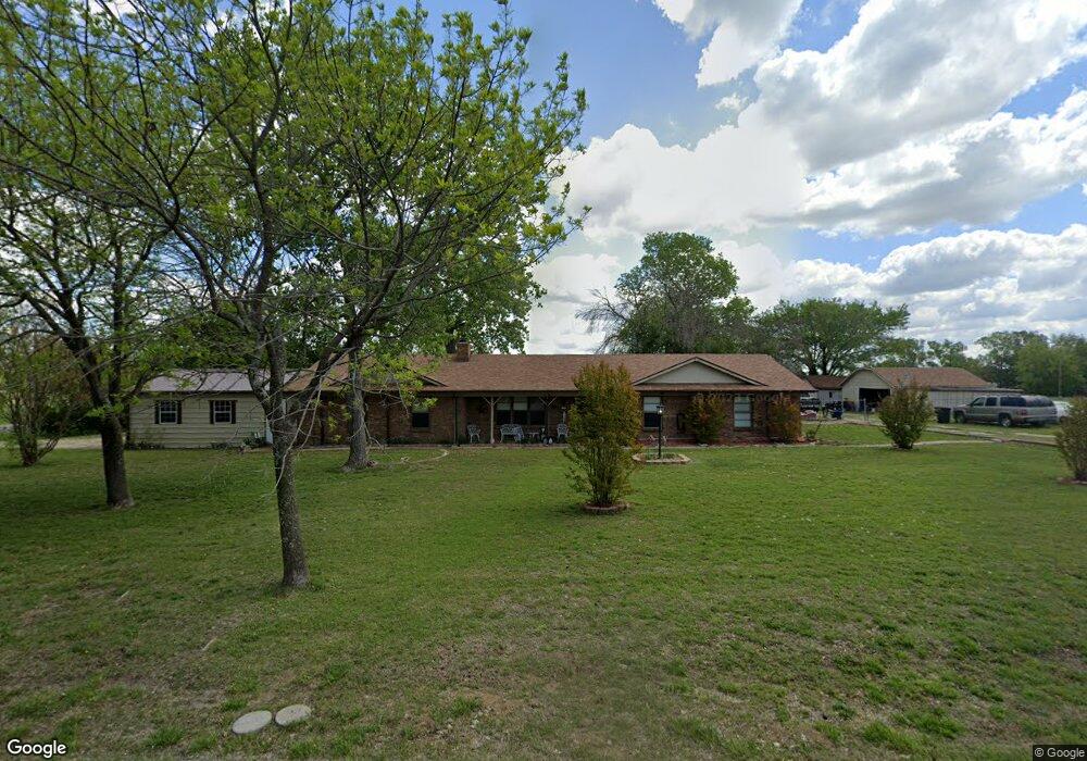
37 Choctaw Est Cir Sherman, TX 75092
Estimated Value: $405,065 - $495,000
3
Beds
2
Baths
2,179
Sq Ft
$206/Sq Ft
Est. Value
About This Home
This home is located at 37 Choctaw Est Cir, Sherman, TX 75092 and is currently estimated at $448,266, approximately $205 per square foot. 37 Choctaw Est Cir is a home located in Grayson County with nearby schools including S&S Consolidated Elementary School, S&S Consolidated Middle School, and S. & S. Cons H.S..
Ownership History
Date
Name
Owned For
Owner Type
Purchase Details
Closed on
Sep 23, 2022
Sold by
Davis Henry C and Davis Dee F
Bought by
Henry And Dee Davis Family Trust
Current Estimated Value
Purchase Details
Closed on
Dec 23, 2015
Sold by
Roth Vernon and Roth Nathan Wade
Bought by
Davis Henry C and Davis Dee F
Purchase Details
Closed on
Jun 20, 2012
Sold by
Vanneste Joe and Vanneste Hector Joseph
Bought by
Roth Vernon and Roth Nathan Wade
Create a Home Valuation Report for This Property
The Home Valuation Report is an in-depth analysis detailing your home's value as well as a comparison with similar homes in the area
Home Values in the Area
Average Home Value in this Area
Purchase History
| Date | Buyer | Sale Price | Title Company |
|---|---|---|---|
| Henry And Dee Davis Family Trust | -- | Simplifile | |
| Davis Henry C | -- | Grayson County Title | |
| Roth Vernon | -- | None Available |
Source: Public Records
Tax History Compared to Growth
Tax History
| Year | Tax Paid | Tax Assessment Tax Assessment Total Assessment is a certain percentage of the fair market value that is determined by local assessors to be the total taxable value of land and additions on the property. | Land | Improvement |
|---|---|---|---|---|
| 2025 | $616 | $290,752 | -- | -- |
| 2024 | $3,946 | $264,320 | $0 | $0 |
| 2023 | $615 | $240,291 | $0 | $0 |
| 2022 | $3,674 | $218,446 | $0 | $0 |
| 2021 | $3,777 | $211,134 | $32,000 | $179,134 |
| 2020 | $3,541 | $227,744 | $32,000 | $195,744 |
| 2019 | $3,490 | $249,800 | $32,000 | $217,800 |
| 2018 | $2,906 | $184,903 | $32,000 | $152,903 |
| 2017 | $2,660 | $168,565 | $32,000 | $136,565 |
| 2016 | $2,418 | $123,307 | $27,000 | $96,307 |
| 2015 | $2,489 | $125,769 | $21,000 | $104,769 |
| 2014 | $1,638 | $128,677 | $21,000 | $107,677 |
Source: Public Records
Map
Nearby Homes
- 6514 Joyce Ln
- 1171 Rockport Rd
- 586 Pleasant Home Rd
- 2615 Rolling Hills Dr
- 00 Primrose Ln
- 1401 Cimmaron Trail
- 3356 Old Dorchester Rd
- 1404 Tejas Dr
- 1426 S Raven Dr
- 4501 Hawk Ln
- 1407 Swan Ridge Dr
- 4507 Falcon Dr
- 6935 S Farm To Market Road 1417
- 1415 Mallard Dr
- 1412 Ascot Ave
- 2134 Peggeys Cove
- 3508 Ballam St
- 10.96 Acres Wible Rd
- 750 Wible Rd
- 4515 Hummingbird Dr
- 26 Choctaw Estate Cir
- 28 Choctaw Estate Cir
- 18 Choctaw Est Cir
- 82 Choctaw Est Cir
- 745 Choctaw Est Cir
- 112 Choctaw Est Cir
- 6820 Ob Groner Rd
- 6820 Ob Groner Rd
- 663 Choctaw Est Cir
- 157 Choctaw Est Cir
- 736 Choctaw Est Cir
- 108 Rockport Rd
- 696 Choctaw Est Cir
- 645 Choctaw Estate Cir
- 134 Rockport Rd
- 0000 Rockport Rd
- 625 Rockport Rd
- 658 Choctaw Est Cir
- 189 Choctaw Est Cir
- 200 Choctaw Est Cir