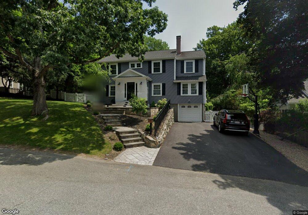
37 Circuit Rd Westwood, MA 02090
Estimated Value: $908,000 - $1,095,000
2
Beds
1
Bath
1,128
Sq Ft
$894/Sq Ft
Est. Value
About This Home
This home is located at 37 Circuit Rd, Westwood, MA 02090 and is currently estimated at $1,008,077, approximately $893 per square foot. 37 Circuit Rd is a home located in Norfolk County with nearby schools including Westwood High School, St Catherine Of Siena School, and Xaverian Brothers High School.
Ownership History
Date
Name
Owned For
Owner Type
Purchase Details
Closed on
Nov 15, 2011
Sold by
Caputo Adam S and Lyman Christine E
Bought by
Smith Sean M and Smith Toni M
Current Estimated Value
Home Financials for this Owner
Home Financials are based on the most recent Mortgage that was taken out on this home.
Original Mortgage
$391,809
Outstanding Balance
$263,668
Interest Rate
3.75%
Mortgage Type
FHA
Estimated Equity
$744,409
Purchase Details
Closed on
Apr 30, 2007
Sold by
Sexton Joseph A and Sexton Mary L
Bought by
Caputo Adam S and Lyman Christine E
Home Financials for this Owner
Home Financials are based on the most recent Mortgage that was taken out on this home.
Original Mortgage
$292,000
Interest Rate
6.18%
Mortgage Type
Purchase Money Mortgage
Create a Home Valuation Report for This Property
The Home Valuation Report is an in-depth analysis detailing your home's value as well as a comparison with similar homes in the area
Home Values in the Area
Average Home Value in this Area
Purchase History
| Date | Buyer | Sale Price | Title Company |
|---|---|---|---|
| Smith Sean M | $402,000 | -- | |
| Caputo Adam S | $365,000 | -- |
Source: Public Records
Mortgage History
| Date | Status | Borrower | Loan Amount |
|---|---|---|---|
| Open | Smith Sean M | $391,809 | |
| Previous Owner | Caputo Adam S | $292,000 | |
| Previous Owner | Caputo Adam S | $54,750 |
Source: Public Records
Tax History Compared to Growth
Tax History
| Year | Tax Paid | Tax Assessment Tax Assessment Total Assessment is a certain percentage of the fair market value that is determined by local assessors to be the total taxable value of land and additions on the property. | Land | Improvement |
|---|---|---|---|---|
| 2025 | $11,777 | $920,100 | $491,700 | $428,400 |
| 2024 | $11,534 | $900,400 | $468,400 | $432,000 |
| 2023 | $10,239 | $716,000 | $390,200 | $325,800 |
| 2022 | $9,481 | $639,300 | $330,000 | $309,300 |
| 2021 | $9,380 | $634,650 | $314,350 | $320,300 |
| 2020 | $9,088 | $626,350 | $314,350 | $312,000 |
| 2019 | $8,690 | $593,200 | $299,350 | $293,850 |
| 2018 | $8,588 | $569,150 | $299,350 | $269,800 |
| 2017 | $8,101 | $556,000 | $299,350 | $256,650 |
| 2016 | $7,718 | $526,500 | $299,350 | $227,150 |
| 2015 | $7,510 | $492,750 | $299,350 | $193,400 |
Source: Public Records
Map
Nearby Homes