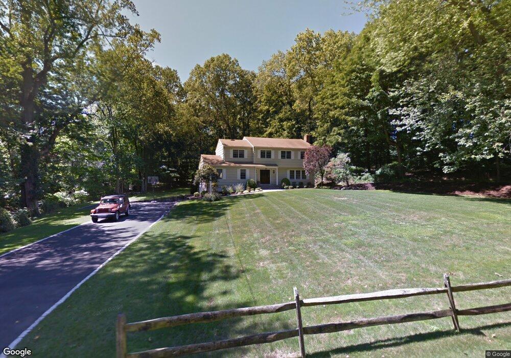
37 Colony Rd Westport, CT 06880
Staples NeighborhoodEstimated Value: $1,865,000 - $2,285,000
5
Beds
3
Baths
3,316
Sq Ft
$604/Sq Ft
Est. Value
About This Home
This home is located at 37 Colony Rd, Westport, CT 06880 and is currently estimated at $2,002,941, approximately $604 per square foot. 37 Colony Rd is a home located in Fairfield County with nearby schools including Long Lots School, Bedford Middle School, and Staples High School.
Ownership History
Date
Name
Owned For
Owner Type
Purchase Details
Closed on
Jun 25, 2018
Sold by
Lustig Adam and Lustig Hilary
Bought by
Adam Lustig Ret
Current Estimated Value
Purchase Details
Closed on
Dec 14, 2017
Sold by
Hilary Lustig Ret
Bought by
Lustig Adam and Lustig Hilary
Purchase Details
Closed on
Aug 10, 2013
Sold by
Lustig Adam and Lustig Hilary
Bought by
Adam Lustig Ret and Lustig
Purchase Details
Closed on
Mar 28, 1991
Sold by
Grant Anne
Bought by
Goldstein Steven and Goldstein Jennifer
Create a Home Valuation Report for This Property
The Home Valuation Report is an in-depth analysis detailing your home's value as well as a comparison with similar homes in the area
Home Values in the Area
Average Home Value in this Area
Purchase History
| Date | Buyer | Sale Price | Title Company |
|---|---|---|---|
| Adam Lustig Ret | -- | -- | |
| Adam Lustig Ret | -- | -- | |
| Lustig Adam | -- | -- | |
| Lustig Adam | -- | -- | |
| Lustig Adam | -- | -- | |
| Lustig Adam | -- | -- | |
| Adam Lustig Ret | -- | -- | |
| Adam Lustig Ret | -- | -- | |
| Goldstein Steven | $480,000 | -- |
Source: Public Records
Mortgage History
| Date | Status | Borrower | Loan Amount |
|---|---|---|---|
| Previous Owner | Goldstein Steven | $750,000 | |
| Previous Owner | Goldstein Steven | $350,000 | |
| Previous Owner | Goldstein Steven | $610,000 |
Source: Public Records
Tax History Compared to Growth
Tax History
| Year | Tax Paid | Tax Assessment Tax Assessment Total Assessment is a certain percentage of the fair market value that is determined by local assessors to be the total taxable value of land and additions on the property. | Land | Improvement |
|---|---|---|---|---|
| 2025 | $15,669 | $830,800 | $428,800 | $402,000 |
| 2024 | $15,469 | $830,800 | $428,800 | $402,000 |
| 2023 | $15,245 | $830,800 | $428,800 | $402,000 |
| 2022 | $15,013 | $830,800 | $428,800 | $402,000 |
| 2021 | $7,807 | $830,800 | $428,800 | $402,000 |
| 2020 | $14,910 | $915,500 | $439,100 | $476,400 |
| 2019 | $8,531 | $915,500 | $439,100 | $476,400 |
| 2018 | $7,470 | $915,500 | $439,100 | $476,400 |
| 2017 | $15,435 | $915,500 | $439,100 | $476,400 |
| 2016 | $15,435 | $915,500 | $439,100 | $476,400 |
| 2015 | $13,846 | $765,400 | $363,500 | $401,900 |
| 2014 | $13,731 | $765,400 | $363,500 | $401,900 |
Source: Public Records
Map
Nearby Homes
- 9 Burr Farms Rd
- 13 Terhune Dr
- 116 Roseville Rd
- 16 Burr School Rd
- 14 Burr School Rd
- 4 Burr Farms Rd
- 5 Willow Walk
- 2 Webb Rd
- 32 Webb Rd
- 19 Joann Cir
- 7 Morningside Ln
- 785 Post Rd E Unit 301
- 785 Post Rd E Unit 303
- 785 Post Rd E Unit 302
- 785 Post Rd E Unit 201
- 785 Post Rd E Unit 304
- 785 Post Rd E Unit 102
- 785 Post Rd E Unit 104
- 19A Darbrook Rd
- 28 Crescent Park Rd