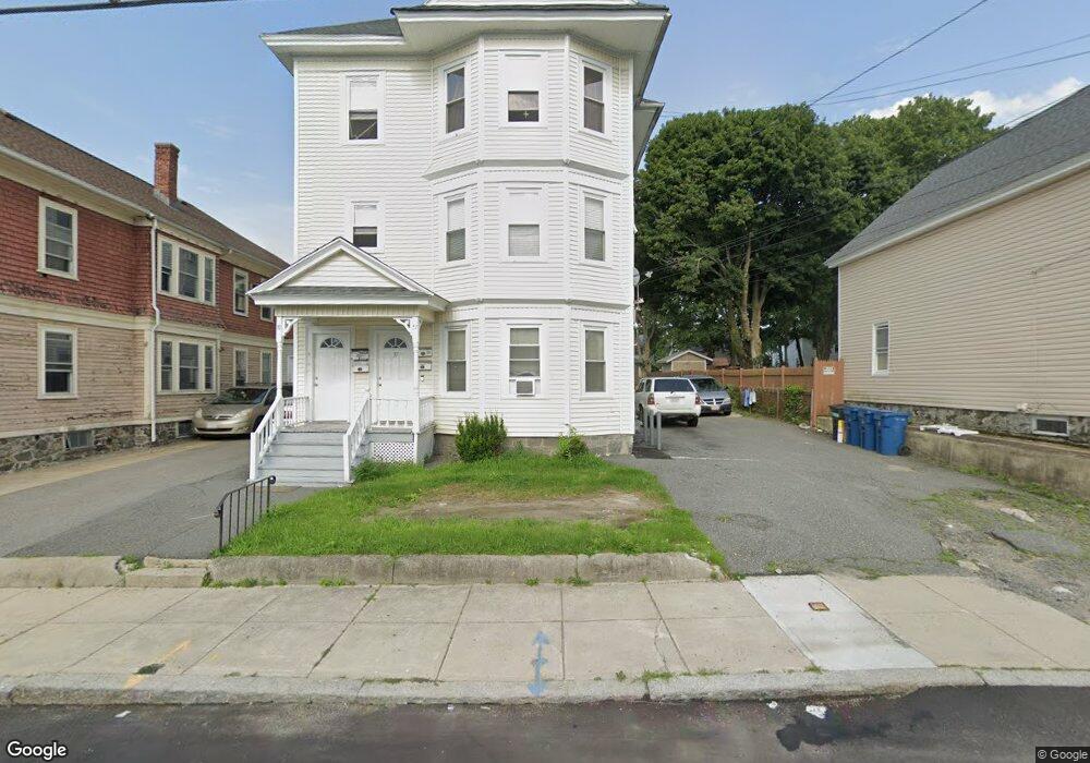
37 Kendall St Unit 39 Lawrence, MA 01841
Prospect Hill-Back Bay NeighborhoodEstimated Value: $868,000 - $916,000
6
Beds
3
Baths
3,955
Sq Ft
$226/Sq Ft
Est. Value
About This Home
This home is located at 37 Kendall St Unit 39, Lawrence, MA 01841 and is currently estimated at $893,333, approximately $225 per square foot. 37 Kendall St Unit 39 is a home located in Essex County with nearby schools including School For Exceptional Studies, Community Day Charter Public School - Gateway, and Esperanza Academy School of Hope.
Ownership History
Date
Name
Owned For
Owner Type
Purchase Details
Closed on
Mar 12, 2013
Sold by
Cruz Johanna A
Bought by
Espinola Gene
Current Estimated Value
Purchase Details
Closed on
Oct 14, 1999
Sold by
Kochanczyk A William
Bought by
Cruz Johanna A
Home Financials for this Owner
Home Financials are based on the most recent Mortgage that was taken out on this home.
Original Mortgage
$137,930
Interest Rate
7.8%
Mortgage Type
Purchase Money Mortgage
Create a Home Valuation Report for This Property
The Home Valuation Report is an in-depth analysis detailing your home's value as well as a comparison with similar homes in the area
Home Values in the Area
Average Home Value in this Area
Purchase History
| Date | Buyer | Sale Price | Title Company |
|---|---|---|---|
| Espinola Gene | $141,000 | -- | |
| Cruz Johanna A | $138,000 | -- |
Source: Public Records
Mortgage History
| Date | Status | Borrower | Loan Amount |
|---|---|---|---|
| Previous Owner | Cruz Johanna A | $137,930 |
Source: Public Records
Tax History
| Year | Tax Paid | Tax Assessment Tax Assessment Total Assessment is a certain percentage of the fair market value that is determined by local assessors to be the total taxable value of land and additions on the property. | Land | Improvement |
|---|---|---|---|---|
| 2025 | $7,050 | $801,100 | $138,700 | $662,400 |
| 2024 | $6,705 | $724,900 | $120,100 | $604,800 |
| 2023 | $6,740 | $663,400 | $120,100 | $543,300 |
| 2022 | $5,955 | $520,500 | $107,100 | $413,400 |
| 2021 | $5,618 | $457,900 | $107,100 | $350,800 |
| 2020 | $5,452 | $438,600 | $105,500 | $333,100 |
| 2019 | $5,434 | $397,200 | $84,300 | $312,900 |
| 2018 | $5,211 | $363,900 | $80,400 | $283,500 |
| 2017 | $4,697 | $306,200 | $74,100 | $232,100 |
| 2016 | $4,332 | $279,300 | $66,300 | $213,000 |
| 2015 | $3,960 | $261,900 | $53,100 | $208,800 |
Source: Public Records
Map
Nearby Homes
- 39 Swan Ave
- 14 Court St
- 106 Leroy Ave
- 109 Ferry St
- 5 Kendrick St
- 2 Leslie St
- 12 Annette St
- 264 E Haverhill St Unit 2
- 18 Erhardt Terrace
- 192 Union St
- 32 Josephine Ave
- 7 Erhardt Terrace
- 25-27 Bicknell Ave
- 80-82 Haverhill St
- 89 Newbury St Unit 89B
- 91 Summer St Unit 2
- 129-131 Lexington St
- 65 Arthur St
- 131A Lawrence St Unit 40
- 68 Ashford St
- 41 Kendall St Unit 43
- 41-43 Kendall St
- 35 Kendall St
- 190 Ferry St
- 49 Kendall St
- 180 Ferry St
- 33 Kendall St
- 31 Kendall St
- 31 Kendall St Unit 2
- 31 Kendall St Unit 1
- 38 Kendall St
- 36 Kendall St
- 178 Ferry St
- 34 Kendall St
- 40 Kendall St
- 176 Ferry St
- 50 Oakwood Ave
- 42 Kendall St Unit 44
- 30 Kendall St
- 27 Kendall St
Your Personal Tour Guide
Ask me questions while you tour the home.