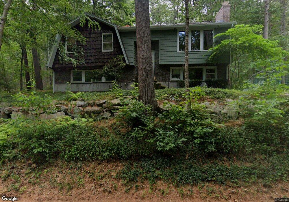
37 Mill St Foxboro, MA 02035
Estimated Value: $578,780 - $654,000
3
Beds
3
Baths
1,132
Sq Ft
$546/Sq Ft
Est. Value
About This Home
This home is located at 37 Mill St, Foxboro, MA 02035 and is currently estimated at $617,695, approximately $545 per square foot. 37 Mill St is a home located in Norfolk County with nearby schools including Foxborough High School, Foxborough Regional Charter School, and Hands-On-Montessori School.
Ownership History
Date
Name
Owned For
Owner Type
Purchase Details
Closed on
Sep 9, 2025
Sold by
Knight Raymond A and Knight Judith S
Bought by
Knight Irt and Knight
Current Estimated Value
Purchase Details
Closed on
Feb 13, 1975
Bought by
Knight Raymond A and Knight Judith S
Create a Home Valuation Report for This Property
The Home Valuation Report is an in-depth analysis detailing your home's value as well as a comparison with similar homes in the area
Home Values in the Area
Average Home Value in this Area
Purchase History
| Date | Buyer | Sale Price | Title Company |
|---|---|---|---|
| Knight Irt | -- | -- | |
| Knight Raymond A | $40,000 | -- |
Source: Public Records
Mortgage History
| Date | Status | Borrower | Loan Amount |
|---|---|---|---|
| Previous Owner | Knight Raymond A | $27,000 | |
| Previous Owner | Knight Raymond A | $16,000 | |
| Previous Owner | Knight Raymond A | $40,000 | |
| Previous Owner | Knight Raymond A | $73,000 |
Source: Public Records
Tax History
| Year | Tax Paid | Tax Assessment Tax Assessment Total Assessment is a certain percentage of the fair market value that is determined by local assessors to be the total taxable value of land and additions on the property. | Land | Improvement |
|---|---|---|---|---|
| 2025 | $6,455 | $488,300 | $180,000 | $308,300 |
| 2024 | $6,063 | $448,800 | $180,000 | $268,800 |
| 2023 | $5,850 | $411,700 | $171,500 | $240,200 |
| 2022 | $5,644 | $388,700 | $164,000 | $224,700 |
| 2021 | $5,236 | $355,200 | $149,100 | $206,100 |
| 2020 | $4,859 | $333,500 | $149,100 | $184,400 |
| 2019 | $4,753 | $323,300 | $142,000 | $181,300 |
| 2018 | $4,620 | $317,100 | $142,000 | $175,100 |
| 2017 | $4,514 | $300,100 | $132,700 | $167,400 |
| 2016 | $4,199 | $283,300 | $127,700 | $155,600 |
| 2015 | $4,041 | $266,000 | $107,800 | $158,200 |
| 2014 | $4,155 | $277,200 | $105,700 | $171,500 |
Source: Public Records
Map
Nearby Homes
- 34 Mill St
- 32 Mill St
- 28 Mill St
- 24 Mill St
- 3 Bristol Ln
- 1 Bristol Ln
- 1 Bristol Ln
- 10 Mill St
- Lot 3 Bristol Ln
- Lot 2 Bristol Ln
- 9 Lot 9 Mill Street Preserve
- lot 9 Mill Street Preserve
- 2 Bristol Ln
- 5 Bristol Ln
- lot 8 Mill Street Preserve
- 9 Mill St Unit 9
- 82 Prospect St
- 7 Bristol Ln
- 63 Mill St
- 78 Prospect St
Your Personal Tour Guide
Ask me questions while you tour the home.