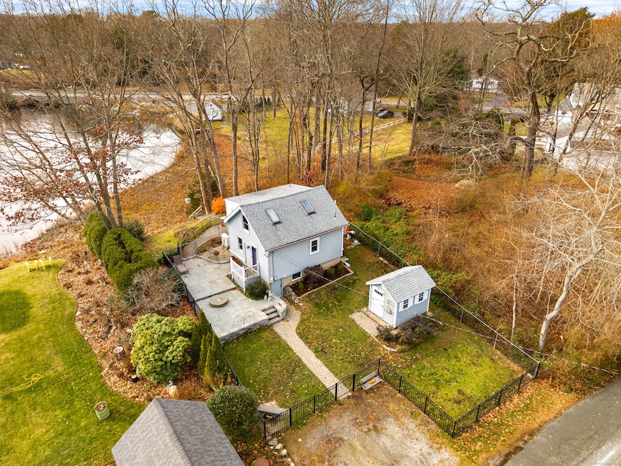
37 Nolin Rd Westbrook, CT 06498
Estimated payment $2,194/month
Highlights
- Waterfront
- Open Floorplan
- Patio
- Westbrook Middle School Rated A-
- Cape Cod Architecture
- Shed
About This Home
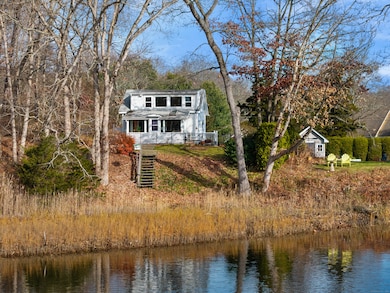
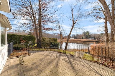
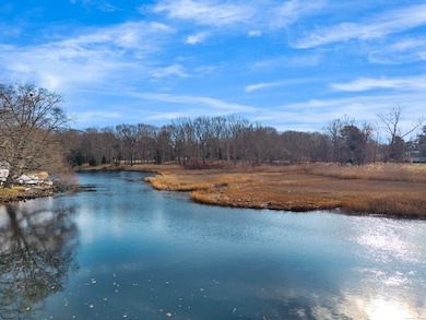
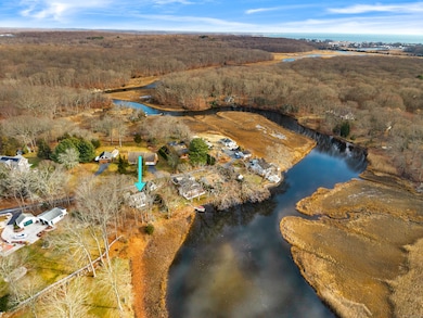
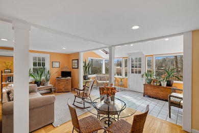
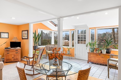
**OFFER DEADLINE: Monday 12/8 by 12:00 Noon** Charming, waterfront, treehouse-like, retreat on the Menunketesuck River. Discover the perfect river front getaway in this bright and inviting one-bedroom home in the popular beach town of Westbrook. Steps from your front door, paddle through the tranquil waters of the river flowing through the McKinney National Wildlife Refuge and Goodwin Marsh Nature Conservancy-a breathtaking 5-mile round-trip by canoe or kayak (sourced from bostonkayaker) that leads all the way to the Long Island Sound. Designed with an open, airy floor plan, this efficient home features hardwood floors, a recently updated kitchen, and a cozy sunporch that captures stunning year-round views. Expansive windows fill every room with natural light and frame the ever-changing beauty of the surrounding landscape. Located on a quiet dead-end street, this property offers exceptional privacy, abundant wildlife, and water access for canoes, kayaks, and small watercraft. Whether you're seeking a serene weekend escape, a nature lover's haven, or a low-maintenance full-time residence, this charming waterfront home delivers peace, simplicity, and unmatched natural beauty.
Listing Agent
William Raveis Real Estate Brokerage Phone: (860) 304-6896 License #RES.0809692 Listed on: 12/05/2025

Home Details
Home Type
- Single Family
Est. Annual Taxes
- $3,173
Year Built
- Built in 1940
Lot Details
- 7,405 Sq Ft Lot
- Waterfront
- Property is zoned RR
Home Design
- Cape Cod Architecture
- Bungalow
- Concrete Foundation
- Frame Construction
- Asphalt Shingled Roof
- Vinyl Siding
- Radon Mitigation System
Interior Spaces
- 785 Sq Ft Home
- Open Floorplan
- Water Views
- Smart Locks
Kitchen
- Electric Range
- Microwave
- Dishwasher
Bedrooms and Bathrooms
- 1 Bedroom
- 1 Full Bathroom
Laundry
- Electric Dryer
- Washer
Unfinished Basement
- Walk-Out Basement
- Basement Fills Entire Space Under The House
- Interior Basement Entry
- Laundry in Basement
Outdoor Features
- Patio
- Shed
- Rain Gutters
Utilities
- Split Air Conditioning
- Baseboard Heating
- Electric Water Heater
- Cable TV Available
Listing and Financial Details
- Assessor Parcel Number 1042058
Map
Home Values in the Area
Average Home Value in this Area
Tax History
| Year | Tax Paid | Tax Assessment Tax Assessment Total Assessment is a certain percentage of the fair market value that is determined by local assessors to be the total taxable value of land and additions on the property. | Land | Improvement |
|---|---|---|---|---|
| 2025 | $3,173 | $141,010 | $76,340 | $64,670 |
| 2024 | $3,060 | $141,010 | $76,340 | $64,670 |
| 2023 | $3,006 | $141,010 | $76,340 | $64,670 |
| 2022 | $2,927 | $141,010 | $76,340 | $64,670 |
| 2021 | $2,716 | $108,630 | $47,710 | $60,920 |
| 2020 | $2,716 | $108,630 | $47,710 | $60,920 |
| 2019 | $2,680 | $108,630 | $47,710 | $60,920 |
| 2018 | $2,647 | $108,630 | $47,710 | $60,920 |
| 2017 | $2,647 | $108,630 | $47,710 | $60,920 |
| 2016 | $2,456 | $106,120 | $42,410 | $63,710 |
| 2015 | $2,389 | $106,120 | $42,410 | $63,710 |
| 2014 | $2,312 | $106,120 | $42,410 | $63,710 |
Property History
| Date | Event | Price | List to Sale | Price per Sq Ft |
|---|---|---|---|---|
| 12/09/2025 12/09/25 | Pending | -- | -- | -- |
| 12/05/2025 12/05/25 | For Sale | $375,000 | -- | $478 / Sq Ft |
Purchase History
| Date | Type | Sale Price | Title Company |
|---|---|---|---|
| Warranty Deed | $105,000 | -- | |
| Deed | $132,700 | -- |
Mortgage History
| Date | Status | Loan Amount | Loan Type |
|---|---|---|---|
| Closed | $23,000 | No Value Available | |
| Open | $78,000 | Purchase Money Mortgage | |
| Previous Owner | $95,000 | Purchase Money Mortgage |
Source: SmartMLS
MLS Number: 24143137
APN: WBRO-000173-000000-000011
Disclaimer: Certain information contained herein is derived from information provided by parties other than Homes.com. All information provided is deemed reliable, but is not guaranteed to be accurate and should be independently verified.
![]() IDX information is provided exclusively for personal, non-commercial use, and may not be used for any purpose other than to identify prospective properties consumers may be interested in purchasing. Information is deemed reliable but not guaranteed.
IDX information is provided exclusively for personal, non-commercial use, and may not be used for any purpose other than to identify prospective properties consumers may be interested in purchasing. Information is deemed reliable but not guaranteed.
- 407 Grove Beach Rd N
- 5 Meadow Point Rd
- 86 Grove Beach Rd N
- 5 Robin Ln
- 40 Beach Rd
- 6 Evergreen Dr
- 19 Evergreen Dr
- 81 Founders Village Unit 81
- 31 Founders Village
- 39 Founders Village Unit 39
- 280 E Main St Unit E2
- 0 Causeway
- 2 Plymouth Ct Unit 2
- 176 Shore Rd
- 328 Hammock Rd N
- 0 E Main St
- 40 Hammock Rd S
- 951 Old Clinton Rd Unit 15
- 192 E Main St
- 0 Boston Post Rd Unit 24080344
Ask me questions while you tour the home.