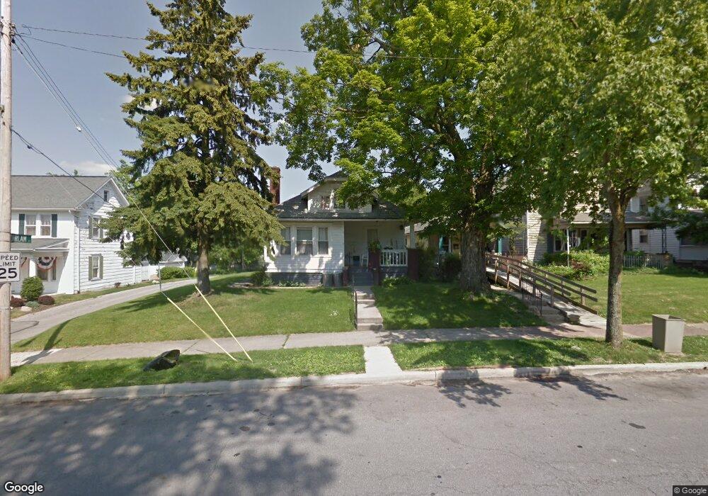
37 Sherman Ave Mansfield, OH 44906
Estimated Value: $105,000 - $136,000
3
Beds
1
Bath
1,156
Sq Ft
$105/Sq Ft
Est. Value
About This Home
This home is located at 37 Sherman Ave, Mansfield, OH 44906 and is currently estimated at $121,917, approximately $105 per square foot. 37 Sherman Ave is a home located in Richland County with nearby schools including Goal Digital Academy, St. Peter's Elementary/Montessori School, and St. Peter's Junior High / High School.
Ownership History
Date
Name
Owned For
Owner Type
Purchase Details
Closed on
Aug 22, 2017
Sold by
Paul Esterline
Bought by
Kirkwood Esther and Kirkwood Charles
Current Estimated Value
Home Financials for this Owner
Home Financials are based on the most recent Mortgage that was taken out on this home.
Original Mortgage
$12,000
Outstanding Balance
$9,994
Interest Rate
3.89%
Estimated Equity
$111,923
Purchase Details
Closed on
May 26, 1994
Sold by
Elsass Irvin C
Bought by
Esterline Wayne A
Purchase Details
Closed on
Feb 1, 1986
Create a Home Valuation Report for This Property
The Home Valuation Report is an in-depth analysis detailing your home's value as well as a comparison with similar homes in the area
Home Values in the Area
Average Home Value in this Area
Purchase History
| Date | Buyer | Sale Price | Title Company |
|---|---|---|---|
| Kirkwood Esther | $15,000 | -- | |
| Esterline Wayne A | $20,000 | -- | |
| -- | $20,900 | -- |
Source: Public Records
Mortgage History
| Date | Status | Borrower | Loan Amount |
|---|---|---|---|
| Open | Kirkwood Esther | $12,000 | |
| Closed | Kirkwood Esther | -- |
Source: Public Records
Tax History
| Year | Tax Paid | Tax Assessment Tax Assessment Total Assessment is a certain percentage of the fair market value that is determined by local assessors to be the total taxable value of land and additions on the property. | Land | Improvement |
|---|---|---|---|---|
| 2024 | $1,245 | $27,190 | $4,310 | $22,880 |
| 2023 | $1,273 | $27,190 | $4,310 | $22,880 |
| 2022 | $1,041 | $18,630 | $3,500 | $15,130 |
| 2021 | $1,048 | $18,630 | $3,500 | $15,130 |
| 2020 | $1,072 | $18,630 | $3,500 | $15,130 |
| 2019 | $1,188 | $18,630 | $3,500 | $15,130 |
| 2018 | $1,172 | $18,630 | $3,500 | $15,130 |
| 2017 | $628 | $18,630 | $3,500 | $15,130 |
| 2016 | $1,165 | $18,460 | $3,720 | $14,740 |
| 2015 | $1,165 | $18,460 | $3,720 | $14,740 |
| 2014 | $1,098 | $18,460 | $3,720 | $14,740 |
| 2012 | $1,011 | $18,460 | $3,920 | $14,540 |
Source: Public Records
Map
Nearby Homes
- 31 Bartley Ave
- 71 Dawson Ave
- 30 Douglas Ave
- 126 Dawson Ave
- 108 Stewart Ave S
- 116 Stewart Ave S
- 133 Stewart Ave S
- 458 W West Dickson Ave
- 51 Lind Ave
- 31 Parkwood Blvd
- 519 Heineman Blvd
- 10 Gray Ct
- 190 Dawson Ave
- 189 Westwood Ave
- 183 Carpenter Rd
- 455 Marion Ave
- 135 Wood St
- 212 Penn Ave
- 344 W 5th St
- 230 Rae Ave
- 495 Dirlam Ct
- 41 Sherman Ave
- 300 Lenox Ave
- 47 Sherman Ave
- 33 Sherman Ave
- 489 Dirlam Ct
- 49 Sherman Ave
- 31 Sherman Ave
- 29 Sherman Ave
- 485 Dirlam Ct
- 42 Sherman Ave
- 53 Sherman Ave
- 36 Sherman Ave
- 481 Dirlam Ct
- 32 Sherman Ave
- 52 Sherman Ave
- 52 Sherman Ave Unit 52
- 24 Sherman Ave
- 57 Sherman Ave
- 515 Summit St
Your Personal Tour Guide
Ask me questions while you tour the home.