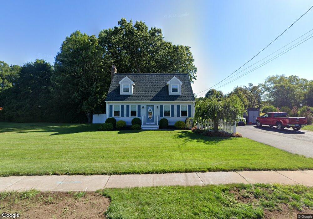
37 Simon Rd Enfield, CT 06082
Enfield AreaEstimated Value: $365,000 - $393,218
About This Home
This home is located at 37 Simon Rd, Enfield, CT 06082 and is currently estimated at $379,055, approximately $245 per square foot. 37 Simon Rd is a home located in Hartford County with nearby schools including Edgar H. Parkman School, Enfield Street Elementary School, and Enfield High School.
Ownership History
We collect this data history from publicly available records. To have your information removed, we recommend requesting removal directly through your county’s website.
Purchase Details
Purchase Details
Home Values in the Area
Average Home Value in this Area
Purchase History
We collect this data history from publicly available records. To have your information removed, we recommend requesting removal directly through your county’s website.
| Date | Buyer | Sale Price | Title Company |
|---|---|---|---|
| $140,000 | -- | ||
| $143,500 | -- |
Mortgage History
We collect this data history from publicly available records. To have your information removed, we recommend requesting removal directly through your county’s website.
| Date | Status | Borrower | Loan Amount |
|---|---|---|---|
| Open | $60,000 | ||
| Closed | $25,000 | ||
| Closed | $33,390 | ||
| Closed | $135,950 |
Tax History
We collect this data history from publicly available records. To have your information removed, we recommend requesting removal directly through your county’s website.
| Year | Tax Paid | Tax Assessment Tax Assessment Total Assessment is a certain percentage of the fair market value that is determined by local assessors to be the total taxable value of land and additions on the property. | Land | Improvement |
|---|---|---|---|---|
| 2025 | $6,585 | $188,200 | $60,100 | $128,100 |
| 2024 | $6,408 | $188,200 | $60,100 | $128,100 |
| 2023 | $6,361 | $188,200 | $60,100 | $128,100 |
| 2022 | $5,776 | $188,200 | $60,100 | $128,100 |
| 2021 | $5,571 | $148,430 | $49,620 | $98,810 |
| 2020 | $5,571 | $148,430 | $49,620 | $98,810 |
| 2019 | $5,585 | $148,430 | $49,620 | $98,810 |
| 2018 | $5,492 | $148,430 | $49,620 | $98,810 |
| 2017 | $5,185 | $148,430 | $49,620 | $98,810 |
| 2016 | $5,087 | $148,260 | $50,920 | $97,340 |
| 2015 | $4,928 | $148,260 | $50,920 | $97,340 |
| 2014 | $4,801 | $148,260 | $50,920 | $97,340 |
Map
- 18 Windmill Rd
- 60 Simon Rd
- 14 Wynwood Dr Unit 14
- 233 Post Office Rd
- 170 Weymouth Rd
- 188 Post Office Rd Unit 6
- 1 Lois Ln
- 25 Putnam Dr
- 6 Madison Rd
- 2 Sparkle St
- 52 Bass Dr
- 9 Renee Ln
- 23 Parky Dr
- 10 Pilgrim Cir
- 43 Carriage House Unit 43
- 17 Eileen Ln
- 18 Bess Rd
- 146 Post Office Rd
- 13 Tolland Dr
- 17 Pioneer Dr
Ask me questions while you tour the home.