
Seller's Agent in 2026
Jack Brown
RE/MAX
(508) 284-5098
6 in this area
153 Total Sales
Estimated Value: $1,379,000 - $1,852,000
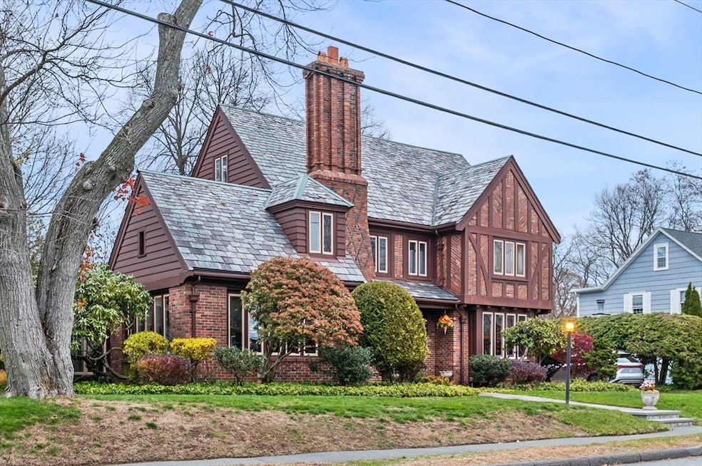
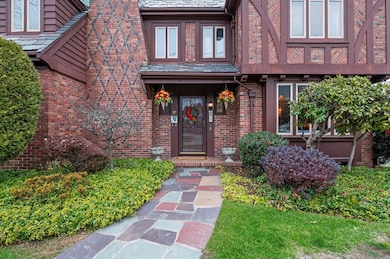
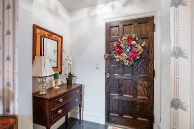
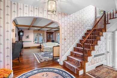
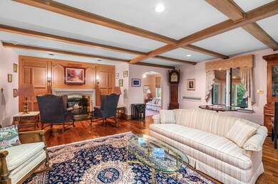
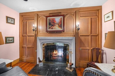
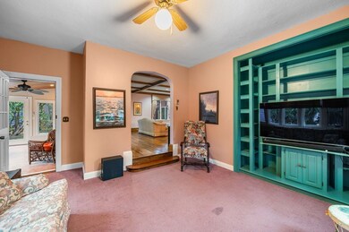
This classic Tudor offers warmth, character, and exceptional space. The living room features a large fireplace, reading alcove, and room to entertain, opening to a bright den and an updated sunroom with access to the yard. The spacious dining room has morning light, chair rail, crown molding, and stained glass side windows. The large eat-in kitchen includes ample cabinets, a bar sink, a breakfast bar, and a step-down sitting area with great yard views, two doors to the outside, a built-in desk, and access to the second floor and finished basement. The basement adds a bar, fireplace, workroom, storage, and laundry. The second floor offers six bedrooms and three baths, including two potential en suite options, plus a full walk-up attic. The private yard features a main patio, grilling patio, oversized garage, and a two-story playhouse or garden space with star-watching windows and a loft, along with rear fencing and a gate to the next street. Close to the beach, shops, restaurants, etc.
We collect this data history from publicly available records. To have your information removed, we recommend requesting removal directly through your county’s website.
We collect this data history from publicly available records. To have your information removed, we recommend requesting removal directly through your county’s website.
| Date | Buyer | Sale Price | Title Company |
|---|---|---|---|
| $1,415,000 | -- | ||
| $451,000 | -- | ||
| $451,000 | -- |
We collect this data history from publicly available records. To have your information removed, we recommend requesting removal directly through your county’s website.
| Date | Status | Borrower | Loan Amount |
|---|---|---|---|
| Previous Owner | $318,500 |
We collect this data history from publicly available records. To have your information removed, we recommend requesting removal directly through your county’s website.
| Date | Event | Price | List to Sale | Price per Sq Ft |
|---|---|---|---|---|
| 02/27/2026 02/27/26 | Sold | $1,415,000 | -2.4% | $337 / Sq Ft |
| 01/08/2026 01/08/26 | Pending | -- | -- | -- |
| 01/05/2026 01/05/26 | For Sale | $1,450,000 | +2.5% | $346 / Sq Ft |
| 12/19/2025 12/19/25 | Off Market | $1,415,000 | -- | -- |
| 12/02/2025 12/02/25 | For Sale | $1,450,000 | -- | $346 / Sq Ft |
We collect this data history from publicly available records. To have your information removed, we recommend requesting removal directly through your county’s website.
| Year | Tax Paid | Tax Assessment Tax Assessment Total Assessment is a certain percentage of the fair market value that is determined by local assessors to be the total taxable value of land and additions on the property. | Land | Improvement |
|---|---|---|---|---|
| 2025 | $16,628 | $1,449,700 | $432,000 | $1,017,700 |
| 2024 | $16,374 | $1,425,100 | $432,000 | $993,100 |
| 2023 | $15,053 | $1,282,200 | $389,800 | $892,400 |
| 2022 | $14,189 | $1,105,900 | $337,200 | $768,700 |
| 2021 | $14,625 | $1,059,800 | $305,600 | $754,200 |
| 2020 | $14,536 | $1,016,500 | $273,900 | $742,600 |
| 2019 | $15,168 | $997,900 | $252,900 | $745,000 |
| 2018 | $14,851 | $928,200 | $231,800 | $696,400 |
| 2017 | $14,836 | $850,200 | $202,300 | $647,900 |
| 2016 | $14,734 | $850,200 | $202,300 | $647,900 |
| 2015 | $14,581 | $850,200 | $202,300 | $647,900 |
| 2014 | $13,511 | $722,500 | $189,700 | $532,800 |
Seller's Agent in 2026
Jack Brown
RE/MAX
(508) 284-5098
6 in this area
153 Total Sales
Seller Co-Listing Agent in 2026
Heather Murray
RE/MAX
(617) 967-8231
1 in this area
8 Total Sales
Buyer's Agent in 2026
Lisa Wheeler
J. Barrett & Company
1 in this area
12 Total Sales
Source: MLS Property Information Network (MLS PIN)
MLS Number: 73459041
APN: SWAM-000027-000107
Disclaimer: Certain information contained herein is derived from information provided by parties other than Homes.com. All information provided is deemed reliable, but is not guaranteed to be accurate and should be independently verified.
![]() The property listing data and information, or the Images, set forth herein were provided to MLS Property Information Network, Inc. from third party sources, including sellers, lessors and public records, and were compiled by MLS Property Information Network, Inc. The property listing data and information, and the Images, are for the personal, non-commercial use of consumers having a good faith interest in purchasing or leasing listed properties of the type displayed to them and may not be used for any purpose other than to identify prospective properties which such consumers may have a good faith interest in purchasing or leasing. MLS Property Information Network, Inc. and its subscribers disclaim any and all representations and warranties as to the accuracy of the property listing data and information, or as to the accuracy of any of the Images, set forth herein.
The property listing data and information, or the Images, set forth herein were provided to MLS Property Information Network, Inc. from third party sources, including sellers, lessors and public records, and were compiled by MLS Property Information Network, Inc. The property listing data and information, and the Images, are for the personal, non-commercial use of consumers having a good faith interest in purchasing or leasing listed properties of the type displayed to them and may not be used for any purpose other than to identify prospective properties which such consumers may have a good faith interest in purchasing or leasing. MLS Property Information Network, Inc. and its subscribers disclaim any and all representations and warranties as to the accuracy of the property listing data and information, or as to the accuracy of any of the Images, set forth herein.
Ask me questions while you tour the home.