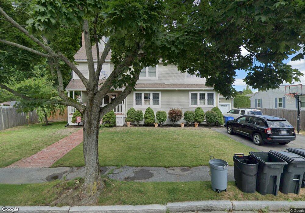
37 Whittier Ave Waltham, MA 02451
North Waltham NeighborhoodEstimated Value: $852,000 - $1,229,833
4
Beds
3
Baths
3,547
Sq Ft
$289/Sq Ft
Est. Value
About This Home
This home is located at 37 Whittier Ave, Waltham, MA 02451 and is currently estimated at $1,026,208, approximately $289 per square foot. 37 Whittier Ave is a home located in Middlesex County with nearby schools including Douglas Macarthur Elementary School, John F Kennedy Middle School, and Waltham Sr High School.
Ownership History
Date
Name
Owned For
Owner Type
Purchase Details
Closed on
Jun 19, 2019
Sold by
Agostino Rockelle E and Agostino Joseph M
Bought by
Agostino Ft
Current Estimated Value
Purchase Details
Closed on
Oct 2, 2000
Sold by
Dinsmore Phyllis E
Bought by
Agostino Joseph M
Create a Home Valuation Report for This Property
The Home Valuation Report is an in-depth analysis detailing your home's value as well as a comparison with similar homes in the area
Home Values in the Area
Average Home Value in this Area
Purchase History
| Date | Buyer | Sale Price | Title Company |
|---|---|---|---|
| Agostino Ft | -- | None Available | |
| Agostino Joseph M | $280,500 | -- |
Source: Public Records
Mortgage History
| Date | Status | Borrower | Loan Amount |
|---|---|---|---|
| Previous Owner | Agostino Joseph M | $350,000 | |
| Previous Owner | Agostino Joseph M | $350,000 |
Source: Public Records
Tax History Compared to Growth
Tax History
| Year | Tax Paid | Tax Assessment Tax Assessment Total Assessment is a certain percentage of the fair market value that is determined by local assessors to be the total taxable value of land and additions on the property. | Land | Improvement |
|---|---|---|---|---|
| 2025 | $9,378 | $955,000 | $443,400 | $511,600 |
| 2024 | $8,969 | $930,400 | $423,800 | $506,600 |
| 2023 | $8,880 | $860,500 | $384,600 | $475,900 |
| 2022 | $8,893 | $798,300 | $345,300 | $453,000 |
| 2021 | $8,827 | $779,800 | $345,300 | $434,500 |
| 2020 | $8,626 | $721,800 | $321,800 | $400,000 |
| 2019 | $8,220 | $649,300 | $317,800 | $331,500 |
| 2018 | $7,459 | $591,500 | $294,300 | $297,200 |
| 2017 | $7,084 | $564,000 | $266,800 | $297,200 |
| 2016 | $6,711 | $548,300 | $251,100 | $297,200 |
| 2015 | $6,474 | $493,100 | $219,700 | $273,400 |
Source: Public Records
Map
Nearby Homes
- 14 Benjamin Rd
- 1105 Lexington St Unit 102
- 15 Kings Way Unit 25
- 98 Seminole Ave
- 30 Wampum Ave
- 249 Lake St
- 234 Lake St
- 30 Jacqueline Rd Unit C
- 129 Lake St
- 463 Lincoln St
- 5 April Ln Unit 12
- 14 Piedmont Ave
- 102 Milner St
- 311 Concord Ave
- 92 Milner St
- 28 Hillcrest St
- 65 Montclair Ave
- 11 Autumn Ln
- 87 Clocktower Dr Unit 2207
- 107 Clocktower Dr Unit 3302
- 31 Whittier Ave
- 31 Whittier Ave
- 31 Whittier Ave Unit 1
- 55 Whittier Ave
- 38 Brewster Rd
- 44 Brewster Rd
- 32 Brewster Rd
- 40 Whittier Ave
- 32 Whittier Ave
- 23 Whittier Ave
- 48 Whittier Ave
- 24 Brewster Rd
- 26 Whittier Ave
- 17 Whittier Ave
- 56 Whittier Ave
- 56 Whittier Ave Unit A
- 56 Whittier Ave Unit B2
- 39 Brewster Rd
- 1235 Trapelo Rd
- 31 Brewster Rd