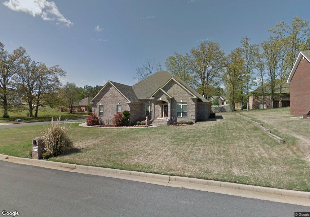
3708 Marchbanks Cir Jonesboro, AR 72401
Estimated Value: $333,391 - $389,000
--
Bed
3
Baths
2,740
Sq Ft
$135/Sq Ft
Est. Value
About This Home
This home is located at 3708 Marchbanks Cir, Jonesboro, AR 72401 and is currently estimated at $368,848, approximately $134 per square foot. 3708 Marchbanks Cir is a home located in Craighead County with nearby schools including Nettleton High School, Montessori School of Jonesboro, and Blessed Sacrament School.
Ownership History
Date
Name
Owned For
Owner Type
Purchase Details
Closed on
Oct 21, 2005
Sold by
Barker Doug and Barker Deana
Bought by
Brown Bobby M and Brown Sherry L
Current Estimated Value
Home Financials for this Owner
Home Financials are based on the most recent Mortgage that was taken out on this home.
Original Mortgage
$225,000
Outstanding Balance
$124,382
Interest Rate
5.37%
Mortgage Type
Construction
Estimated Equity
$244,466
Purchase Details
Closed on
Apr 28, 2004
Bought by
Barker
Create a Home Valuation Report for This Property
The Home Valuation Report is an in-depth analysis detailing your home's value as well as a comparison with similar homes in the area
Home Values in the Area
Average Home Value in this Area
Purchase History
| Date | Buyer | Sale Price | Title Company |
|---|---|---|---|
| Brown Bobby M | $36,000 | Lenders Title Co | |
| Barker | $38,000 | -- |
Source: Public Records
Mortgage History
| Date | Status | Borrower | Loan Amount |
|---|---|---|---|
| Open | Brown Bobby M | $225,000 |
Source: Public Records
Tax History Compared to Growth
Tax History
| Year | Tax Paid | Tax Assessment Tax Assessment Total Assessment is a certain percentage of the fair market value that is determined by local assessors to be the total taxable value of land and additions on the property. | Land | Improvement |
|---|---|---|---|---|
| 2025 | $2,945 | $63,690 | $9,600 | $54,090 |
| 2024 | $2,945 | $63,690 | $9,600 | $54,090 |
| 2023 | $2,312 | $63,690 | $9,600 | $54,090 |
| 2022 | $2,237 | $63,690 | $9,600 | $54,090 |
| 2021 | $2,186 | $53,300 | $7,600 | $45,700 |
| 2020 | $2,186 | $53,300 | $7,600 | $45,700 |
| 2019 | $2,186 | $53,300 | $7,600 | $45,700 |
| 2018 | $2,211 | $53,300 | $7,600 | $45,700 |
| 2017 | $2,192 | $53,300 | $7,600 | $45,700 |
| 2016 | $2,071 | $50,390 | $7,600 | $42,790 |
| 2015 | $2,071 | $50,390 | $7,600 | $42,790 |
| 2014 | $2,071 | $50,390 | $7,600 | $42,790 |
Source: Public Records
Map
Nearby Homes
- 500 N Airport
- 610 Airport Rd
- 4064 Gabriel Ct
- 4007 Sandra Ln
- 3708 Aggie Rd
- 4110 Tealwood Dr
- 208 Lake Dr
- 4400 Aggie Rd
- 4141 Bobcat Meadow Ln
- 341 Wolf Den Dr
- 4145 Bobcat Meadow Ln
- 3522 Bess Dr
- 3502 Burdyshaw Dr
- 4120 Lynx Ln
- 4201 Lynx Ln
- 4110 Willow Ridge Dr
- 4124 Cypress Moss Rd
- 4701 Edgemont Dr
- 1008 Cypress Pointe Cove
- 4012 Willow Pointe Dr
- 3704 Marchbanks Cir
- Lot 12 Marchbanks
- Lot 7 Marchbanks
- Lot 9 Marchbanks
- 3900 Marchbanks Cir
- 3805 Marchbanks Cir
- 3904 Marchbanks Cir
- 3709 Marchbanks Cir
- 3713 Marchbanks Cir
- 3801 Marchbanks Cir
- 3705 Marchbanks Cir
- 3700 Marchbanks Cir
- 3717 Marchbanks Cir
- 3813 Marchbanks Cir
- 0 Marchbanks Cir
- 3908 Marchbanks Cir
- 3701 Marchbanks Cir
- 3905 Marchbanks Cir
- 3901 Marchbanks Cir
- 3909 Marchbanks Cir