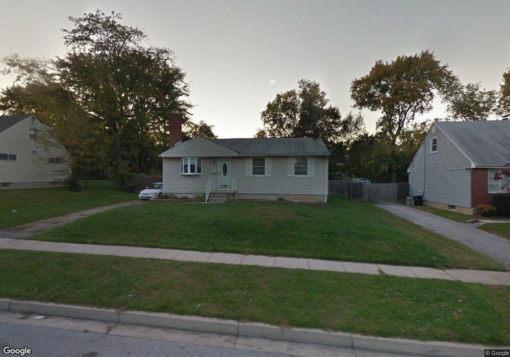
3708 Offutt Rd Randallstown, MD 21133
Estimated Value: $330,064 - $372,000
--
Bed
2
Baths
1,336
Sq Ft
$258/Sq Ft
Est. Value
About This Home
This home is located at 3708 Offutt Rd, Randallstown, MD 21133 and is currently estimated at $345,016, approximately $258 per square foot. 3708 Offutt Rd is a home located in Baltimore County with nearby schools including Randallstown Elementary School, Deer Park Middle Magnet School, and Randallstown High School.
Ownership History
Date
Name
Owned For
Owner Type
Purchase Details
Closed on
Jun 30, 2022
Sold by
Michele Brown
Bought by
Brown Michele
Current Estimated Value
Purchase Details
Closed on
Sep 28, 2017
Sold by
Brown Michele
Bought by
Brown Michele and Brown Michael D
Purchase Details
Closed on
Jun 23, 1999
Sold by
Butler Emanuel
Bought by
Brown Michael D and Brown Michele
Purchase Details
Closed on
Jun 10, 1986
Sold by
Saltsman Robert H W
Bought by
Butler Emanuel
Create a Home Valuation Report for This Property
The Home Valuation Report is an in-depth analysis detailing your home's value as well as a comparison with similar homes in the area
Home Values in the Area
Average Home Value in this Area
Purchase History
| Date | Buyer | Sale Price | Title Company |
|---|---|---|---|
| Brown Michele | -- | Greenwood Title | |
| Brown Michele | -- | Greenwood Title | |
| Brown Michele | -- | Greenwood Title Inc | |
| Brown Michael D | $103,900 | -- | |
| Butler Emanuel | $75,000 | -- |
Source: Public Records
Tax History Compared to Growth
Tax History
| Year | Tax Paid | Tax Assessment Tax Assessment Total Assessment is a certain percentage of the fair market value that is determined by local assessors to be the total taxable value of land and additions on the property. | Land | Improvement |
|---|---|---|---|---|
| 2025 | $3,265 | $258,933 | -- | -- |
| 2024 | $3,265 | $241,000 | $74,300 | $166,700 |
| 2023 | $1,587 | $229,367 | $0 | $0 |
| 2022 | $2,997 | $217,733 | $0 | $0 |
| 2021 | $2,701 | $206,100 | $56,300 | $149,800 |
| 2020 | $2,701 | $205,467 | $0 | $0 |
| 2019 | $3,214 | $204,833 | $0 | $0 |
| 2018 | $3,214 | $204,200 | $56,300 | $147,900 |
| 2017 | $2,420 | $185,133 | $0 | $0 |
| 2016 | $2,226 | $166,067 | $0 | $0 |
| 2015 | $2,226 | $147,000 | $0 | $0 |
| 2014 | $2,226 | $147,000 | $0 | $0 |
Source: Public Records
Map
Nearby Homes
- 3510 Tali Dr
- 9202 Samoset Rd
- 3705 Allenswood Ct
- 9124 Liberty Rd
- 9044 Allenswood Rd
- 9303 Samoset Rd
- 3805 Terka Cir
- 3506 Bayer Ave
- 3816 Cassandra Rd
- 3822 Cassandra Rd
- 3709 Fieldstone Rd
- 3823 Cassandra Rd
- 3418 Carroll Ave
- 3402 Offutt Rd
- 9112 Meadow Heights Rd
- 3714 Stoneybrook Rd
- 3332 Offutt Rd
- 1 Rock Story Ct
- 3618 Briarstone Rd
- 3320 Offutt Rd