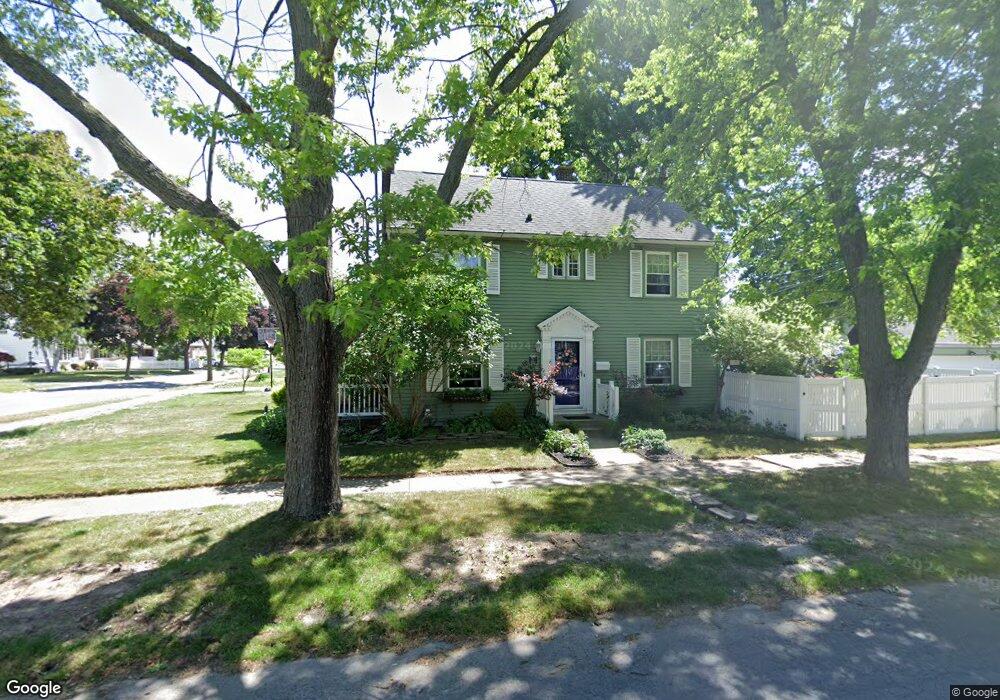
371 Bennett St North Tonawanda, NY 14120
Estimated Value: $262,000 - $290,000
3
Beds
2
Baths
1,552
Sq Ft
$179/Sq Ft
Est. Value
About This Home
This home is located at 371 Bennett St, North Tonawanda, NY 14120 and is currently estimated at $278,339, approximately $179 per square foot. 371 Bennett St is a home located in Niagara County with nearby schools including North Tonawanda Intermediate School, St Matthew Lutheran School, and New Life Christian School.
Ownership History
Date
Name
Owned For
Owner Type
Purchase Details
Closed on
May 24, 2010
Sold by
Bush Todd and Bush Danielle
Bought by
Blenk William P and Dibernardo Diane C
Current Estimated Value
Home Financials for this Owner
Home Financials are based on the most recent Mortgage that was taken out on this home.
Original Mortgage
$35,000
Interest Rate
4.45%
Mortgage Type
New Conventional
Purchase Details
Closed on
Nov 20, 2003
Sold by
Marton Nathan
Bought by
Bush Todd
Purchase Details
Closed on
May 23, 1996
Sold by
Doebler David C and Doebler Judith M
Bought by
Marton Nathan R and Demler Mary Alice
Create a Home Valuation Report for This Property
The Home Valuation Report is an in-depth analysis detailing your home's value as well as a comparison with similar homes in the area
Home Values in the Area
Average Home Value in this Area
Purchase History
| Date | Buyer | Sale Price | Title Company |
|---|---|---|---|
| Blenk William P | $128,000 | None Available | |
| Bush Todd | $114,000 | Patricia George | |
| Marton Nathan R | $93,000 | -- |
Source: Public Records
Mortgage History
| Date | Status | Borrower | Loan Amount |
|---|---|---|---|
| Closed | Blenk William P | $35,000 |
Source: Public Records
Tax History Compared to Growth
Tax History
| Year | Tax Paid | Tax Assessment Tax Assessment Total Assessment is a certain percentage of the fair market value that is determined by local assessors to be the total taxable value of land and additions on the property. | Land | Improvement |
|---|---|---|---|---|
| 2024 | $4,128 | $116,900 | $15,300 | $101,600 |
| 2023 | $4,025 | $116,900 | $15,300 | $101,600 |
| 2022 | $3,532 | $116,900 | $15,300 | $101,600 |
| 2021 | $3,483 | $116,900 | $15,300 | $101,600 |
| 2020 | $3,362 | $116,900 | $15,300 | $101,600 |
| 2019 | $1,602 | $116,900 | $15,300 | $101,600 |
| 2018 | $3,292 | $116,900 | $15,300 | $101,600 |
| 2017 | $3,217 | $116,900 | $15,300 | $101,600 |
| 2016 | $3,125 | $116,900 | $15,300 | $101,600 |
| 2015 | -- | $116,900 | $15,300 | $101,600 |
| 2014 | -- | $116,900 | $15,300 | $101,600 |
Source: Public Records
Map
Nearby Homes
- 3947 Wheatfield St
- 3941 Wheatfield St
- 3911 Wheatfield St
- 203 Edward St
- 84 Klaum Ave
- 114 Keil St
- 417 Robinson St
- 228 Robinson St
- 512 Oliver St
- 104 Oakwood Terrace
- 513 Euclid Ave
- 51 Ritchie Lot #2 Ave
- 125 7th Ave
- 415 Oliver St
- 364 Schenck St
- 120 7th Ave
- 385 Oliver St
- 843 Payne Ave
- 29 1st Ave
- 34 2nd Ave