


371 Dug Rd Monticello, KY 42633
Estimated payment $6,822/month
Highlights
- View of Trees or Woods
- 50.73 Acre Lot
- Gentle Sloping Lot
About This Lot
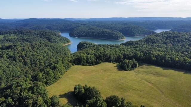
Looking for acreage close to Lake Cumberland!! Check out this hard to find, large tract of land that consists of 50.73 acres. Half of the acreage is cleared and the other half in timber. This property backs up to CORP property, making the location great for a campground, or your own private residence. Property is within 2 miles to Safe Harbor, (Beaver Creek Dock), less than 1/2 mile to boat ramp at the end of Dug Road (known as the orchard) less than 8 miles from Monticello, for shopping, medical, schools, etc. Call today to take a look at this larger tract of land.
Property Details
Property Type
- Land
Est. Annual Taxes
- $133
Lot Details
- 50.73 Acre Lot
- Gentle Sloping Lot
Property Views
- Woods
- Farm
- Mountain
- Rural
Schools
- Wayne Co Elementary And Middle School
- Not Applicable Middle School
- Wayne Co High School
Utilities
- Sewer Not Available
Community Details
- Rural Subdivision
Listing and Financial Details
- Assessor Parcel Number 025-00-00-054.00
Map
Home Values in the Area
Average Home Value in this Area
Tax History
| Year | Tax Paid | Tax Assessment Tax Assessment Total Assessment is a certain percentage of the fair market value that is determined by local assessors to be the total taxable value of land and additions on the property. | Land | Improvement |
|---|---|---|---|---|
| 2024 | $133 | $14,704 | $0 | $0 |
| 2023 | $139 | $14,704 | $0 | $0 |
| 2022 | $499 | $52,350 | $13,600 | $38,750 |
| 2021 | $502 | $52,350 | $13,600 | $38,750 |
| 2020 | $508 | $52,350 | $13,600 | $38,750 |
| 2019 | $509 | $52,350 | $13,600 | $38,750 |
| 2018 | $507 | $52,350 | $13,600 | $38,750 |
| 2017 | $510 | $52,350 | $0 | $0 |
| 2016 | $483 | $52,350 | $13,600 | $38,750 |
| 2015 | $475 | $52,350 | $13,600 | $38,750 |
| 2012 | $452 | $52,350 | $13,600 | $38,750 |
Property History
| Date | Event | Price | Change | Sq Ft Price |
|---|---|---|---|---|
| 03/24/2025 03/24/25 | For Sale | $1,250,000 | 0.0% | -- |
| 02/21/2025 02/21/25 | Off Market | $1,250,000 | -- | -- |
| 08/22/2024 08/22/24 | For Sale | $1,250,000 | -- | -- |
Source: ImagineMLS (Bluegrass REALTORS®)
MLS Number: 24017677
APN: 025-00-00-054.00
Disclaimer: Certain information contained herein is derived from information provided by parties other than Homes.com. All information provided is deemed reliable, but is not guaranteed to be accurate and should be independently verified.
![]() The information is being provided by LBAR Multiple Listing Service. Information deemed reliable but not guaranteed. Information is provided for consumers' personal, non-commercial use, and may not be used for any purpose other than the identification of potential properties for purchase. Copyright 2025 LBAR Multiple Listing Service. All Rights Reserved.
The information is being provided by LBAR Multiple Listing Service. Information deemed reliable but not guaranteed. Information is provided for consumers' personal, non-commercial use, and may not be used for any purpose other than the identification of potential properties for purchase. Copyright 2025 LBAR Multiple Listing Service. All Rights Reserved.
- 25 Cart Bell Ln
- 4-7 Cart Bell Ridge Rd
- 567 Cart Bell Ridge Rd
- 613 Webster Spradlin Rd
- 641 Webster Spradlin Rd
- 500 Beaver Lodge Rd
- Lots 18-21 Harmony Ln
- 114 Blevins Ridge Rd
- 1560 Bell Phipps Rd
- 1119 Harmon Creek Rd
- 9999 Cr-1479
- 144 Lakewood Dr
- 219 Bell Phipps Rd
- 116 Waters Edge Trail
- 9999 George Garner Rd
- 1692 Sandstone Point Trail Lot#136
- 132 Sandstone Point Trail
- Lot 128 Sandstone Point Trail
- 000 Sandstone Point Trail
- Lot 35 Sandstone Point Trail
- 112 State Highway 1611
- 98 State Highway 1611
- 30 Lakeland Dr Unit 1
- 6399 Ky-196 Unit 3
- 495 Jamestown St
- 51 Lee's Ford Dock Rd Unit 104
- 165 Goad Ln
- 5340 Beechwood Dr Unit 2
- 386 Parkers Mill Way
- B2 Nasim Way Unit 10
- 11 Midland Meadow
- 1155 Kentucky 3057 Unit C4
- 1588 Joe Scott Rd
- 406 N Main St
- 1633 Kentucky 1247 Unit B
- 1633 Kentucky 1247 Unit A
- 1611 Kentucky 1247 Unit C
- 1611 Kentucky 1247 Unit B
- 1611 Kentucky 1247 Unit A
- 1613 Kentucky 1247 Unit B
