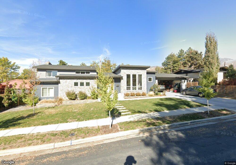
371 E 1600 S Bountiful, UT 84010
Estimated Value: $531,000 - $635,951
5
Beds
3
Baths
2,395
Sq Ft
$243/Sq Ft
Est. Value
About This Home
This home is located at 371 E 1600 S, Bountiful, UT 84010 and is currently estimated at $582,238, approximately $243 per square foot. 371 E 1600 S is a home located in Davis County with nearby schools including Valley View School, Mueller Park Junior High School, and Bountiful High School.
Ownership History
Date
Name
Owned For
Owner Type
Purchase Details
Closed on
Jun 16, 2004
Sold by
Lords Nancy O
Bought by
Jenkins Christopher and Jenkins Adriel
Current Estimated Value
Home Financials for this Owner
Home Financials are based on the most recent Mortgage that was taken out on this home.
Original Mortgage
$153,589
Outstanding Balance
$74,987
Interest Rate
6.09%
Mortgage Type
FHA
Estimated Equity
$507,252
Create a Home Valuation Report for This Property
The Home Valuation Report is an in-depth analysis detailing your home's value as well as a comparison with similar homes in the area
Purchase History
| Date | Buyer | Sale Price | Title Company |
|---|---|---|---|
| Jenkins Christopher | -- | Founders Title Company |
Source: Public Records
Mortgage History
| Date | Status | Borrower | Loan Amount |
|---|---|---|---|
| Open | Jenkins Christopher | $153,589 |
Source: Public Records
Tax History
| Year | Tax Paid | Tax Assessment Tax Assessment Total Assessment is a certain percentage of the fair market value that is determined by local assessors to be the total taxable value of land and additions on the property. | Land | Improvement |
|---|---|---|---|---|
| 2025 | $3,407 | $313,500 | $128,836 | $184,664 |
| 2024 | $3,188 | $303,600 | $114,105 | $189,495 |
| 2023 | $3,064 | $529,000 | $210,908 | $318,092 |
| 2022 | $3,246 | $308,000 | $115,431 | $192,569 |
| 2021 | $2,851 | $400,000 | $151,027 | $248,973 |
| 2020 | $2,446 | $355,000 | $129,258 | $225,742 |
| 2019 | $2,573 | $353,000 | $138,203 | $214,797 |
| 2018 | $2,341 | $327,000 | $135,511 | $191,489 |
| 2016 | $1,473 | $108,625 | $47,340 | $61,285 |
| 2015 | $1,534 | $98,945 | $47,340 | $51,605 |
| 2014 | $1,460 | $104,920 | $47,340 | $57,580 |
| 2013 | -- | $104,462 | $51,700 | $52,762 |
Source: Public Records
Map
Nearby Homes
- 380 E 1500 S
- 288 E 1650 S
- 141 E 1650 S
- 285 E 1100 S
- 631 E 1700 S
- 1886 S Jeri Dr
- 1761 S Davis Blvd
- 2059 S 350 E Unit 6
- 795 Abby Ln Unit 5
- 2038 S 350 E Unit 3
- 295 E 2050 S Unit 1
- 2046 S 350 E Unit 4
- 296 E 2050 S Unit 2
- 775 E 1500 S
- 2053 S 350 E Unit 7
- 1820 S 50 W
- 188 E 2050 S Unit D3
- 2064 S Orchard Dr
- 320 E 2100 S
- 861 E Millbrook Way
Your Personal Tour Guide
Ask me questions while you tour the home.