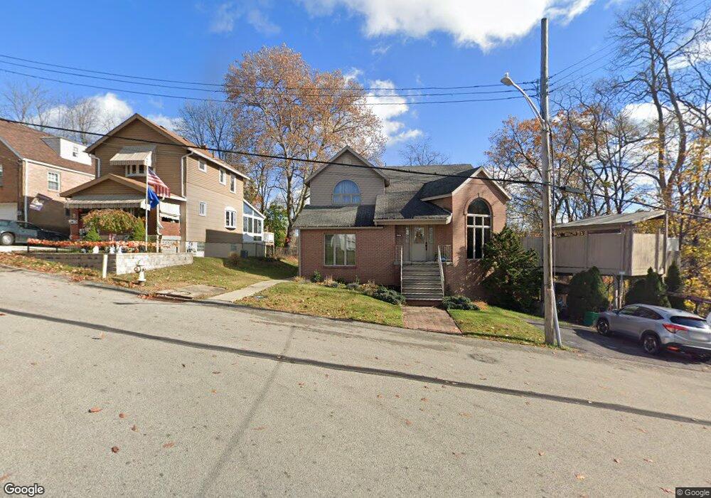
3717 Harvey St Homestead, PA 15120
Estimated Value: $205,000 - $236,467
2
Beds
1
Bath
925
Sq Ft
$236/Sq Ft
Est. Value
About This Home
This home is located at 3717 Harvey St, Homestead, PA 15120 and is currently estimated at $218,117, approximately $235 per square foot. 3717 Harvey St is a home located in Allegheny County with nearby schools including Steel Valley Senior High School and St. Therese School.
Ownership History
Date
Name
Owned For
Owner Type
Purchase Details
Closed on
Jul 7, 2023
Sold by
Canofari Donald
Bought by
Lanum Serena
Current Estimated Value
Purchase Details
Closed on
Aug 9, 2018
Sold by
Shaw Robert J and Schuessler William C
Bought by
Canofari Donald and Canofari Constance A
Home Financials for this Owner
Home Financials are based on the most recent Mortgage that was taken out on this home.
Original Mortgage
$121,499
Interest Rate
4.5%
Mortgage Type
New Conventional
Purchase Details
Closed on
Feb 8, 2018
Sold by
The Estate Of Dwight Curtis Porter Decea
Bought by
Shaw Robert J and Schuessler William C
Purchase Details
Closed on
Feb 25, 1959
Bought by
Porter Dwight C and Porter Eleanor M
Create a Home Valuation Report for This Property
The Home Valuation Report is an in-depth analysis detailing your home's value as well as a comparison with similar homes in the area
Home Values in the Area
Average Home Value in this Area
Purchase History
| Date | Buyer | Sale Price | Title Company |
|---|---|---|---|
| Lanum Serena | $225,000 | -- | |
| Lanum Serena | $225,000 | -- | |
| Canofari Donald | $145,000 | Attorney | |
| Shaw Robert J | $55,000 | Attorney | |
| Porter Dwight C | -- | -- |
Source: Public Records
Mortgage History
| Date | Status | Borrower | Loan Amount |
|---|---|---|---|
| Previous Owner | Canofari Donald | $121,499 |
Source: Public Records
Tax History Compared to Growth
Tax History
| Year | Tax Paid | Tax Assessment Tax Assessment Total Assessment is a certain percentage of the fair market value that is determined by local assessors to be the total taxable value of land and additions on the property. | Land | Improvement |
|---|---|---|---|---|
| 2025 | $5,772 | $125,000 | $18,100 | $106,900 |
| 2024 | $5,772 | $125,000 | $18,100 | $106,900 |
| 2023 | $5,555 | $125,000 | $18,100 | $106,900 |
| 2022 | $5,199 | $125,000 | $18,100 | $106,900 |
| 2021 | $5,070 | $125,000 | $18,100 | $106,900 |
| 2020 | $2,969 | $125,000 | $18,100 | $106,900 |
| 2019 | $2,915 | $74,800 | $18,100 | $56,700 |
| 2018 | $188 | $56,800 | $18,100 | $38,700 |
| 2017 | $2,130 | $56,800 | $18,100 | $38,700 |
| 2016 | $269 | $56,800 | $18,100 | $38,700 |
| 2015 | $269 | $56,800 | $18,100 | $38,700 |
| 2014 | $2,090 | $56,800 | $18,100 | $38,700 |
Source: Public Records
Map
Nearby Homes
- 3904 Shady Ave
- 3915 Davis Ave
- 125 Red Oak Ln
- 4538 Woodhill Dr
- 3907 McWhinney St
- 4005 Davis Ave
- 3740 Superior St
- 4409 Woodhill Dr
- 4374 Homestead Duquesne Rd
- 4366 Homestead Duquesne Rd
- 4140 Fairfield Ave
- 3612 Main St
- 3316 Valewood Dr
- 224 Mercer Ave
- 3415 Alberta St
- 314 W Lehigh St
- 4800 Brierly Dr W
- 317 Tioga St
- 4817 Clover Ln
- 4647 W Run Rd
- 3717 Harvey Avenue Extension
- 3711 Harvey St
- 3723 Harvey St
- 3707 Harvey St
- 3720 Shady Ave
- 3714 Shady Ave
- 3724 Shady Ave
- 3720 Harvey Avenue Extension
- 3708 Shady Ave
- 3716 Harvey Avenue Extension
- 3720 Harvey St
- 3701 Harvey Avenue Extension
- 3701 Harvey St
- 3730 Shady Ave
- 3716 Harvey St
- 3716 Harvey Ave
- 3800 Shady Ave
- 3702 Shady Ave
- 3712 Harvey St
- 3724 Harvey St