NOT LISTED FOR SALE

3719 Will Thompson Rd Walling, TN 38587

Estimated Value: $526,000 - $980,448

100 Acres
$7,532 Price per Acre
4,356,000 Sq Ft Lot

Last Sold October 30, 2017

Last sale price $400,000

Est. 88% increase in value since last sale

Current estimated payment $4,455/month

Highlights

  • Lake Front
  • Home fronts a pond
  • No HOA
  • Horse Property
  • 100 Acre Lot
  • Views

About This Lot

As of October 2017

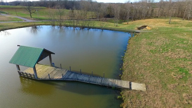
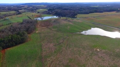
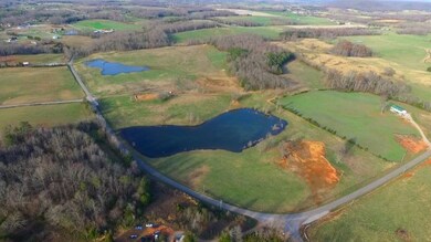
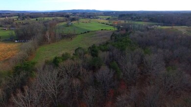
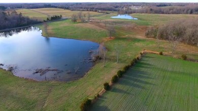
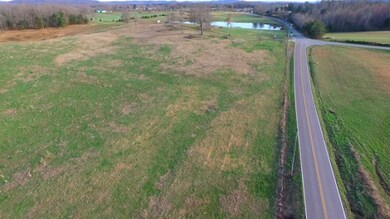
Rare opportunity to own the most picturesque 100 acre farm with over a half mile of road frontage and mostly pasture. The farm has one 3 acre lake and one 4 acre lake. Middle Tennessee vies are everywhere on this farm and it is fenced. There is nothing like this on the market!

Last Listed By

Landon Dickerson

Tri-star Real Estate & Auction Co., Brokerage Phone: 9318362259 License #290910 Listed on: 03/14/2017

Property Details

Property Type

  • Land

Est. Annual Taxes

  • $468

Year Built

  • 2022

Lot Details

  • 100 Acre Lot
  • Home fronts a pond
  • Lake Front
  • Property fronts a county road
  • Lot Has A Rolling Slope

Additional Features

  • Property Views

Listing and Financial Details

  • Assessor Parcel Number 18.02

Community Details

Overview

  • No Home Owners Association

Recreation

  • Horse Property

Property Details

Property Type

Land

Est. Annual Taxes

$468

Year Built

2022

Lot Details

0

Listing Details

  • Attribution Contact: 9318362259
  • Directions: FROM WCCH: TAKE WEST BOCKMAN/SMITHVILLE HIGHWAY TO LEFT ON WILL THOMPSON, GO PAST CASSVILLE SCHOOL, STAY STRAIGHT AT STOP SIGN AND TRAVEL ABOUT 3 AND A HALF MILES TO PROPERTY ON LEFT. NO SIGNS
  • Prop. Type: Land
  • Property Sub Type: Farm
  • Horses: Yes
  • Lot Size Acres: 100
  • Lot Size: 100 ACRES
  • Road Frontage Type: County Road
  • Road Surface Type: Paved
  • Subdivision Name: None
  • Special Features: None
  • Year Built (Public Record): 2022

Interior Features

  • Possible Use: Farm

Exterior Features

  • Topography: Rolling
  • Lot Features: Horse Property
  • View: Private-Individually Owned
  • View: Yes
  • Waterfront Features: Lake, Pond, Private-Individually Owned
  • Waterfront: Yes

Utilities

  • Electric: CANEY FORK
  • Sewer: None
  • Gas Company: MTNG
  • Water Source: Utility, DEWHITE

Condo/Co-op/Association

  • Association: No

Lot Info

  • Lot Size Sq Ft: 4356000
  • Farm Land Area Units: Square Feet
  • Wooded Area: 871200
  • Parcel #: 18.02
  • Irrigation Water Rights: No

Tax Info

  • Tax Annual Amount: 467.91
  • Tax Book Number: 37
  • Tax Map Number: 62

Ownership History

Date Name Owned For Owner Type

Purchase Details

Closed on
May 28, 2019
Sold by
Clouse Properties Inc
Bought by
Snyder Patrick
Total Days on Market
0
Current Estimated Value
$753,224

Home Financials for this Owner

Home Financials are based on the most recent Mortgage that was taken out on this home.
Original Mortgage
$175,000
Outstanding Balance
$156,077
Interest Rate
4.1%
Mortgage Type
New Conventional
Estimated Equity
$510,557

Purchase Details

Closed on
Jun 1, 1996
Bought by
Howard William T and Howard Terri L

Purchase Details

Closed on
Dec 12, 1983
Bought by
Rutledge William and Rutledge Donna

Range of Values:

Collateral Analytics

Collateral Analytics Collateral Analytics AVMs (Automated Valuation Model) employ a number of statistical approaches combined with neighborhood-specific comparable selection guarantees the most up-to-date and precise valuations.

Not Available

Collateral Analytics does not have data for the current month. Please view the chart for historical values.

ICE

ICE Mortgage Technology ICE Mortgage Technology’s AVM (Automated Valuation Model) is a state-of-the-art online residential property valuation tool that provides a quick and accurate estimate of the value of almost any home in the U.S.

Not Available

ICE Mortgage Technology does not have data for the current month. Please view the chart for historical values.

First American

First American First American Data & Analytics’ next-generation AVM combines unrivaled data assets with a blended ensemble of valuation models to produce highly accurate, reliable valuations you can trust.

Not Available

First American does not have data for the current month. Please view the chart for historical values.

Quantarium

Quantarium Quantarium’s valuation service, repeatedly proven the industry’s most accurate and comprehensive, is supercharged with a self-learning and auto-tuning AI engine that continually becomes smarter and more accurate as it processes daily inputs from the industry’s leading RE data lake.

Not Available

Quantarium does not have data for the current month. Please view the chart for historical values.

Average Value
Not Available
List Price
Sold Price
Create a Home Valuation Report for This Property
The Home Valuation Report is an in-depth analysis detailing your home's value as well as a comparison with similar homes in the area

Similar Property in Walling, TN

  • 0 Gum Spring Rd, Walling, TN 38587

    $935,000

    • Land
    • 94 Acres
    • $10,000 per Acre
    • 0 Gum Spring Rd
    • Walling, TN

    Discover a once-in-a-lifetime opportunity to own this stunning 93.5-acre farm, nestled just minutes from Center Hill Lake, Rock Island State Park, and the Caney Fork River. This picturesque property boasts a large private lake, offering serene views and endless recreational possibilities. Fully fenced and ready for livestock, the farm is ideal for agricultural pursuits or a private retreat.

    Tony Luna Lake Homes Realty, LLC

    Section Image

Home Values in the Area

Source: Public Records

Average Home Value in this Area


Source: Public Records

Purchase History

Date Buyer Sale Price Title Company
Snyder Patrick $200,000 None Available
Howard William T $135,000 --
Rutledge William -- --
Source: Public Records

Mortgage History

Date Status Borrower Loan Amount
Open Snyder Patrick $175,000
Previous Owner Clement Dennis J $400,000
Source: Public Records

Property History

Date Event Price Change Sq Ft Price
10/30/2017 10/30/17 Sold $400,000 0.0% --
01/01/1970 01/01/70 Off Market $400,000 -- --
Source: Upper Cumberland Association of REALTORS®

Tax History Compared to Growth

Source: Public Records

Tax History

Year Tax Paid Tax Assessment Tax Assessment Total Assessment is a certain percentage of the fair market value that is determined by local assessors to be the total taxable value of land and additions on the property. Land Improvement
2024 $3,345 $163,175 $13,375 $149,800
2023 $3,761 $163,175 $13,375 $149,800
2022 $2,748 $134,050 $33,675 $100,375
2021 $651 $31,750 $31,750 $0
2020 $651 $31,750 $31,750 $0
2019 $632 $30,825 $30,825 $0
2018 $1,567 $30,825 $30,825 $0
2017 $399 $76,425 $76,425 $0
2016 $468 $22,825 $21,625 $1,200
2015 $422 $22,825 $21,625 $1,200
2014 -- $22,825 $21,625 $1,200
2013 -- $23,275 $20,900 $2,375
Source: Public Records

Agents Affiliated with this Home

  • Section Image
See All Agents

Map

Source: Upper Cumberland Association of REALTORS®

MLS Number: 179441

Upper Cumberland Association of REALTORS®

APN: 062-018.02