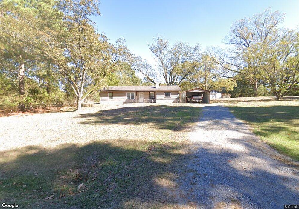
372 Barnes Rd West Monroe, LA 71291
Estimated Value: $178,000 - $208,000
2
Beds
2
Baths
1,252
Sq Ft
$152/Sq Ft
Est. Value
About This Home
This home is located at 372 Barnes Rd, West Monroe, LA 71291 and is currently estimated at $190,426, approximately $152 per square foot. 372 Barnes Rd is a home located in Ouachita Parish with nearby schools including Drew Elementary School, West Ridge Middle School, and West Monroe High School.
Ownership History
Date
Name
Owned For
Owner Type
Purchase Details
Closed on
May 12, 2020
Sold by
Arj Llc
Bought by
Bennett Johnny R
Current Estimated Value
Home Financials for this Owner
Home Financials are based on the most recent Mortgage that was taken out on this home.
Original Mortgage
$51,500
Outstanding Balance
$45,414
Interest Rate
3.5%
Mortgage Type
New Conventional
Estimated Equity
$145,012
Purchase Details
Closed on
Feb 4, 2019
Sold by
Cox James Joseph Est
Bought by
Arj Llc
Create a Home Valuation Report for This Property
The Home Valuation Report is an in-depth analysis detailing your home's value as well as a comparison with similar homes in the area
Purchase History
| Date | Buyer | Sale Price | Title Company |
|---|---|---|---|
| Bennett Johnny R | $171,500 | None Available | |
| Arj Llc | $105,000 | -- |
Source: Public Records
Mortgage History
| Date | Status | Borrower | Loan Amount |
|---|---|---|---|
| Open | Bennett Johnny R | $51,500 |
Source: Public Records
Tax History
| Year | Tax Paid | Tax Assessment Tax Assessment Total Assessment is a certain percentage of the fair market value that is determined by local assessors to be the total taxable value of land and additions on the property. | Land | Improvement |
|---|---|---|---|---|
| 2025 | $795 | $3,507 | $3,000 | $507 |
| 2024 | $795 | $15,690 | $3,000 | $12,690 |
| 2023 | $805 | $13,532 | $3,000 | $10,532 |
| 2022 | $1,215 | $13,532 | $3,000 | $10,532 |
| 2021 | $1,164 | $12,963 | $3,000 | $9,963 |
| 2020 | $1,164 | $12,963 | $3,000 | $9,963 |
| 2019 | $832 | $9,292 | $2,012 | $7,280 |
| 2018 | $832 | $9,292 | $2,012 | $7,280 |
| 2017 | $832 | $9,067 | $2,012 | $7,055 |
| 2016 | $832 | $8,580 | $1,300 | $7,280 |
| 2015 | $766 | $8,580 | $1,300 | $7,280 |
| 2014 | $766 | $8,580 | $1,300 | $7,280 |
| 2013 | $565 | $6,342 | $1,300 | $5,042 |
Source: Public Records
Map
Nearby Homes
- 108 Comanche Trail
- 121 Comanche Trail
- 111 Trace Cir
- 171 Chimney Hill Rd
- 1119 Comanche Trail
- 105 Bonnabel Place
- 107 Bonnabel Place
- 110 Fox Run Unit 110 Fox run
- 145 Preston Rd
- 000 Strozier Rd
- 865 Johnson Rd
- 885 Johnson Rd
- 106 Mohawk Cir
- 101 Greenbriar Dr
- 102 Boxwood Dr
- 159 Chapel Ln
- 205 Chapel Hill Place
- 102 W Standard Reed Rd
- 370 J T Griggs Rd
- 163 Lost Landing Rd
- 101 Trace West Rd
- 100 Trace West Rd
- 103 Cherokee Dr
- 101 Cherokee Dr
- 105 Cherokee Dr
- 107 Cherokee Dr
- 104 Trace West Rd
- 107 Trace West Rd
- 110 Trace West Rd
- 102 Cherokee Dr
- 515 Barnes Rd
- 106 Cherokee Dr
- 104 Cherokee Dr
- 146 Heron Trail
- 300 Barnes Rd
- 100 Cherokee Dr
- 115 Trace West Rd
- 144 Trace Rd W
- 336 Barnes Rd
- 136 Trace West Rd
Your Personal Tour Guide
Ask me questions while you tour the home.