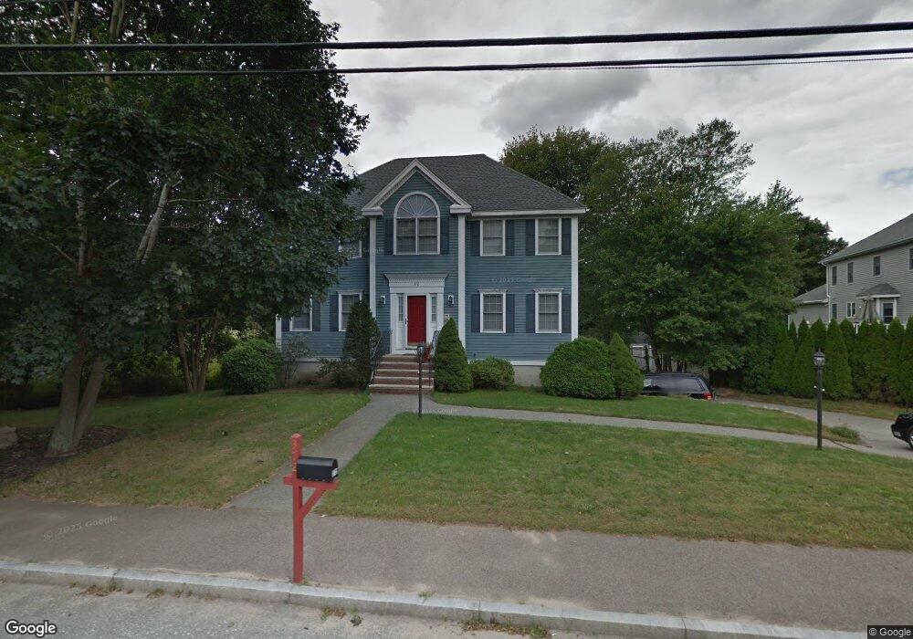
372 Main St Saugus, MA 01906
Oakland Vale NeighborhoodEstimated Value: $942,785 - $1,258,000
4
Beds
3
Baths
2,544
Sq Ft
$422/Sq Ft
Est. Value
About This Home
This home is located at 372 Main St, Saugus, MA 01906 and is currently estimated at $1,072,446, approximately $421 per square foot. 372 Main St is a home located in Essex County with nearby schools including Saugus High School, Pioneer Charter School Of Science II, and Melrose Montessori School.
Ownership History
Date
Name
Owned For
Owner Type
Purchase Details
Closed on
Dec 30, 2008
Sold by
Pisano Anthony and Pisano Ronald
Bought by
Pisano Ronald
Current Estimated Value
Purchase Details
Closed on
Jul 2, 1997
Sold by
Cedar Rt and Barbagallo Peter J
Bought by
Pisano Anthony and Pisano Natonetta
Create a Home Valuation Report for This Property
The Home Valuation Report is an in-depth analysis detailing your home's value as well as a comparison with similar homes in the area
Home Values in the Area
Average Home Value in this Area
Purchase History
| Date | Buyer | Sale Price | Title Company |
|---|---|---|---|
| Pisano Ronald | -- | -- | |
| Pisano Anthony | $273,000 | -- |
Source: Public Records
Mortgage History
| Date | Status | Borrower | Loan Amount |
|---|---|---|---|
| Open | Pisano Anthony | $50,000 | |
| Open | Pisano Anthony | $100,000 | |
| Previous Owner | Pisano Anthony | $153,400 | |
| Previous Owner | Pisano Anthony | $155,000 |
Source: Public Records
Tax History
| Year | Tax Paid | Tax Assessment Tax Assessment Total Assessment is a certain percentage of the fair market value that is determined by local assessors to be the total taxable value of land and additions on the property. | Land | Improvement |
|---|---|---|---|---|
| 2025 | $8,545 | $800,100 | $297,100 | $503,000 |
| 2024 | $8,125 | $762,900 | $270,100 | $492,800 |
| 2023 | $7,945 | $705,600 | $243,100 | $462,500 |
| 2022 | $7,425 | $618,200 | $222,400 | $395,800 |
| 2021 | $7,273 | $589,400 | $193,600 | $395,800 |
| 2020 | $6,860 | $575,500 | $184,600 | $390,900 |
| 2019 | $6,544 | $537,300 | $166,600 | $370,700 |
| 2018 | $6,104 | $527,100 | $162,100 | $365,000 |
| 2017 | $5,874 | $487,500 | $151,300 | $336,200 |
| 2016 | $6,665 | $546,300 | $247,700 | $298,600 |
| 2015 | $6,253 | $520,200 | $235,800 | $284,400 |
| 2014 | $5,792 | $498,900 | $235,800 | $263,100 |
Source: Public Records
Map
Nearby Homes
- 21 Athens Dr
- 86 Lynn Fells Pkwy
- 148 Forest St
- 348 Lynn Fells Pkwy
- 176 Bay State Rd
- 9 Ledge St
- 846 Broadway Unit 40
- 7 West St
- 9 Elmcrest Cir
- 89 Lovell Rd
- 905 Sherwood Forest Ln
- 921 Sherwood Forest Ln
- 801 Sherwood Forest Ln
- 7 Nirvana Dr
- 70 Old Nahant Rd
- 29 Susan Dr
- 128 Green St Unit 128
- 109 Linden Rd
- 12B Cheever Ave
- 12C Cheever Ave
Your Personal Tour Guide
Ask me questions while you tour the home.