372 Main St Setauket, NY 11733
Estimated payment $2,804/month
Highlights
- Colonial Architecture
- Minnesauke Elementary School Rated A
- 2 Car Garage
About This Home
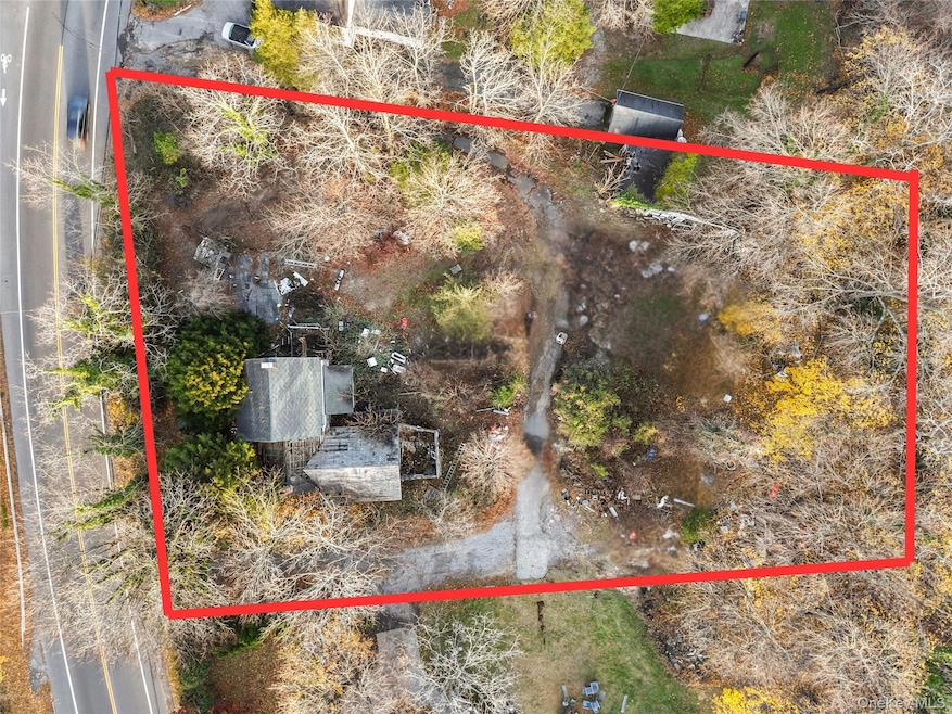
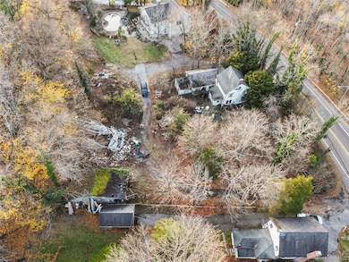
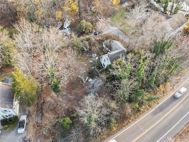
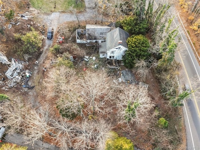
Situated in one of Suffolk County’s most coveted and prestigious communities, this rare opportunity offers unmatched value and potential on a sprawling .74-acre lot perched high on a scenic hill. As the lowest-priced property on the market in the entire area, this approximately 2,500 sq ft colonial with a detached 2-car garage is ideal for investors, builders, or buyers looking to fully renovate or reimagine a home from the ground up. The setting provides exceptional privacy, an elevated vantage point, and the chance to create a true private oasis on an oversized parcel—an offering that is nearly impossible to find at this price point. The home requires a full renovation throughout, but the footprint, location, and land make it an extraordinary canvas for your dream project, whether you plan to modernize the existing structure or design something entirely new. Enjoy a massive driveway with ample off-street parking, plus unbeatable proximity to Stony Brook and Port Jefferson Villages, top-rated Three Village Schools, restaurants, marinas, North Shore beaches, yacht clubs, and everyday conveniences. Homes and lots like this rarely come to market—bring your contractor, bring your vision, and transform this property into the beauty it deserves to be. Being sold strictly as-is
Listing Agent
Frontline Realty Group LLC Brokerage Phone: 631-938-1481 License #10491211746 Listed on: 12/02/2025
Home Details
Home Type
- Single Family
Est. Annual Taxes
- $8,478
Year Built
- Built in 1850
Parking
- 2 Car Garage
- Driveway
Home Design
- 2,543 Sq Ft Home
- Colonial Architecture
- Frame Construction
Bedrooms and Bathrooms
- 5 Bedrooms
Schools
- Setauket Elementary School
- Paul J Gelinas Junior High School
- Ward Melville Senior High School
Additional Features
- 0.74 Acre Lot
- No Cooling
Listing and Financial Details
- Assessor Parcel Number 0200-090-00-02-00-008-004
Map
Home Values in the Area
Average Home Value in this Area
Tax History
| Year | Tax Paid | Tax Assessment Tax Assessment Total Assessment is a certain percentage of the fair market value that is determined by local assessors to be the total taxable value of land and additions on the property. | Land | Improvement |
|---|---|---|---|---|
| 2024 | $7,370 | $1,700 | $500 | $1,200 |
| 2023 | $7,370 | $1,700 | $500 | $1,200 |
| 2022 | $6,310 | $1,700 | $500 | $1,200 |
| 2021 | $6,310 | $1,700 | $500 | $1,200 |
| 2020 | $6,928 | $1,700 | $500 | $1,200 |
| 2019 | $6,928 | $0 | $0 | $0 |
| 2018 | $6,609 | $1,700 | $500 | $1,200 |
| 2017 | $6,609 | $1,700 | $500 | $1,200 |
| 2016 | $6,511 | $1,700 | $500 | $1,200 |
| 2015 | -- | $1,700 | $500 | $1,200 |
| 2014 | -- | $1,700 | $500 | $1,200 |
Property History
| Date | Event | Price | List to Sale | Price per Sq Ft |
|---|---|---|---|---|
| 12/02/2025 12/02/25 | For Sale | $399,900 | -- | $157 / Sq Ft |
Purchase History
| Date | Type | Sale Price | Title Company |
|---|---|---|---|
| Deed | $55,091 | None Available | |
| Quit Claim Deed | $55,091 | None Available | |
| Bargain Sale Deed | $190,646 | None Available | |
| Bargain Sale Deed | $190,646 | None Available | |
| Deed | $55,091 | None Available | |
| Quit Claim Deed | $55,091 | None Available | |
| Quit Claim Deed | -- | -- | |
| Quit Claim Deed | -- | -- | |
| Interfamily Deed Transfer | -- | -- | |
| Interfamily Deed Transfer | -- | -- |
Source: OneKey® MLS
MLS Number: 940704
APN: 0200-090-00-02-00-008-004
Disclaimer: Certain information contained herein is derived from information provided by parties other than Homes.com. All information provided is deemed reliable, but is not guaranteed to be accurate and should be independently verified.
![]() The data relating to real estate for sale or lease on this web site comes in part from OneKey® MLS. Real estate listings held by brokerage firms other than Ten-X are marked with the OneKey® MLS logo or an abbreviated logo and detailed information about them includes the name of the listing broker.
The data relating to real estate for sale or lease on this web site comes in part from OneKey® MLS. Real estate listings held by brokerage firms other than Ten-X are marked with the OneKey® MLS logo or an abbreviated logo and detailed information about them includes the name of the listing broker.
IDX information is provided exclusively for personal, non-commercial use, and may not be used for any purpose other than to identify prospective properties consumers may be interested in purchasing.
Information is deemed reliable but not guaranteed.
Copyright 2025 OneKey® MLS. All rights reserved.
- 338 Main St
- 340 Main St
- 201 W Broadway
- 106 Laurel Ln
- 109 Comsewogue Rd
- 0 Undisclosed Unit 11607167
- 2 Presidents Dr Unit 2-1B
- 4 Presidents Dr Unit 4-4B
- 6 Presidents Dr Unit 6-3A
- 100 Mariners Way
- 100 Dark Hollow Rd
- 2 Dark Hollow Rd Unit 2-2A
- 225 Main St
- 1 Dark Hollow Rd Unit 1-2A
- 1 Presidents Dr Unit 1-4B
- 3 Presidents Dr Unit 3-2A
- 406 Main St Unit A
- 103 E Main St Unit A
- 52 Barnum Ave
- 1-66 Pinnacle Dr
