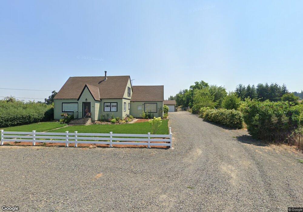
372 Monitor Rd Silverton, OR 97381
Estimated Value: $750,000 - $832,000
3
Beds
2
Baths
2,376
Sq Ft
$332/Sq Ft
Est. Value
About This Home
This home is located at 372 Monitor Rd, Silverton, OR 97381 and is currently estimated at $789,376, approximately $332 per square foot. 372 Monitor Rd is a home located in Marion County with nearby schools including Robert Frost Elementary School, Silverton Middle School, and Silverton High School.
Ownership History
Date
Name
Owned For
Owner Type
Purchase Details
Closed on
Jul 18, 2016
Sold by
Berkey Aaron M and Berkey Lynne M
Bought by
Duda James and Duda Lynde
Current Estimated Value
Home Financials for this Owner
Home Financials are based on the most recent Mortgage that was taken out on this home.
Original Mortgage
$340,533
Interest Rate
3.43%
Mortgage Type
New Conventional
Purchase Details
Closed on
Mar 27, 2007
Sold by
Lethe Bruno C and Lethe Rosina
Bought by
Berkey Aaron M and Berkey Lynne M
Home Financials for this Owner
Home Financials are based on the most recent Mortgage that was taken out on this home.
Original Mortgage
$320,000
Interest Rate
7.37%
Mortgage Type
Unknown
Create a Home Valuation Report for This Property
The Home Valuation Report is an in-depth analysis detailing your home's value as well as a comparison with similar homes in the area
Home Values in the Area
Average Home Value in this Area
Purchase History
| Date | Buyer | Sale Price | Title Company |
|---|---|---|---|
| Duda James | $369,900 | First American | |
| Berkey Aaron M | $400,000 | Ticor Title |
Source: Public Records
Mortgage History
| Date | Status | Borrower | Loan Amount |
|---|---|---|---|
| Previous Owner | Duda James | $340,533 | |
| Previous Owner | Berkey Aaron M | $320,000 |
Source: Public Records
Tax History Compared to Growth
Tax History
| Year | Tax Paid | Tax Assessment Tax Assessment Total Assessment is a certain percentage of the fair market value that is determined by local assessors to be the total taxable value of land and additions on the property. | Land | Improvement |
|---|---|---|---|---|
| 2025 | $2,185 | $177,778 | -- | -- |
| 2024 | $2,185 | $172,730 | -- | -- |
| 2023 | $2,131 | $167,828 | $0 | $0 |
| 2022 | $2,025 | $163,401 | $0 | $0 |
| 2021 | $1,972 | $158,760 | $0 | $0 |
| 2020 | $1,460 | $117,010 | $0 | $0 |
| 2019 | $1,417 | $113,730 | $0 | $0 |
| 2018 | $1,422 | $0 | $0 | $0 |
| 2017 | $1,394 | $0 | $0 | $0 |
| 2016 | $1,362 | $0 | $0 | $0 |
| 2015 | $1,325 | $0 | $0 | $0 |
| 2014 | $1,287 | $0 | $0 | $0 |
Source: Public Records
Map
Nearby Homes
- 990 Sage St
- 0 Rosemary (Lots 615 619 & 623) Way Unit 810404
- 540 Lavender St
- 601 Rosemary Way
- 1703 Webb Lake Dr NE
- 1015 Oak St Unit 109 St
- 1015 Oak St Unit 98 St
- 1015 Oak St Unit 71 St
- 1710 Webb Lake Dr NE
- 319 Monitor Rd
- 1704 Wood Duck St NE
- 1067 Oak St
- 515 Norway St
- 504 Wall St
- 223 Penni Ln
- 195 Iowa St
- 240 Norway St
- 174 Steelhammer Rd
- 155 Breyonna Way
- 1408 Princeton Ave
- 366 Monitor Rd
- 725 Thyme Loop
- 723 Thyme Loop
- 356 Monitor Rd
- 721 Thyme Loop
- 0 Thyme Loop Unit 9089523
- 726 Thyme Loop
- 717 Thyme Loop
- 722 Thyme Loop
- 1651 Eska Way
- 715 Thyme Loop
- 353 Monitor Rd
- 710 Thyme Loop
- 713 Thyme Loop
- 708 Thyme Loop
- 1085 Sage St
- 709 Thyme Loop
- 643 Rosemary (-645) Way
- 1075 Sage St
- 14272 Hobart Rd NE